What's wrong with gas bombs by the fire?DennisDawg wrote:I agree that the folks going around the barricades are going to become a larger problem for us all. There is an ‘old guard’ in wheelin and the folks who follow them, people who are out on the trail, beer cans on the floor boards a full one in hand, gasoline bombs by the fire, shooting up their trash and leaving it there and a trail is wherever they put their rig. You’ll run into them from time to time all over, more so in places, and SBNF is unfortunately one of them.
ARRA road closures in SBNF area
-
Chazz Layne

- Posts: 703
- Joined: Tue Aug 26, 2008 7:39 pm
- Call Sign: KF7FEN
- Location: Prescott, Arizona
- Contact:
Re: ARRA road closures in SBNF area
Chazz Layne—dotcom
-
Chazz Layne
- Posts: 703
- Joined: Tue Aug 26, 2008 7:39 pm
- Call Sign: KF7FEN
- Location: Prescott, Arizona
- Contact:
Re: ARRA road closures in SBNF area
You know, the more I look at this the more I think all involved parties, including the USFS, are missing something here... and I'd venture a guess it is due to a mis-marked trail or a mis-placed trail marker.DennisDawg wrote:I could not find where it stated this was to be closed. The map linked above shows it as still open and in the ARRA map, https://www.fbo.gov/utils/view?id=e7d13 ... 6a7ed40f71 , it is shown as a valid trail. In the Treatment listing https://www.fbo.gov/index?tab=documents ... 8aac3f10d9 there is work on 2N93 to close some side trails and such boulders and more but I did not see where it itself was being closed.Chazz Layne wrote:Yet we are losing the scenic 2N93D, which caused no detectable damage to the surrounding environment, had no bypasses, and did not appear to be eroding in any way whatsoever. Some closures I get, but some leave me baffled (as is the nature of any federal decision I suppose).
I might have missed something (as I often do).
Chazz Layne—dotcom
-
DennisDawg

- Posts: 235
- Joined: Wed Mar 31, 2010 5:36 pm
- Call Sign: K6DOB
- Location: Placentia, CA
Re: ARRA road closures in SBNF area
If you mean gasoline bombs, like “Sobi” or Mickey” bombs, they often qualify under laws and rules pertaining to fireworks (normally illegal) and spray glass about in their non-professional pyrotechnic display that can pose a danger to all, though they are kind of interesting to watch in a what will the hillbilly do next kind of way.Chazz Layne wrote:What's wrong with gas bombs by the fire?
But if you mean, ummmm, human gas, well, ummm, though talk around the campfire can be a lot of fun and laughs, keeping one’s most odoriferous comments to themselves is just good camping etiquette! My mommy taught me that. She tried to teach Daddy also but he didn’t listen.
So, 2N93D is all OK? Isn’t that the trail you mentioned on radio (after you all got off Gold Mtn.), then my buddy and I did in the evening a few Saturdays back, 38 to 38 again, up and over? That is 2N93 and then 2N93D, or am I mistaken?Chazz Layne wrote:You know, the more I look at this the more I think all involved parties, including the USFS, are missing something here... and I'd venture a guess it is due to a mis-marked trail or a mis-placed trail marker.
I will say that the USFS’s work to close ‘side trails’ in and very near Holcomb Valley only blocked off areas for dispersed camping, and will then concentrate all of that into a few small areas, making for a less than pleasant experience. I already experienced that that same weekend.
Local Repeaters On Which You Might Find Me (K6DOB):
- Big Bear K6BB 147.330+ PL: 131.8 - Keller Peak KE6TZG: 146.385+ PL: 146.2 - Sierra Peak KD6DDM 146.610- PL: 103.5
-
Chazz Layne
- Posts: 703
- Joined: Tue Aug 26, 2008 7:39 pm
- Call Sign: KF7FEN
- Location: Prescott, Arizona
- Contact:
Re: ARRA road closures in SBNF area
Yep, it starts just a few yards before Wildhorse Meadows on 2N93 (opposite Yellow Post 54, my favorite camp in SBNF)... at least, it is marked 2N93D. Seeing "2N93D" also referred to as "Lightning Gulch" has me wondering though, as the trail is never inside anything that could be interpreted as a gulch, but spends it's entire ascent/descent on a ridge. Its also not marked on the map as an area being altered.DennisDawg wrote:So, 2N93D is all OK? Isn’t that the trail you mentioned on radio (after you all got off Gold Mtn.), then my buddy and I did in the evening a few Saturdays back, 38 to 38 again, up and over? That is 2N93 and then 2N93D, or am I mistaken?Chazz Layne wrote:You know, the more I look at this the more I think all involved parties, including the USFS, are missing something here... and I'd venture a guess it is due to a mis-marked trail or a mis-placed trail marker.
Chazz Layne—dotcom
-
sdnative
Re: ARRA road closures in SBNF area
I would like to run this sometime. Looks fun. From another web posting, it looks like it climbs to 9800 feet, which is a couple hundred feet higher than the one we did for the prerun.

Re: ARRA road closures in SBNF area
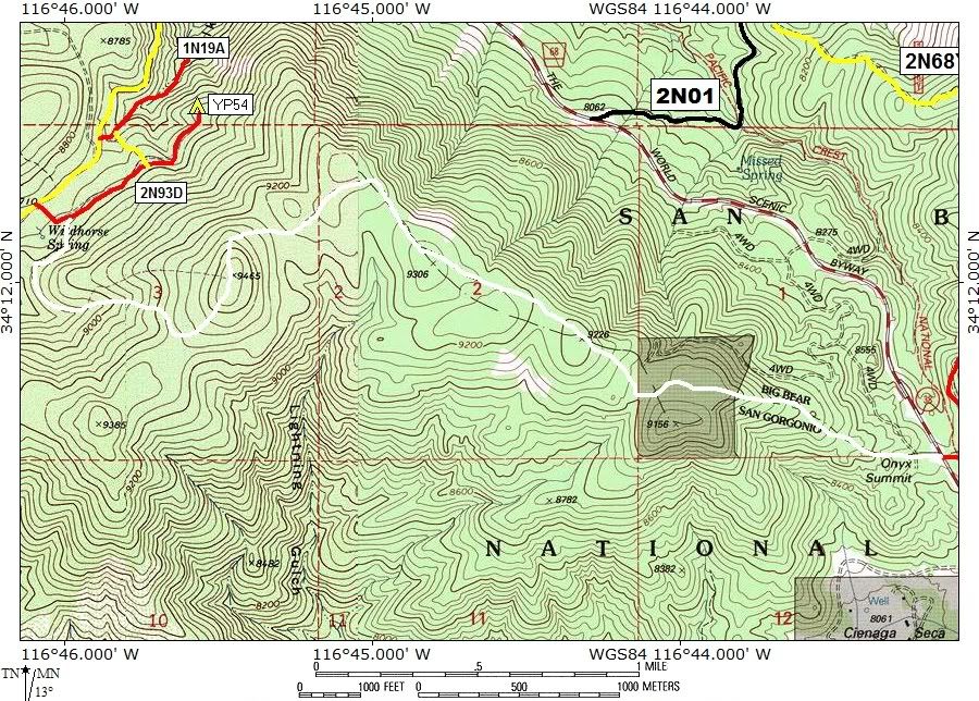
2N93D is the spur road that leads from 2N93 to YP54. The trail that goes from the intersection of 2N93D/2N93 up and over the peak and ends up at Onyx Summit on Hwy 38 is an unauthorized trail. You will not find it on any map published by the SBNF and it has never had a designated route sign on the Hwy 38 side. The 2N93D sign marking the spur road that leads to YP54 may cause confusion that it is a legal trail. On the contractor maps linked earlier in this post it is a brown trail and the legend states that it is an unauthorized route. As I stated in my earlier post I don not know what the contractors plans or the USFS plans are for this unauthorized route.
Doug N1DUG
2004 WJ
1996 ZJ locked on 33's, Claytons LAs
1999 Ford F250 V10 4x4 19.5s, 1988 Lance ES3000
Life Member CA4WD, CORVA, BRC
over 2000 hours volunteered with the SBNFA
CASSP
TreadLightly! Trainer
ForestAid Reforestation Supervisor
2004 WJ
1996 ZJ locked on 33's, Claytons LAs
1999 Ford F250 V10 4x4 19.5s, 1988 Lance ES3000
Life Member CA4WD, CORVA, BRC
over 2000 hours volunteered with the SBNFA
CASSP
TreadLightly! Trainer
ForestAid Reforestation Supervisor
-
Chazz Layne
- Posts: 703
- Joined: Tue Aug 26, 2008 7:39 pm
- Call Sign: KF7FEN
- Location: Prescott, Arizona
- Contact:
Re: ARRA road closures in SBNF area
Ah, that clears it up. Yes, that is the one there on the map. USFS should seriously consider making this a "legit" trail. It isn't terribly difficult (I've done it in a stock vehicle with no damage to trail or truck), and it would be very easy to keep the area in good shape thanks to the terrain/soil.FishPOET wrote:
2N93D is the spur road that leads from 2N93 to YP54. The trail that goes from the intersection of 2N93D/2N93 up and over the peak and ends up at Onyx Summit on Hwy 38 is an unauthorized trail. You will not find it on any map published by the SBNF and it has never had a designated route sign on the Hwy 38 side. The 2N93D sign marking the spur road that leads to YP54 may cause confusion that it is a legal trail. On the contractor maps linked earlier in this post it is a brown trail and the legend states that it is an unauthorized route. As I stated in my earlier post I don not know what the contractors plans or the USFS plans are for this unauthorized route.
They also might want to co-ordinate better with BLM and USGS... it's on those maps.
Chazz Layne—dotcom
-
DennisDawg
- Posts: 235
- Joined: Wed Mar 31, 2010 5:36 pm
- Call Sign: K6DOB
- Location: Placentia, CA
Re: ARRA road closures in SBNF area
Yeah, it is really easy but very pretty up there, lush in places and a few people we saw were doing dispersed camping in the area. Bears might be more of an issue there, the south side tends to have more of them, though I saw two a couple weeks ago at night run in front of my truck near Wilber’s Grave in Holcomb Valley where I have never run into one before. Anyway, bear barrels might be a good thing. But the area is very pretty and near the top seems to be a local favorite in the evening but after that going south, very few people.
Local Repeaters On Which You Might Find Me (K6DOB):
- Big Bear K6BB 147.330+ PL: 131.8 - Keller Peak KE6TZG: 146.385+ PL: 146.2 - Sierra Peak KD6DDM 146.610- PL: 103.5

Re: ARRA road closures in SBNF area
Any offroad closure pisses me off real bad. What is the reason behind it? "recovery" doesn't cut it in my book. $400K of our tax money is paying for this?? no wonder our economy is in the toilet. Its not like people routinely smash thru bushes at 50 mph in this area. I respect the environment. I always leave my campsites cleaner than when i arrived. I always try my best to always stay on the trail, but if some idiots put some rocks in the way, i'll do my best to get them out of the way.
Who is online
Users browsing this forum: No registered users and 3 guests