Page 3 of 3
Re: 2009-09-05: BorregoFest Scouting Trip Report
Posted: Wed Sep 09, 2009 8:00 pm
by BorregoWrangler
sdnative wrote:
ssc wrote:If there is more than one person in the rig, you always have someone to blame.

We know it wasn't a flaw in your driving skills, so it must have been Navigator failure.
It was all John's fault
Hey, what this?! Well ok. I am use to riding in a Jeep so I just didn't take into consideration the Toyota's frailness and inability to traverse the terrain!

Re: 2009-09-05: BorregoFest Scouting Trip Report
Posted: Thu Sep 10, 2009 2:15 pm
by BruisedFJ
BorregoWrangler wrote:sdnative wrote:
ssc wrote:If there is more than one person in the rig, you always have someone to blame.
We know it wasn't a flaw in your driving skills, so it must have been Navigator failure.
It was all John's fault
Hey, what this?! Well ok. I am use to riding in a Jeep so I just didn't take into consideration the Toyota's frailness and inability to traverse the terrain!
John, you really know how to hurt a guy.

See the logo thread for some payback.
Re: 2009-09-05: BorregoFest Scouting Trip Report
Posted: Thu Sep 10, 2009 5:33 pm
by BorregoWrangler
bruisedFJ wrote:John, you really know how to hurt a guy.
See the logo thread for some payback.

All in good fun!
Re: 2009-09-05: BorregoFest Scouting Trip Report
Posted: Thu Sep 10, 2009 11:30 pm
by taugust
I was watching your storm as it happened from Cuyamaca. I watched it develop on radar and outside. It was an amazing storm from my perspective as well. It started south of Ocotillo Wells and remained almost stationary, but grew to immense size. The cloud top rose up and spread out in the classic anvil shape, but spread until it was overhead in Cuyamaca, 29 miles away from the center at about 5:34 pm.
Attached is a photo taken from my house, looking southeast toward Mt. Laguna. You can see mammatus cloud shapes (the puffy pouches hangin from the underside of the cloud). This indicates extreme instability and downward motion from the cloud. You can also see the gust front. This is the diffuse cloud at the ground level at the horizon. This is from the downrush within the thunderstorm hitting the ground and spreading out. This approached and finally arrived at our house about 15 minutes later, blowing about 35 mph. It was very cool and humid, but no rain fell. What was interesting is that gust front came from that roughly 30 mile distance and came up the eastern slopes of the mountains from an elevation of 170 ft. at OW to 4880 ft. at our house. I saw in the NWS severe thunderstorm warnings that I was getting that the outflow boundary on the eastern side was causing 50 mph winds and dust storms.
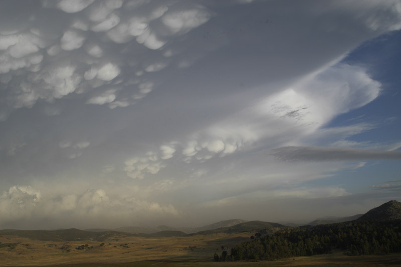
- DSC_5575Low.jpg (60.36 KiB) Viewed 2208 times
Re: 2009-09-05: BorregoFest Scouting Trip Report
Posted: Wed Sep 16, 2009 12:21 am
by taugust
DaveK wrote:Eric:
Those pictures of the clouds are excellent. I've never seen clouds that look like they are dripping like that.
I didn't see the cloud photos on the first go around since I am on dialup and they didn't all download. That wispy look hanging down from a dark cloud is also a sign of extreme instability, meaning vertical movement in the cloud. I saw those same type of filaments hanging from a cloud that shortly thereafter generated a funnel cloud. If you see that, keep your eyes on the sky!
I sent a link to this post to Miguel at the National Weather Service in San Diego, and he has forwarded it to others. They were impressed and pleased to see the photos and the report.
Re: 2009-09-05: BorregoFest Scouting Trip Report
Posted: Wed Sep 16, 2009 7:48 am
by sdnative
Thanks Tim.
I can provide full res images if they need them.