Donate

Off Road Notebook Computer

Navigation tools including maps, compass, GPS, computers, software, and other forms of navigation.
User avatar
DaveK
Site Admin
Posts: 3849
Joined: Tue Mar 11, 2008 10:33 am
Call Sign: K6DTK
Location: American Southwest

Re: Off Road Notebook Computer

Post by DaveK » Fri Jun 27, 2008 1:29 pm

taugust wrote:Yep, having the ability to share info, (in this case, carefully and sometimes painfully, entered info) is a real benefit. I'm not familiar with the RT software, but I assume it is aftermarket usable with both makes of radio. For Icom's proprietary software, it is only good with a particular model radio. A generic solution is pretty cool.

Tim:

The new 3.0 version of the RT software makes it possible to transfer information to both ICOM and Yaesu radios. The only caveat though is that you must buy the software for each radio, either ICOM or Yaesu. As I have viewed their offerings, they make software for many of the popular models, but not everything. I suppose its possible for those running really old stuff, that this will not work. Otherwise its a great time saver and backup!

Considering how much time I spent entering all the info into my radios, I sure would hate to have to do it again manually!!!
DaveK
K6DTK


Extremism in the defense of liberty is no vice.
Moderation in the pursuit of justice is no virtue.

User avatar
DaveK
Site Admin
Posts: 3849
Joined: Tue Mar 11, 2008 10:33 am
Call Sign: K6DTK
Location: American Southwest

Re: Off Road Notebook Computer

Post by DaveK » Wed Aug 13, 2008 9:55 pm

Just a quick post script:

I had the opportunity recently to transfer the information in one of my Yaesu radios to my ICOM radio using the RT Systems software. It took about 5 minutes (hooking up cables and a couple of key strokes) to transfer almost 100 different repeaters and simplex frequencies including all names, pl's, offsets, etc. Since the ICOM had a greater name capacity, I was even able to give the full names where previously, with the Yaesu, only a few letters were allowed.

As long as the radios are ICOM and Yaesu, the RT Systems software is a tremendous time saver.
DaveK
K6DTK


Extremism in the defense of liberty is no vice.
Moderation in the pursuit of justice is no virtue.

User avatar
cruiserlarry
OAUSA Board Member
Posts: 2646
Joined: Sun Mar 30, 2008 10:23 pm
Call Sign: W6LPB
Location: Los Angeles, CA
Contact:

Re: Off Road Notebook Computer

Post by cruiserlarry » Wed Aug 13, 2008 11:32 pm

Is there a list of specific radios the software will upload to ? Maybe we could set up a basic list so that everyone will have the same info in the same memory location - would make it easy to change "channels" together when we're out on the trail...
Light travels faster than sound. This is why some people appear really bright, until they start talking

W6LPB / WPOK492

Become a DIRTY PARTS FACEBOOK fan !!!

User avatar
DaveK
Site Admin
Posts: 3849
Joined: Tue Mar 11, 2008 10:33 am
Call Sign: K6DTK
Location: American Southwest

Re: Off Road Notebook Computer

Post by DaveK » Thu Aug 14, 2008 12:02 am

cruiserlarry wrote:Is there a list of specific radios the software will upload to ? Maybe we could set up a basic list so that everyone will have the same info in the same memory location - would make it easy to change "channels" together when we're out on the trail...

Yes, there is a list. This following is from the RT Systems website and are the radios for which they make programmers. Programming data can be transferred from any listed radio to any other listed radio as long as you have purchased the v3 software for that particular radio.


Icom VHF/UHF Handhelds

WCS-T2 Windows Cloning Software for the IC-T2
Version 3.70
WCS-T7 Windows Cloning Software for the IC-T7
Version 3.70
WCS-T8 Windows Cloning Software for the IC-T8
Version 3.70
WCS-T81 Windows Cloning Software for the IC-T81
Version 3.70
WCS-W32 Windows Cloning Software for the IC-W32
Version 3.70
WCS-Q7 Windows Cloning Software for the IC-Q7
Version 3.70
WCS-T90 Windows Cloning Software for the IC-T90
Version 3.70
WCS-91 Windows Cloning Software for the IC-91
Version 3.70


Icom VHF/UHF Mobiles

WCS-2100 Windows Cloning Software for the IC-2100
Version 3.70
WCS-2200 Windows Cloning Software for the IC-2200
Version 3.70
WCS-V8000 Windows Cloning Software for the IC-V8000
Version 3.70
WCS-208 Windows Cloning Software for the IC-208
Version 3.70
WCS-2720 Windows Cloning Software for the IC-2720
Version 3.70
WCS-7000 Windows Cloning Software for the IC-7000
Version 3.70

Icom Receivers
WCS-R2 Windows Cloning Software for the IC-R2
Version 3.70
WCS-R10 Windows Cloning Software for the IC-R10
Version 3.70


Yaesu HF/VHF/UHF Mobile Radios
ADMS-4A Advanced Data Management System Programmer for the FT-817/817D
Version 2
ADMS-4B Advanced Data Management System Programmer for the FT-857/857D
and FT-897/897D
Version 2

Yaesu Handheld Radios
ADMS-FT50 Advanced Data Management System for the FT-50
Version 3.70
ADMS-VX1 Advanced Data Management System for the VX-1
Version 3.70
ADMS-VX5 Advanced Data Management System for the VX-5
Version 3.70
ADMS-1F Advanced Data Management System for the VX-110 and VX-150
Version 3.70
ADMS-1G Advanced Data Management System for the VX-7
Version 3.70
ADMS-1H Advanced Data Management System for the VX-2
Version 3.70
ADMS-1J Advanced Data Management System for the FT-60
Version 3.70
ADMS-VX3 Advanced Data Management System for the VX-3
Version 3.70
ADMS-VX6 Advanced Data Management System for the VX-6
Version 3.70
ADMS-VX170 Advanced Data Management System for the VX-120 and VX-170
Version 3.70
ADMS-VX177 Advanced Data Management System for the VX-127 and VX-177
Version 3.70

Yaesu VHF/UHF Mobile Radios

ADMS-2E Advanced Data Management System
for the FT-90 and FT-2600
Version 2
ADMS-2F Advanced Data Management System for the FT-1500
Version 2
ADMS-2G Advanced Data Managemenr System for the FT-7100
Version 2
ADMS-FT8000 Advanced Data Management System for the FT-8000
Version 3.70
ADMS-FT8100 Advanced Data Management System for the FT-8100
Version 3.70
ADMS-2H Advanced Data Management System for the FT-8900
Version 3.70
ADMS-2I Advanced Data Management System for the FT-8800
Version 3.70
ADMS-2J Advanced Data Management System for the FT-2800
Version 2
ADMS-2K Advanced Data Management System for the FT-7800
Version 3.70
ADMS-1802 Advanced Data Management System for the FT-1802
Version 3.70
ADMS-1807 Advanced Data Management System for the FT-1807
Version 3.70
DaveK
K6DTK


Extremism in the defense of liberty is no vice.
Moderation in the pursuit of justice is no virtue.

User avatar
latinoguy
Posts: 4
Joined: Mon Aug 18, 2008 9:53 am
Location: Coachella Valley

Re: Off Road Notebook Computer

Post by latinoguy » Tue Aug 26, 2008 8:39 am

[quote="DaveK"]OK, it took a while to get going but here it is. Garmin 276C, loaded with Garmin's Topo connected to a Panasonic laptop running Nat. Geo's USGS Topo! With automatic tracking, you can create a track of where you have been as well as where you are and with the detail of the USGS TOPO maps, you have some of the most detailed and accurate maps available. One of the advantages of this system is that you can run both mapping programs (NG and Garmin) at the same time, you can download all waypoints from the 276 to the hard drive, you can create routes with the PC and up load them to the 276 and you can create waypoints on the PC and up load them to the 276. With version 4 of TOPO!, 3d views are available as is shaded relief and a road highlighter. quote]

Thread revival,

Dave, Is there a reason you did not go with or stay with just Garmin Topo 2008, Doesn't it serve the same purpose as Nat Geo's USGS Topo Software? Am I missing a piece of the puzzle? I ask because I am just starting to get into the GPS Nav systems...
I am currently running Garmin Topo 08 with a Garmin Vista GPS and Nsource on my laptop to get live tracking....
After a trial run I am very pleased....
97 FZJ80, "La Mula" DD, ARB, Tire Carrier, Sliders, OME 850J/863 springs, L shocks, 295/75/R16, Slee TC Skid Plate, Rear Storage, CB, LEDs, SS Brake Lines, Rear work lights, GPS, HIRs Highs&Lows "Beauty is in the eye of the beer holder."

User avatar
unwiredadventures
Posts: 392
Joined: Thu Apr 24, 2008 8:50 pm
Call Sign: KG6JVE
Location: Pasa Bernardino
Contact:

Re: Off Road Notebook Computer

Post by unwiredadventures » Tue Aug 26, 2008 9:08 am

AFAIK, National Geographic's TOPO! is the only (low cost) software with raster images of the actual USGS maps with hand written notes and all.

Most of those handwritten notes are missing from most all of the other topographical packages (DeLorme, Garmin etc).

The hand written notes have things like cemeteries, petroglyphs and other locations that are otherwise not included with the other mapping packages.
'97 Land Cruiser FZJ80

Trip Photos | Twitter

User avatar
DaveK
Site Admin
Posts: 3849
Joined: Tue Mar 11, 2008 10:33 am
Call Sign: K6DTK
Location: American Southwest

Re: Off Road Notebook Computer

Post by DaveK » Tue Aug 26, 2008 9:27 am

Hey latinoguy:

Welcome. Your take on the Garmin Topo 2008 is very accurate. The 2008 upgrade from their previous version is a significant improvement. It has many features that I very much appreciate. In some respects, the selection of mapping software is a Ford vs Chevy kind of thing. The truth is that you really can't go wrong with either one. I actually run both and have been very happy.

My personal preference for the USGS maps (now sold through Nat. Geo.) is based on their accuracy. Almost without exception, all of the other mapping systems utilize the USGS maps as a basis for their maps and that includes the Garmin system. From the USGS Web Site: "The USGS took over responsibility for mapping the country in 1879 and has been the primary civilian mapping agency of the United States ever since. The best known USGS maps are the 1:24,000-scale topographic maps, also known as 7.5-minute quadrangles. More than 55,000 7.5-minute maps were made to cover the 48 conterminous States. This is the only uniform map series that covers the entire area of the United States in considerable detail." While Garmin, Magellan, Lowarance and the rest of the mapping software makers are very successful and have made good mapping software, none have the budget that the US government has been able to devote to mapping the USA and none have been at it as long. For me, the USGS topo maps are the most accurate.

You might want to run both and see which one suits your needs best and which one is most user friendly for you. Again, I don't believe that you can go wrong with either one. Please post your results.
DaveK
K6DTK


Extremism in the defense of liberty is no vice.
Moderation in the pursuit of justice is no virtue.

User avatar
latinoguy
Posts: 4
Joined: Mon Aug 18, 2008 9:53 am
Location: Coachella Valley

Re: Off Road Notebook Computer

Post by latinoguy » Tue Aug 26, 2008 4:00 pm

Thanks for the explanation Frank and Dave. I finally subscribed here after lurking around for a while...(migrated over from adventure4x4 forum...)

The advice to play with both topo mapping software is very alluring but I will take baby steps for now since I am just getting into it this past month...I am curious on Ozie Explorer from what I've read as well...much to learn much to learn...
97 FZJ80, "La Mula" DD, ARB, Tire Carrier, Sliders, OME 850J/863 springs, L shocks, 295/75/R16, Slee TC Skid Plate, Rear Storage, CB, LEDs, SS Brake Lines, Rear work lights, GPS, HIRs Highs&Lows "Beauty is in the eye of the beer holder."

User avatar
unwiredadventures
Posts: 392
Joined: Thu Apr 24, 2008 8:50 pm
Call Sign: KG6JVE
Location: Pasa Bernardino
Contact:

Re: Off Road Notebook Computer

Post by unwiredadventures » Tue Aug 26, 2008 5:00 pm

Here's a good example of the handwritten notes in a TOPO! USGS map image. See the notes for "Petroglyph" (upper right corner), "Wash" and "Old Govt Road to Old Fort Mojave":

Image


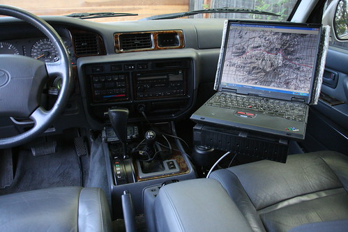
TOPO! running live in my truck, look closely you can see the red track line:
Image
'97 Land Cruiser FZJ80

Trip Photos | Twitter

User avatar
cruiserlarry
OAUSA Board Member
Posts: 2646
Joined: Sun Mar 30, 2008 10:23 pm
Call Sign: W6LPB
Location: Los Angeles, CA
Contact:

Re: Off Road Notebook Computer

Post by cruiserlarry » Tue Aug 26, 2008 7:25 pm

unwiredadventures wrote:Here's a good example of the handwritten notes in a TOPO! USGS map image. See the notes for "Petroglyph" (upper right corner), "Wash" and "Old Govt Road to Old Fort Mojave":
That's really great - a little insight on the map to help out with the surroundings.
Light travels faster than sound. This is why some people appear really bright, until they start talking

W6LPB / WPOK492

Become a DIRTY PARTS FACEBOOK fan !!!

Post Reply

Return to “NAVIGATION”

Who is online

Users browsing this forum: No registered users and 1 guest