Page 7 of 14
Re: Off Road Notebook Computer
Posted: Fri Oct 17, 2008 10:48 am
by SteveS
Hardluck wrote:... Delorme Earthmate ....and Oziexplorer...Delorme's..serial emulation driver.....
Hi Hardluck, I have a Q
I also use Ozi and the Delorme antenna, and I’ve been running that same driver the last few years. Seems to work well for me and I like the handy elevation and speed display.
I do get a spike in my track data from time to time. Do you get any spikes or corrupt track data? It so easy to fix these spikes I’ve never see it as a problem, just curious if other get the same.
I’ve been running this program since Nov. 05, I just checked it while learning I have Ver 1.0
Re: Off Road Notebook Computer
Posted: Fri Oct 17, 2008 3:45 pm
by Hardluck
SteveS wrote:Hardluck wrote:... Delorme Earthmate ....and Oziexplorer...Delorme's..serial emulation driver.....
Hi Hardluck, I have a Q
I also use Ozi and the Delorme antenna, and I’ve been running that same driver the last few years. Seems to work well for me and I like the handy elevation and speed display.
I do get a spike in my track data from time to time. Do you get any spikes or corrupt track data? It so easy to fix these spikes I’ve never see it as a problem, just curious if other get the same.
I’ve been running this program since Nov. 05, I just checked it while learning I have Ver 1.0
I've never had that problem with corrupt track data. I believe I'm using version 1.1 of the serial emulator.
Re: Off Road Notebook Computer
Posted: Fri Oct 17, 2008 3:48 pm
by Hardluck
cruiserlarry wrote:Hardluck wrote:cruiserlarry wrote:I bought a SiRF III USB GPS receiver, but it is not recognized by the National Geographic Topo program as far as I've been able to check so far. I'm going to call them to see if there is something I can do to make it work, or if there is anothe USB GPS receiver that is compatible (I mistakenly assumed any USB GPS recever could work with the program). So I've got the maps all loaded up, but I can't use it with GPS yet. I'm hoping I can either tap into the NMEA 183 output from the Lowrance GlobalMap 540C (which uses a network system with special cables) or get this receiver to work. Anyone who has any experience with this issue, let me know...
(It's a Toughbook CF-29)
I had a similar problem with my Delorme Earthmate Bt-20 (a bluetooth receiver) and Oziexplorer. I had to go to Delorme's website and download a serial emulation driver so that it could be recognized on NMEA 0183 mapping software.
Thanks. I'll contact NG, and see if they offer a similar download...(or maybe the DeLorme driver will do the trick).
In case you want to try it out here's a link to the delorme emulator
http://www.delorme.com/support/supportt ... spx?id=319
Re: Off Road Notebook Computer
Posted: Sat Oct 18, 2008 8:14 am
by SteveS
Hardluck wrote:SteveS wrote:[... I have Ver 1.0
I've never had that problem with corrupt track data. I believe I'm using version 1.1 of the serial emulator.
THANKS thats good to know. I sure like Ozi and the overlays I can have with me on the trail.

I did learn a week ago on my last trip that reporting a crime scene located in the back-country to law enforcement in this day and age of GPS accuracy is no easier than 8-10 years ago before GPS.

Thanks agin Hardluck
Re: Off Road Notebook Computer
Posted: Sun Oct 19, 2008 9:43 am
by Hardluck
SteveS wrote:THANKS thats good to know. I sure like Ozi and the overlays I can have with me on the trail.
I did learn a week ago on my last trip that reporting a crime scene located in the back-country to law enforcement in this day and age of GPS accuracy is no easier than 8-10 years ago before GPS.
Thanks agin Hardluck
No problem. So far, I'm loving Ozi even with its steep learning curve. The flexibility of Ozi is amazing.
I'm thinking that crime scene reporting story deserves its own thread...

Re: Off Road Notebook Computer
Posted: Wed Oct 22, 2008 9:56 am
by SteveS
Hardluck wrote: .... The flexibility of Ozi is amazing....
Yes I agree.
A few years back when I was off exploring the San Refuel Swell. I picked up a brochure that the State of Utah put out. It had a neat map with numbered POI on the back side. The map was scaleable so we loaded it to Ozi, and our vehicle showed on the map as we traveled. We then used the paper brochure to read about the numbered POI as we got to them. It was like being spoon-feed at Disneyland.

Since then I've found alot more useful tasks for Ozi.
Re: Off Road Notebook Computer
Posted: Wed Nov 12, 2008 10:18 pm
by DaveK
As is evident from the posts here, there are several mapping programs that serve the outdoor traveler. Since it is only practical to use one GPS to connect to your computer whilst offroad, generally it is possible to only run one mapping program at a time. Problem solved. Fransen's GPSgate software (
http://franson.com/gpsgate/ )uses the input from one GPS and splits it for use for several mapping programs, all running at the same time. The following is from their website:
The main purpose of GpsGate is to share one GPS between several GPS applications running at the same time. In its simplest form GpsGate is very easy to install and setup for a novice user.
For the more advanced user there are many other uses as well, like GPS simulator, Logger, protocol translation, sharing over ActiveSync and network sharing to just mention a few, the options for configuration and usage are endless.
The program allows me to run two mapping programs, on a split screen, as follows:
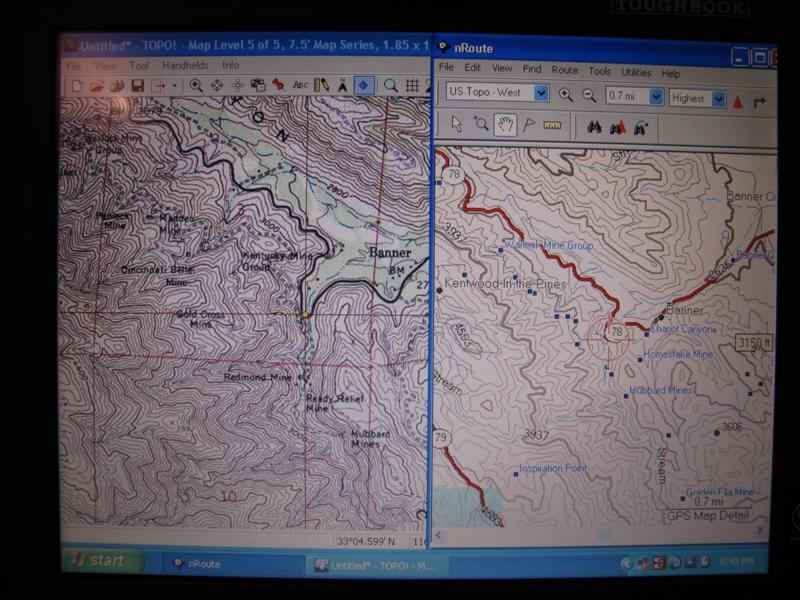
- IMG_0587 (Medium).JPG (94.03 KiB) Viewed 6893 times
One caveat: GPS gate is an amazing tool. Finding the right combination of settings may not be for the faint of heart or those with little patience. If you plan on running NG Topo!, I have discovered the right combination. Not an easy task. Their customer support is forum based and their tech guy is quite prompt. Patience will pay off once you get it up and running.
Re: Off Road Notebook Computer
Posted: Wed Nov 12, 2008 11:05 pm
by cruiserlarry
Thanks for the info on GPSgate..
I'm glad I have a toughbook and NG topo software, so I can use the settings you've worked so hard to figure out...

Re: Off Road Notebook Computer
Posted: Fri Nov 14, 2008 12:17 am
by DaveK
cruiserlarry wrote:Thanks for the info on GPSgate..
I'm glad I have a toughbook and NG topo software, so I can use the settings you've worked so hard to figure out...
It'll be my pleasure to set you up. Bring it next time we get together.
Re: Off Road Notebook Computer
Posted: Fri Nov 28, 2008 10:49 pm
by DaveK
With digital cameras and long trips, its not difficult to come to the end of a trip with a huge quantity of photos and some difficulty in remembering just where each picture was taken (assuming, of course, that your camera does not have a built in GPS). If you run a GPS in your rig while you travel, it is now possible to combine the information produced by the GPS (for your trip) with the image data from your camera and determine where each picture was taken (or relatively close). The software, from Breeze Systems,
http://breezesys.com/BreezeBrowser/index.htm , will do what they call "geo-tag" your images with the coordinates from your GPS by matching the time of the photo with the same time from the GPS and place this info on the image with the lat., long, and altitude.
It also has the ability to display each image or a symbol of the image on online map services like Google Earth. This feature is only available for online services and cannot, at this time, be used with computer mapping programs like NG Topo!.
Interesting!