Page 1 of 1
2010-01-15 Whale Peak Summit - North Approach
Posted: Sat Jan 16, 2010 1:25 pm
by OLLIE
What can I say....? Ouch, wow, damn, amazing, beat up, tired, and well worth it.
 Planned Numbers
Distance: 4 Miles, Out and Back
Hiking Time: 3-4 Hours (roundtrip)
Actual Numbers
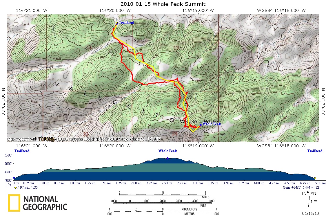
Distance: 5.3 Miles, Out and Back
Hiking Time: 6 Hours (roundtrip)
LINK TO PHOTOS:
http://www.flickr.com/photos/fj-ollie/s ... 106510505/
Here is the view I got from the top... I will post some more pics after I get them processed. This panorama was done by a friend who went with me. He stitched several pictures together to create it.


- DSC_3025 Panorama-2.jpg (568.18 KiB) Viewed 2134 times

- Red is actual route. Yellow was preplotted route.
- 2010-01-15 Whale Peak Summit.JPG (460.61 KiB) Viewed 2123 times
Re: 2010-01-15 Whale Peak Summit - North Approach
Posted: Sat Jan 16, 2010 2:47 pm
by Fetus
Awesome shot, I need to figure out how to do those panoramas.
Re: 2010-01-15 Whale Peak Summit - North Approach
Posted: Sat Jan 16, 2010 5:38 pm
by Chazz Layne
Fetus wrote:Awesome shot, I need to figure out how to do those panoramas.
Panorama Factory takes 90% of the effort out of it.

Re: 2010-01-15 Whale Peak Summit - North Approach
Posted: Sat Jan 16, 2010 6:35 pm
by BorregoWrangler
Cool picture.
I was looking at that hike in one of my books. Looks like you guys had a nice day out there.
Re: 2010-01-15 Whale Peak Summit - North Approach
Posted: Sat Jan 16, 2010 10:36 pm
by photojeeper
If you would have done this next Friday I would have joined you. That is one on my list to do, Ghost Mountain is a good one it is only a mile one way. I am going to do it again this Spring, going to hike along the ridge then come back down. Post up the GPS file too.
JJ
Re: 2010-01-15 Whale Peak Summit - North Approach
Posted: Sun Jan 17, 2010 8:53 am
by OLLIE
photojeeper wrote:If you would have done this next Friday I would have joined you. That is one on my list to do, Ghost Mountain is a good one it is only a mile one way. I am going to do it again this Spring, going to hike along the ridge then come back down. Post up the GPS file too.
JJ
The GPX file has been added to the first post. This is a rather brutal approach. I think I would recommend a Blaire Valley approach if you haven't been conditioning. It is longer but won't beat you up as bad.

