Southern California Backpack & Hiking Trails
Posted: Fri Aug 27, 2010 5:44 am
Southern California Backpack & Hiking Trails
In this thread I would like to provide a source of information on hiking and backpacking routes that I’ve been on or that I plan on doing. Along with a brief description of each route I’ll also add maps, pictures, or a link to any trip reports I have or can find. For me, at least, going over this information helps motivate me to get out now and then to stretch my legs. I'll also update info and add trips here as I go.
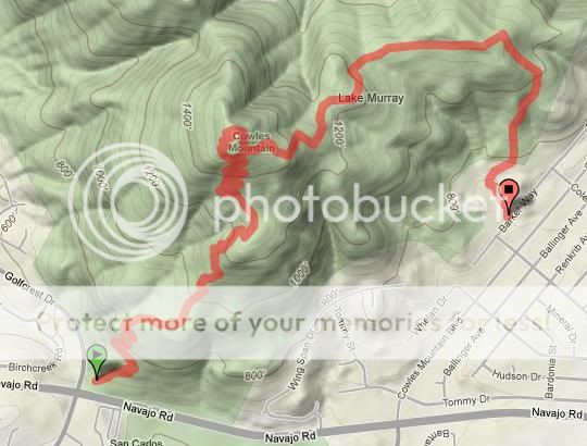
Cowles Mountain
This is the highest point within San Diego’s city limits and makes for a very easy-to-reach place to get out and stretch your legs. Located within the Mission Trails Regional Park which borders Santee, El Cajon, San Carlos, and Tierrasanta, there are several routes to the summit. The most poplar is the south approach from the trailhead off Golfcrest and Navajo Drive. This route consists of many switchbacks cut into mostly decomposed granite.
From the east, one can travel up a graded service road that begins near the west end of Boulder Lake Avenue at Barker Way. Good traction is needed on a few very steep sections of this route. You will, however, be rewarded with less of a crowd than on the south approach. The routes described thus far are a 3 mile round trip taking 2 hours.
The most difficult way to the summit is also the most beautiful. From Big Rock Park in Santee, you approach from the northeast sharply uphill through dense chaparral to reach a junction with the service road. During the spring, keep an eye out for rattlesnakes. Allow for about 3 hours for this 4.8 mile trip.
Link: http://www.oausa.net/forums/viewtopic.php?f=32&t=1996
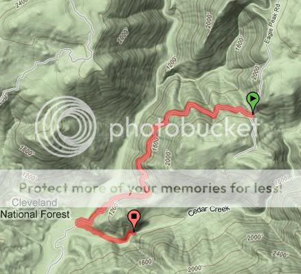
Cedar Creek Falls
On warm spring and early summer weekends you can find a number of folks making the trek down to one of San Diego’s hidden jewels, Cedar Creek Falls. Located in a tributary of the San Diego River, one can reach this area from the trailhead at the end of Eagle Peak Road just south of Pine Hills and Julian or near the end of Ramona Oaks Road in Ramona. The most popular route, from Eagle Peak Road, follows the remains of an old dirt road offering views along the San Diego River and Mildred Falls, the county’s highest at more than 100 feet.
At 1.4 miles there’s a spur road that takes you to the top of the falls. Be cautious around the slippery rocks. Continuing down and around to the base of the falls reveals a punchbowl about 50 feet wide and 20 feet deep above the 90 foot cascade. This is a popular swimming hole. Make sure to carry plenty of drinking water if you attempt this journey during the hotter summer days. Many people underestimate this hike in the summer and are often airlifted out by the forest service. Note the following article.
From North County Times July 17, 2010
Ramona: Hikers, dog rescued in Cleveland National Forest
"Four hikers suffering from heat exhaustion were rescued Saturday in Cleveland National Forest, officials said.
California Department of Forestry and Fire Protection workers responded at about 4 p.m. to reports that hikers had suffered heat exhaustion on the Cedar Creek trail, CalFire Capt. Daryll Pina said.
He said rescuers drove to the hikers and rescued them along with one of the two dogs they had taken on the hike.
The other dog died because of the heat, he said.
Ramona Community Emergency Response Team volunteers were at the trail head to provide shelter and water to hikers who braved the 115-degree heat reported in areas of the canyon, Pina said. He said rescuers have responded to more than a dozen heat-related injuries on the trail during the last three weekends."
Allow about 3 hours for this 5 mile round trip.
Link: http://www.expeditionportal.com/forum/s ... hp?t=12079
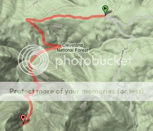
Three Sisters Waterfalls
Located not too far away from Cedar Creek Falls is this triple set of waterfalls in Boulder Creek. The trailhead is on Boulder Creek Road at a hairpin turn and junction with Cedar Creek Road. Follow an old ranch road west for 0.7 miles to a saddle and turn left downhill towards Sheep Camp Creek. Once over the creek and around the bend, you’ll emerge from the vegetation and be able to see and hear the falls. Soon comes a difficult, near vertical 500 foot drop on a primitive trail. At the bottom, follow the creek to the base of the falls, keeping an eye out for poison oak along the way. The middle 50 foot waterfall has an 80 foot long pool that’s about 10 feet deep. You can make your way to the uppermost fall along a narrow and slippery route up the right side. Allow about 3 hours for this 4 mile round trip, although much more time can be spent exploring and relaxing around the area.
Trip Report: http://www.oausa.net/forums/viewtopic.php?f=32&t=2024
Kitchen Creek Falls
On the southern slopes of the Laguna Mountains, the Pacific Crest Trail passes just 200 yards above a hidden series of waterfalls in Kitchen Creek. Here, water from about 20 square miles of drainage flows through a narrow section in the bedrock, and tumbles about 150 vertical feet over water-polished slabs.
After a major storm passes through, the sound of falling water gives away the location of the falls; at other times, finding them may be a bit difficult. A short stretch of moderate scrambling is required to reach them. Park just outside Boulder Oaks Campground off Old Highway 80 (just down from the Buckman Springs exit off Interstate 8) and cross the road to a pathway marked by a PCT post. Allow 2 ½ hours for this 4.5 mile hike.
Trip Report: http://www.oausa.net/forums/viewtopic.php?f=32&t=1006

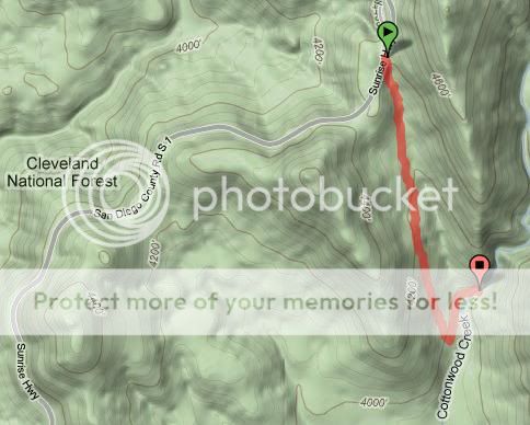
Cottonwood Creek Falls
Also within the Laguna Mountains, though less impressive than Kitchen Creek Falls are the easily accessible Cottonwood Creek Falls. Located just a little ways off Sunrise Highway, these waterfalls offer swimming holes. Park at one of the two large turnouts along Sunrise Highway between mile 15.3 and 15.4 and pick up a narrow trail from the top of the draw. At the bottom this route intersects with another dirt road. Make a sharp left and travel north a short ways to Cottonwood Creek. At the top, the creek drops 10 feet into a 4 foot pool. This 1.8 mile round trip will take just one hour.
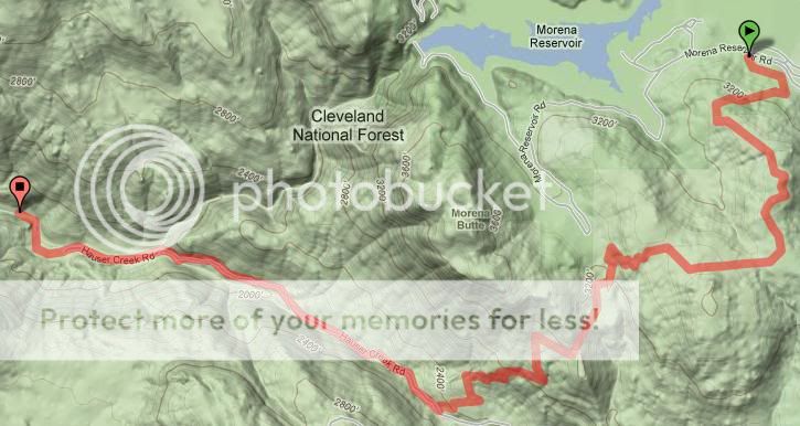
Hauser Canyon
This hike follows a now closed vehicle trail to an old forest service campground. The trip starts out along the Pacific Crest Trail just east of Lake Morena. After loosing 900 feet of elevation the trail crosses the old Hauser Creek Road. From here turn right and travel west along the oak and sycamore-lined creek. The old campground is reached at 6.3 miles next to a concrete dam that may still contain fish. A little ways further down is the Marine Memorial to the nine Marine Corps fire fighters who died there in 1943. Since this is a known smuggling route it may be wise to check with the Descanso Ranger District about any safety concerns. Allow at least 8 hours for this 14 mile round hike.
Link: http://www.signonsandiego.com/news/2010 ... er-canyon/
Coming soon-
Carrizo Gorge
Montero Palms to Goat Canyon
California Riding & Hiking Trail
Middle Willows (Coyote Canyon)
Pacific Crest Trail (Parts 1 & 2)
In this thread I would like to provide a source of information on hiking and backpacking routes that I’ve been on or that I plan on doing. Along with a brief description of each route I’ll also add maps, pictures, or a link to any trip reports I have or can find. For me, at least, going over this information helps motivate me to get out now and then to stretch my legs. I'll also update info and add trips here as I go.
Cowles Mountain
This is the highest point within San Diego’s city limits and makes for a very easy-to-reach place to get out and stretch your legs. Located within the Mission Trails Regional Park which borders Santee, El Cajon, San Carlos, and Tierrasanta, there are several routes to the summit. The most poplar is the south approach from the trailhead off Golfcrest and Navajo Drive. This route consists of many switchbacks cut into mostly decomposed granite.
From the east, one can travel up a graded service road that begins near the west end of Boulder Lake Avenue at Barker Way. Good traction is needed on a few very steep sections of this route. You will, however, be rewarded with less of a crowd than on the south approach. The routes described thus far are a 3 mile round trip taking 2 hours.
The most difficult way to the summit is also the most beautiful. From Big Rock Park in Santee, you approach from the northeast sharply uphill through dense chaparral to reach a junction with the service road. During the spring, keep an eye out for rattlesnakes. Allow for about 3 hours for this 4.8 mile trip.
Link: http://www.oausa.net/forums/viewtopic.php?f=32&t=1996
Cedar Creek Falls
On warm spring and early summer weekends you can find a number of folks making the trek down to one of San Diego’s hidden jewels, Cedar Creek Falls. Located in a tributary of the San Diego River, one can reach this area from the trailhead at the end of Eagle Peak Road just south of Pine Hills and Julian or near the end of Ramona Oaks Road in Ramona. The most popular route, from Eagle Peak Road, follows the remains of an old dirt road offering views along the San Diego River and Mildred Falls, the county’s highest at more than 100 feet.
At 1.4 miles there’s a spur road that takes you to the top of the falls. Be cautious around the slippery rocks. Continuing down and around to the base of the falls reveals a punchbowl about 50 feet wide and 20 feet deep above the 90 foot cascade. This is a popular swimming hole. Make sure to carry plenty of drinking water if you attempt this journey during the hotter summer days. Many people underestimate this hike in the summer and are often airlifted out by the forest service. Note the following article.
From North County Times July 17, 2010
Ramona: Hikers, dog rescued in Cleveland National Forest
"Four hikers suffering from heat exhaustion were rescued Saturday in Cleveland National Forest, officials said.
California Department of Forestry and Fire Protection workers responded at about 4 p.m. to reports that hikers had suffered heat exhaustion on the Cedar Creek trail, CalFire Capt. Daryll Pina said.
He said rescuers drove to the hikers and rescued them along with one of the two dogs they had taken on the hike.
The other dog died because of the heat, he said.
Ramona Community Emergency Response Team volunteers were at the trail head to provide shelter and water to hikers who braved the 115-degree heat reported in areas of the canyon, Pina said. He said rescuers have responded to more than a dozen heat-related injuries on the trail during the last three weekends."
Allow about 3 hours for this 5 mile round trip.
Link: http://www.expeditionportal.com/forum/s ... hp?t=12079
Three Sisters Waterfalls
Located not too far away from Cedar Creek Falls is this triple set of waterfalls in Boulder Creek. The trailhead is on Boulder Creek Road at a hairpin turn and junction with Cedar Creek Road. Follow an old ranch road west for 0.7 miles to a saddle and turn left downhill towards Sheep Camp Creek. Once over the creek and around the bend, you’ll emerge from the vegetation and be able to see and hear the falls. Soon comes a difficult, near vertical 500 foot drop on a primitive trail. At the bottom, follow the creek to the base of the falls, keeping an eye out for poison oak along the way. The middle 50 foot waterfall has an 80 foot long pool that’s about 10 feet deep. You can make your way to the uppermost fall along a narrow and slippery route up the right side. Allow about 3 hours for this 4 mile round trip, although much more time can be spent exploring and relaxing around the area.
Trip Report: http://www.oausa.net/forums/viewtopic.php?f=32&t=2024
Kitchen Creek Falls
On the southern slopes of the Laguna Mountains, the Pacific Crest Trail passes just 200 yards above a hidden series of waterfalls in Kitchen Creek. Here, water from about 20 square miles of drainage flows through a narrow section in the bedrock, and tumbles about 150 vertical feet over water-polished slabs.
After a major storm passes through, the sound of falling water gives away the location of the falls; at other times, finding them may be a bit difficult. A short stretch of moderate scrambling is required to reach them. Park just outside Boulder Oaks Campground off Old Highway 80 (just down from the Buckman Springs exit off Interstate 8) and cross the road to a pathway marked by a PCT post. Allow 2 ½ hours for this 4.5 mile hike.
Trip Report: http://www.oausa.net/forums/viewtopic.php?f=32&t=1006
Cottonwood Creek Falls
Also within the Laguna Mountains, though less impressive than Kitchen Creek Falls are the easily accessible Cottonwood Creek Falls. Located just a little ways off Sunrise Highway, these waterfalls offer swimming holes. Park at one of the two large turnouts along Sunrise Highway between mile 15.3 and 15.4 and pick up a narrow trail from the top of the draw. At the bottom this route intersects with another dirt road. Make a sharp left and travel north a short ways to Cottonwood Creek. At the top, the creek drops 10 feet into a 4 foot pool. This 1.8 mile round trip will take just one hour.
Hauser Canyon
This hike follows a now closed vehicle trail to an old forest service campground. The trip starts out along the Pacific Crest Trail just east of Lake Morena. After loosing 900 feet of elevation the trail crosses the old Hauser Creek Road. From here turn right and travel west along the oak and sycamore-lined creek. The old campground is reached at 6.3 miles next to a concrete dam that may still contain fish. A little ways further down is the Marine Memorial to the nine Marine Corps fire fighters who died there in 1943. Since this is a known smuggling route it may be wise to check with the Descanso Ranger District about any safety concerns. Allow at least 8 hours for this 14 mile round hike.
Link: http://www.signonsandiego.com/news/2010 ... er-canyon/
Coming soon-
Carrizo Gorge
Montero Palms to Goat Canyon
California Riding & Hiking Trail
Middle Willows (Coyote Canyon)
Pacific Crest Trail (Parts 1 & 2)