2011-01-01: Hike to Cedar Creek Falls
Posted: Wed Dec 29, 2010 4:01 pm
Cedar Creek Falls Hike- Saturday, Jan. 1st, 2011
Perhaps San Diego County's most spectacular waterfall, Cedar Creek Falls should be roaring with all the recent rains we've had here. Plunging about 90ft into a large pool surrounded by rock walls, it's one of the more popular hikes in this part of California, which can be fairly pretty rigorous. Wear good hiking boot, and bring lots of water.
The 4.5 mile round trip hike is open and exposed to the sun the basically the entire time. You do get a good view of Mildred Falls on the opposite side of the valley. The vertical gain/loss of this hike is about 1200 ft. During the summer many people severely underestimate this trip. Over the past year more than a dozen people were rescued, some by helicopter, along the trail. However, for this time of the year we can expect pleasant temperatures.
Latitude: 32.989876
Longitude: -116.729822
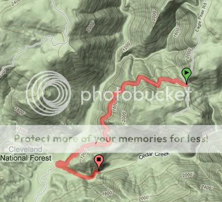
Directions: Drive to Pine Hills Road, which intersects Highway 78 about 1 mile west of Julian, and turn south. After 1.5 miles on Pine Hills Road, bear right on Eagle Peak Road. After 1.4 more miles, veer right again, staying on Eagle Peak Road. Next comes 8.2 miles of progressively poorer dirt road, parts of which become slippery and muddy in wet weather. At the end, you come to the Cedar Creek Falls trail head (Adventure Pass required by the US Forest Service on all national forest land).
Date: Sat. Jan. 1st, 2011
Meeting Location: Dudley's Bakery - 30218 California 78 Santa Ysabel, CA 92070
Meeting Time: 7:00am
Perhaps San Diego County's most spectacular waterfall, Cedar Creek Falls should be roaring with all the recent rains we've had here. Plunging about 90ft into a large pool surrounded by rock walls, it's one of the more popular hikes in this part of California, which can be fairly pretty rigorous. Wear good hiking boot, and bring lots of water.
The 4.5 mile round trip hike is open and exposed to the sun the basically the entire time. You do get a good view of Mildred Falls on the opposite side of the valley. The vertical gain/loss of this hike is about 1200 ft. During the summer many people severely underestimate this trip. Over the past year more than a dozen people were rescued, some by helicopter, along the trail. However, for this time of the year we can expect pleasant temperatures.
Latitude: 32.989876
Longitude: -116.729822
Directions: Drive to Pine Hills Road, which intersects Highway 78 about 1 mile west of Julian, and turn south. After 1.5 miles on Pine Hills Road, bear right on Eagle Peak Road. After 1.4 more miles, veer right again, staying on Eagle Peak Road. Next comes 8.2 miles of progressively poorer dirt road, parts of which become slippery and muddy in wet weather. At the end, you come to the Cedar Creek Falls trail head (Adventure Pass required by the US Forest Service on all national forest land).
Date: Sat. Jan. 1st, 2011
Meeting Location: Dudley's Bakery - 30218 California 78 Santa Ysabel, CA 92070
Meeting Time: 7:00am