July 14, 2011 Map & Compass
Posted: Tue Jul 12, 2011 9:19 pm
Map and Compass is a difficult subject to discuss without visual aids. We'll do our best on Thursday to exchange ideas.
Map & Compass Goals
1) To know where you are.
2) To be able to tell others where you are.
3) To know where others are when they describe their location to you.
4) To be able to find a route to a location
5) To be able to project an azimuth and calculate distance to a landmark
Map Projection - A map projection is a way to represent the curved surface of the Earth on a flat surface. A good globe can provide the most accurate representation of the Earth. However, a globe isn't practical for many of the functions for which we require maps. Map projections allow us to represent some or all of the Earth's surface, at a wide variety of scales, on a flat, easily transportable surface, such as a sheet of paper. For more info on map projections: http://en.wikipedia.org/wiki/Map_projection
Topographical Map – A topographical map (Topo) uses contour lines to show relief. http://topomaps.usgs.gov/
I recommend the following page for more information on topo maps: http://homepages.ius.edu/pgalvin/g333/H ... 20Maps.htm
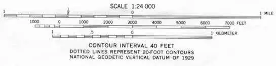
Map Scale - The scale of the map is determined by the amount of area covered by the map. 1:24,000 is a typical scale. This type of scale is known as a ratio scale and what it means is that one inch on the map is equal to 24,000 inches (or 2000 ft) in the real world. Actually, it means that one of anything on the map is equal to 24,000 of the same thing on the map, Another way of phrasing it would be that everything on the map has been reduced to 1/24,000th of their original size.
Minute - A minute is a unit of measurement of time or of angle. In a full circle there are 360 degrees. Each degree is split up into 60 parts, each part being 1/60 of a degree. These parts are called minutes. One minute at the Earth's equator is one nautical mile.
7-1/2 Minute Quadrangle – Originally the USGS produced 15 minute maps but the scale was too small to be practical. The USGS decided to quarter the 15 minute maps creating the maps we use today, the “7-1/2 minute quad map” The earth is divided up into slices measuring from the center of the earth out 7-1/2 minutes in both the North-South direction as well as the East-West direction. At the equator these minutes are exactly the same distance. As you move away from the equator the maps stay the same height while getting narrower.
Contour Interval – Contour interval is the distance between contour lines. On a USGS 7-1/2 minute quad map of a mountainous area the contour interval is normally 40 feet between the contour lines. If we used that same scale on a desert area we may not have many contour lines on the map. For desert areas the contour interval could be 20 feet between contour lines or even less. Some counties in Florida have less than 6’ elevation difference in the whole county. They use a contour interval of 1 foot. The most important thing to remember is that CLOSE contour lines mean STEEP terrain and OPEN contour lines mean FLAT terrain. Every fifth contour line is an index contour. The index contours are bolder and have the elevation marked every so often.
Features & Symbols – USGS topo maps can have up to 60+ layers of features and symbols that can be added. http://egsc.usgs.gov/isb/pubs/booklets/symbols/
Understanding the compass
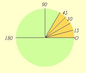
The compass is a device that has an arrow that aligns itself with the local lines of magnetic flux of the earth. An angle of direction is marked in a circle around the compass needle. The method of describing direction that we will be discussing tonight is “Azimuth System” The Azimuth System is an angular measurement in a spherical coordinate system. The vector from an observer (origin) to a point of interest is projected perpendicularly onto a reference plane; the angle between the projected vector and a reference vector on the reference plane is called the azimuth. Even though we use the term “bearing” interchangeably with azimuth they really have different meanings.
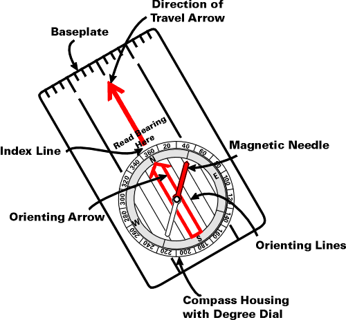
Parts of a compass
The compass needle points parallel to the local lines of magnetic flux
The compass housing can be turned to set a direction of travel or to measure an angle
The compass has an orienting arrow. You “box” the compass needle inside this orienting arrow to set your direction of travel. It can also be used to measure angles on a map
There are 2 or 4 orienting lines that are parallel to the orienting arrow. They can also be used to measure angles on a map
The direction of travel arrow points to your direction of travel
The many purposes of the compass
A good compass is more than just a direction pointer. A good compass should have the following capabilities:
It points to the magnetic North Pole
It points to geographic or map North
It has scales for measuring length
It has map scales for measuring distances
It can be used as a straight edge
It can be used as a protractor
IMO you want a compass that meets the above criteria and is liquid filled and has the capability for manually correcting for declination.
Some compasses can also be used for:
Determining slope
Measuring the height of objects
UTM grid measurement
A signal mirror (a sighting mirror doubles the accuracy of a compass)
There are 3 Norths
Grid North or Map North: The direction your map is oriented to. The left and right margins of your map are Grid North.
True North: the direction of a meridian of longitude which converges on the North Pole.
Magnetic North: the direction indicated by a magnetic compass. Magnetic North moves slowly with a variable rate.
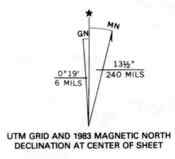
For land navigation we do not concern ourselves with any difference between grid north and true north as they are less than 1° difference.
For land navigation we must concern ourselves with the difference between Map North and Magnetic North. This difference is called DECLINATION. The declination locally is approximately 14°
There are 2 ways to compensate for declination.
1) Manually – your compass has the ability to manually adjust for declination
2) Arithmetic-users of compasses that do not have manual declination compensation capability can use arithmetic to compensate.
2a) From map to compass: West declinations are added. East declinations are subtracted
2b) From compass to map: West declinations are subtracted. East declinations are added
Using a map and compass together
By setting your compass to North and boxing the compass needle inside the orienting arrow and then setting your compass on the map you can orient your map so that it is facing North
You can use your compass as a protractor to accurately draw lines on your map to any azimuth. This is very handy in triangulating landmarks to ascertain a position and in projecting azimuths.
You can use the ruler on your compass to measure distances on your map.
Map & Compass Goals
1) To know where you are.
2) To be able to tell others where you are.
3) To know where others are when they describe their location to you.
4) To be able to find a route to a location
5) To be able to project an azimuth and calculate distance to a landmark
Map Projection - A map projection is a way to represent the curved surface of the Earth on a flat surface. A good globe can provide the most accurate representation of the Earth. However, a globe isn't practical for many of the functions for which we require maps. Map projections allow us to represent some or all of the Earth's surface, at a wide variety of scales, on a flat, easily transportable surface, such as a sheet of paper. For more info on map projections: http://en.wikipedia.org/wiki/Map_projection
Topographical Map – A topographical map (Topo) uses contour lines to show relief. http://topomaps.usgs.gov/
I recommend the following page for more information on topo maps: http://homepages.ius.edu/pgalvin/g333/H ... 20Maps.htm
Map Scale - The scale of the map is determined by the amount of area covered by the map. 1:24,000 is a typical scale. This type of scale is known as a ratio scale and what it means is that one inch on the map is equal to 24,000 inches (or 2000 ft) in the real world. Actually, it means that one of anything on the map is equal to 24,000 of the same thing on the map, Another way of phrasing it would be that everything on the map has been reduced to 1/24,000th of their original size.
Minute - A minute is a unit of measurement of time or of angle. In a full circle there are 360 degrees. Each degree is split up into 60 parts, each part being 1/60 of a degree. These parts are called minutes. One minute at the Earth's equator is one nautical mile.
7-1/2 Minute Quadrangle – Originally the USGS produced 15 minute maps but the scale was too small to be practical. The USGS decided to quarter the 15 minute maps creating the maps we use today, the “7-1/2 minute quad map” The earth is divided up into slices measuring from the center of the earth out 7-1/2 minutes in both the North-South direction as well as the East-West direction. At the equator these minutes are exactly the same distance. As you move away from the equator the maps stay the same height while getting narrower.
Contour Interval – Contour interval is the distance between contour lines. On a USGS 7-1/2 minute quad map of a mountainous area the contour interval is normally 40 feet between the contour lines. If we used that same scale on a desert area we may not have many contour lines on the map. For desert areas the contour interval could be 20 feet between contour lines or even less. Some counties in Florida have less than 6’ elevation difference in the whole county. They use a contour interval of 1 foot. The most important thing to remember is that CLOSE contour lines mean STEEP terrain and OPEN contour lines mean FLAT terrain. Every fifth contour line is an index contour. The index contours are bolder and have the elevation marked every so often.
Features & Symbols – USGS topo maps can have up to 60+ layers of features and symbols that can be added. http://egsc.usgs.gov/isb/pubs/booklets/symbols/
Understanding the compass
The compass is a device that has an arrow that aligns itself with the local lines of magnetic flux of the earth. An angle of direction is marked in a circle around the compass needle. The method of describing direction that we will be discussing tonight is “Azimuth System” The Azimuth System is an angular measurement in a spherical coordinate system. The vector from an observer (origin) to a point of interest is projected perpendicularly onto a reference plane; the angle between the projected vector and a reference vector on the reference plane is called the azimuth. Even though we use the term “bearing” interchangeably with azimuth they really have different meanings.
Parts of a compass
The compass needle points parallel to the local lines of magnetic flux
The compass housing can be turned to set a direction of travel or to measure an angle
The compass has an orienting arrow. You “box” the compass needle inside this orienting arrow to set your direction of travel. It can also be used to measure angles on a map
There are 2 or 4 orienting lines that are parallel to the orienting arrow. They can also be used to measure angles on a map
The direction of travel arrow points to your direction of travel
The many purposes of the compass
A good compass is more than just a direction pointer. A good compass should have the following capabilities:
It points to the magnetic North Pole
It points to geographic or map North
It has scales for measuring length
It has map scales for measuring distances
It can be used as a straight edge
It can be used as a protractor
IMO you want a compass that meets the above criteria and is liquid filled and has the capability for manually correcting for declination.
Some compasses can also be used for:
Determining slope
Measuring the height of objects
UTM grid measurement
A signal mirror (a sighting mirror doubles the accuracy of a compass)
There are 3 Norths
Grid North or Map North: The direction your map is oriented to. The left and right margins of your map are Grid North.
True North: the direction of a meridian of longitude which converges on the North Pole.
Magnetic North: the direction indicated by a magnetic compass. Magnetic North moves slowly with a variable rate.
For land navigation we do not concern ourselves with any difference between grid north and true north as they are less than 1° difference.
For land navigation we must concern ourselves with the difference between Map North and Magnetic North. This difference is called DECLINATION. The declination locally is approximately 14°
There are 2 ways to compensate for declination.
1) Manually – your compass has the ability to manually adjust for declination
2) Arithmetic-users of compasses that do not have manual declination compensation capability can use arithmetic to compensate.
2a) From map to compass: West declinations are added. East declinations are subtracted
2b) From compass to map: West declinations are subtracted. East declinations are added
Using a map and compass together
By setting your compass to North and boxing the compass needle inside the orienting arrow and then setting your compass on the map you can orient your map so that it is facing North
You can use your compass as a protractor to accurately draw lines on your map to any azimuth. This is very handy in triangulating landmarks to ascertain a position and in projecting azimuths.
You can use the ruler on your compass to measure distances on your map.