The Pinyon Mountain Trail is a great day trip in Southern California, or a destination trail if coming from out of town. The trail is suitable for Fall, Winter, and Spring, with Spring being fantastic if you can time it to catch the flowers. Summer is sketchy due to the extreme heat and should generally be avoided.
The trail is generally Easy, with the exception of two Difficult sections that total about 130 yards out of the 8 mile trail. The Difficult sections amount to just 1.2% of the trail length, but can be a stopper for many vehicles and/or drivers.
Trail Map
The trail is best run from the West to the East. The first 7 miles of trail consists of dirt road that meanders through a Pinyon and Juniper forested desert while on a gentle ascent into the hills. Four wheel drive is generally not needed in this stretch, though I suppose a few soft spots could impede some two wheel drive vehicles with inexperienced drivers. In the Spring, this area displays abundant flowers, and the Juniper/Pinyon forest smell is amazing in the morning especially...Go slow and windows down to take it in.
- Trail Map - Pinyon Mountain Trail
- Pinyon Mountain Trail - Squeeze and Heart Attack Hill.JPG (128.2 KiB) Viewed 1793 times
The Squeeze
The first obstacle on the route is known as The Squeeze, and is maybe 25 yards long at about the 7 mile mark. The trick here is to squeeze through a notch between two rocky hillsides, and do it while descending a rocky, off-camber ladder drop of maybe 6 feet. Going through this notch from West to East in a Jeep TJ is doable without body damage if one drives slow and carefully, and a good spotter helps. Wider vehicles like the Jeep JK are a very tight fit, but I've seen them go through without a scratch with a good driver and spotter. This is not a good trip for running wheel spacers!!. West to East is important, as trying to climb back through The Squeeze is Difficult +.
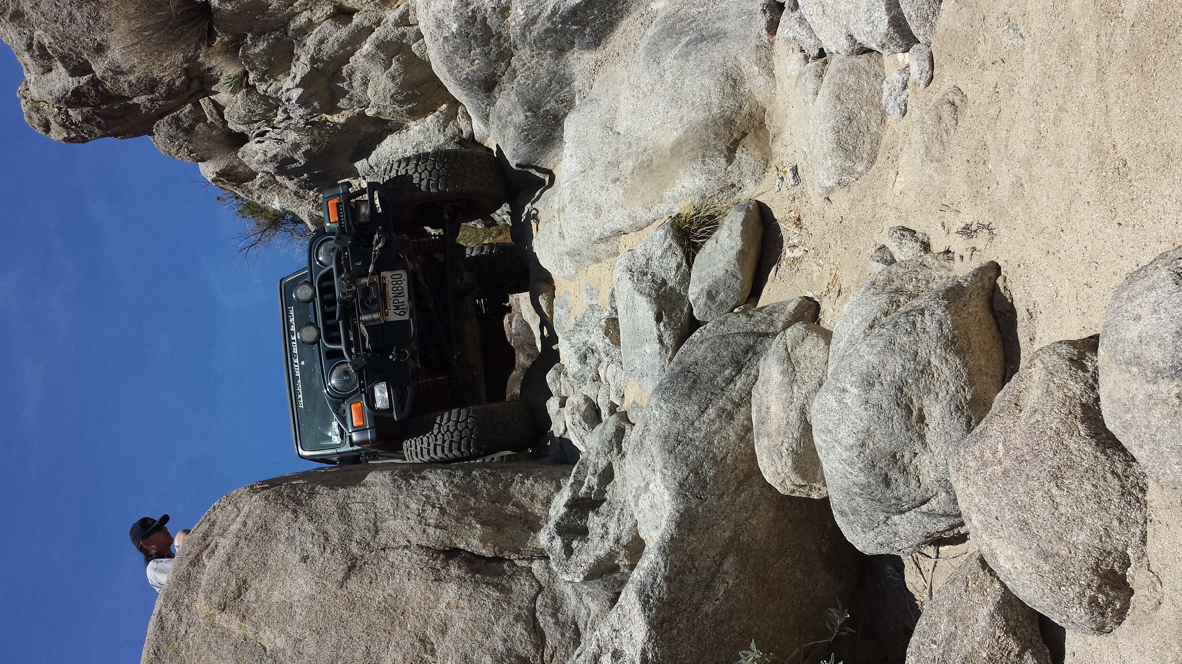
- The Squeeze in a Jeep TJ
- 20140517_114812 - Copy.jpg (6.02 MiB) Viewed 1793 times
Heart Attack Hill
The second obstacle on the route is known as Heart Attack Hill, and is maybe 105 yards long at about the 7.5 mile mark. Heart Attack Hill is a long, steep (70%) downgrade over an eroded granitic surface. To start the descent, one has two options when going West to East, and that his left or right. The left approach requires the driver and vehicle to straddle a deep rut, such that the axle pumpkin can easily get to be 8 feet above the bottom of the rut. Driver caution is required to create enough friction to keep the vehicle from slipping into the rut...of course, this is all done while seeing nothing but blue sky through the windshield due to the slight approach incline. Once the vehicle breaks over the crest and begins the steep, 70% average grade, the driver encounters a 2 foot down step. Getting across the down step requires consistent forward motion as stopping the wheels from turning could easily result in an end-over-end roll. Once down the step, wheel and tire rotation is a must as the eroded granitic surface acts like ball-bearings such that a static tire will slide, resulting in loss of vehicle control (similar to driving on ice). From this point, the job is to keep the vehicle moving and pointed down the hill, which ends in a 90 degree turn to the left. The pictures shown don't do the real life experience justice.

- Heart Attack Hill - Jeep at the Breakover
- Heart Attack Hill - Jeep SD4WDC.jpg (67.5 KiB) Viewed 1790 times
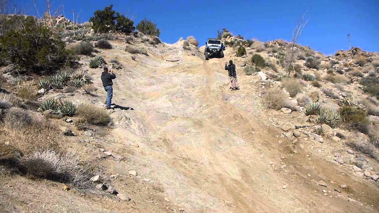
- Heart Attack Hill
- Heart Attack Hill - Jeep on Down Grade.jpg (149.18 KiB) Viewed 1790 times
The Pinyon Mountain Trail ends about a half mile from Heart Attack Hill at Fish Creek (Sand Hooks are the best rigging for Fish Creek).
From the trail end, its about 20 miles of driving sandy dirt roads that follow canyons down towards the desert floor and finally pavement. Don't underestimate these "dry" canyons...they are subject to flash flooding and must be avoided when rain is anywhere in the area. There are long stretches where there is literally no place to get out of the way of a flash flood wave if one were to be in the wrong spot at the wrong time.
Why take this trip:
1. Beautiful scenery.
2. See a wide variety of Anza Borrego Desert terrain and vegetation.
3. Great back roads...but be prepared for The Squeeze and Heart Attack Hill. Traveling West to East, going through The Squeeze commits you to Heart Attack Hill.
4. A nice day trip from start to end with plenty of time to stop and smell the Junipers and take photos.