Map and Compass: Equipment Familiarization, Care and Serviceability:
What are you looking to accomplish? What defines success? Does the equipment, your experience and knowledge for a successful deployment meet your expectations? If the nexus of these questions does not give you a resounding "I can do this and not risk becoming a casualty, lost or worse, place myself in a survival situation that I cannot recover from...for example, death." If you can reduce and mitigate your risks to a manageable level then continue but if you cannot dial back the risks then stop, do not pass go, return to base, realizing earlier is better than late, too late.
NOTE: This is not a discussion of field expedient methods for finding direction but if it were there are several ways to do this and I consider them valuable skills to understand and be able to fall back on.
CARE:
https://classroom.synonym.com/how-to-ca ... 75093.html
- The magnetic compass has been around for hundreds of years. Historically, sailors found compasses particularly useful at night when clouds blocked the stars. Magnetic compasses are still popular today and are used by hikers and sailors. Proper care will keep a compass functioning for many years.
- Store a magnetic compass away from computers and other electrical devices that can generate magnetic fields. Exposure to magnetic fields can damage a compass.
- Keep a magnetic compass away from heaters and do not store in a hot place such as a car. Heat can damage the inner workings of a magnetic compass, resulting in poor performance.
- Carry a magnetic compass so it does not come in contact with cell phones or pocket radios. Store the cell phone or radio in an adjacent pocket or a pocket in a jacket. The speakers in cell phones and other devices can demagnetize the needle on the compass.
- Avoid dropping or bumping the compass on a hard surface. Dropping or bumping the compass may damage it and impair its ability to function correctly.
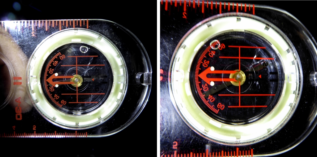
- Exam your compass for bubbles, binding of the needle, cracks and any general issues that will cause this precision instrument to not function as intended.
- 201105, Defective Compass 01.jpg (402.9 KiB) Viewed 1275 times
Checking the accuracy of your compass:
- Nothing like shooting an azimuth to a known point and checking it against mapping programs or your map. If you have several compasses, find a nonferrous post and put the edge of your compass along this straight edge and look for variances between your repertoire of equipment.
Out of the chute you need to understand your equipment and make sure you have the right equipment for the job. Let's talk about making the right equipment choice, the compass and care of equipment:
There are many forms of compasses but we will focus on the most commonly used in the field for general navigation with a heavy focus on the hiking or orienteering aspect.
o
Base Plate compass: A magnetic compass that is set into a clear base that lends itself to easily view a map through the base as different features of the compass are being used in conjunction with a map. "Sighing" on distant objects is not easily done with this style compass like the sighting and lensatic compasses.
o
Sighting compass: A magnetic compass that often relies on a mirror to line up both the bearing and a distant object that is on course and used as a reference point to move to.
o
Lensatic compass: A magnetic compass that can also be called a military or "military style" compass that relies heavily on "sighting" in on a distant object for reference.
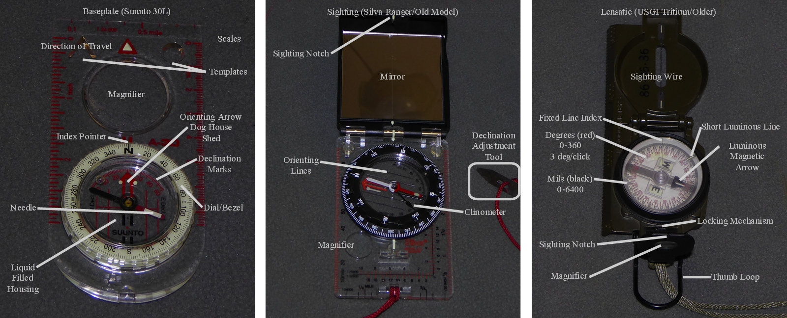
- Base, Sighting and Lensatic or Military Compasses with labels.
- 201101, Compass Choices Combined Labeled 1600 01.jpg (781.92 KiB) Viewed 1383 times
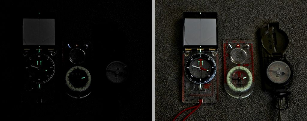
- An example of the "low light" qualities of the big three with phosphorescent vs. tritium.
- 201105, Low Light 1024 04_Detail.jpg (70.37 KiB) Viewed 1379 times
NOTE: Unfair advantage to the phosphorescent compasses due to the age of my military compass, 1984.
o Secondary/Alternative tools include but are not limited to phone (app), wristwatch, GPS and the always present "gimmick" formats. These tools can and should be carried as an alternative but I would hesitate to say I would consider them my primary navigation tool.
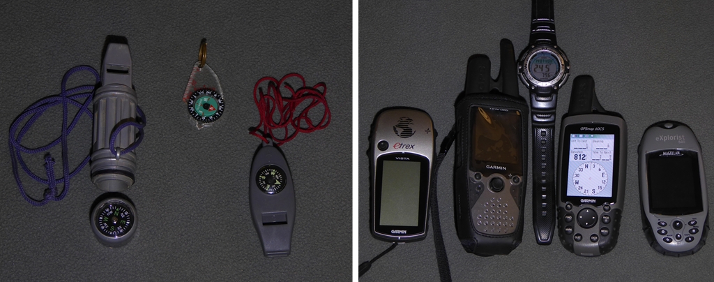
- Secondary means of maintaining an azimuth/bearing.
- 201105, Alternatives Combined 1024 01.jpg (327.62 KiB) Viewed 1381 times
Honorable Mention for the confident and experienced navigator: Suunto M9 Wrist Compass (the exception to the rule)
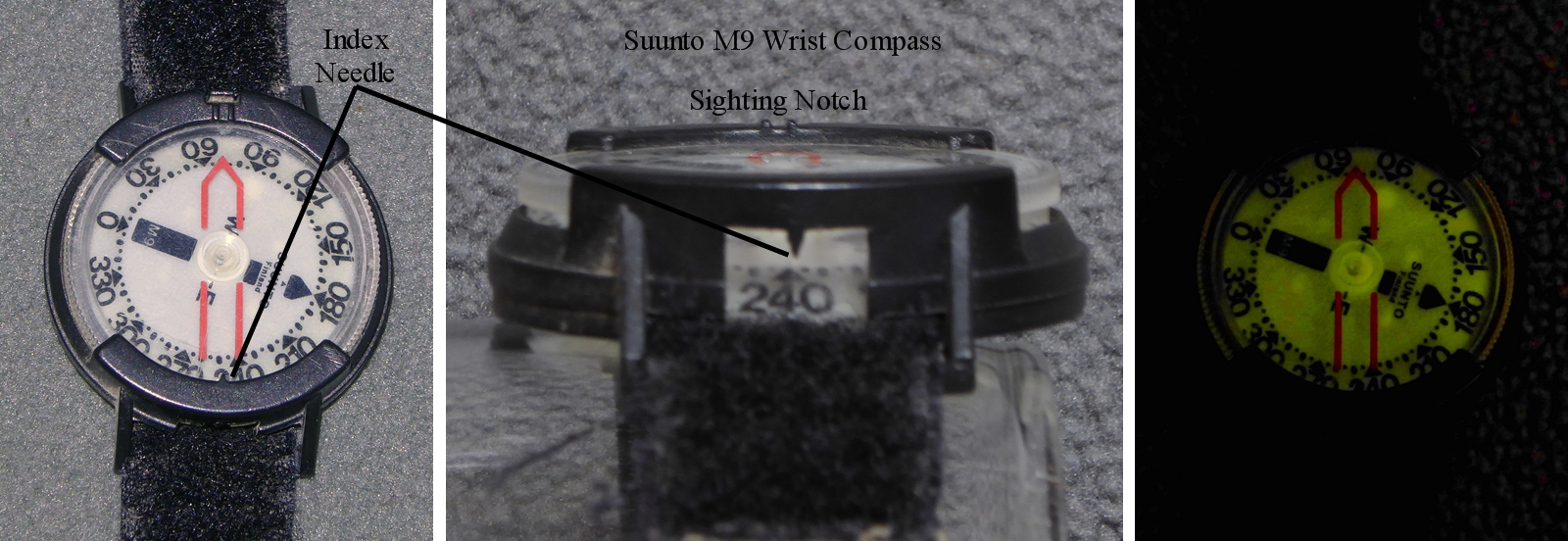
- This is the only "secondary" compass I would elevate to "primary" where the technical aspects of navigation are "intermediate" or "low."
- 201105, Suunto Wrist Labeled 1600 01.jpg (650.54 KiB) Viewed 1381 times
The map, protractor and management of resources:
o
Maps:
-Topographic Maps: Digital or Paper?
- The USGS (https://viewer.nationalmap.gov/basic/) and National Geographic (https://www.natgeomaps.com/trail-maps/pdf-quads) sites are where I go habitually for digital maps. I have not ordered paper maps off line but I have been pretty successful with my gazetteer and home printed maps in black and white from home. I do not see myself buying a lot of pre-printed maps because I use downloaded maps or I bought them from local vendors when they were more readily available. This is a disadvantage for most who are newer to reading a map and suggest a paper map over any other kind of map you might use (having all the colors printed on quality paper makes a big difference). A larger scale map, greater than 1:50,000 is good for generalized navigation but smaller than or equal to 1:50,000 becomes ideal for most general hiking and driving opportunities. For more technical hikes, of course, the 1:24,000 forestry maps are of favorable accuracy and very helpful.
- I will admit, this leaves a lot in the discussion for interpretation for "where to get maps" and since I am not the subject matter expert here I will defer that to another member or participant. Hopefully the bulk of the discussion will help you, once you get a paper map in your hands, to become much more effective when armed with a map and compass.
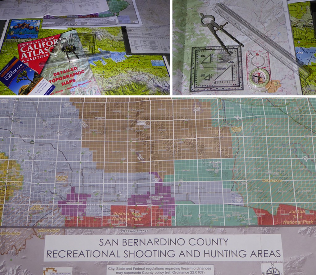
- There are several different kinds of maps and there are tools that make working with maps a lot easier.
- 201105, Map and Tools 1024 01.JPG (304.53 KiB) Viewed 1372 times
- Maps usually contain marginal data that is critical to successful planning and working through the field work where boots met the trail.
- 201105, Map and Tools 1024 02.JPG (313.24 KiB) Viewed 1372 times
o Protractor and Resources:
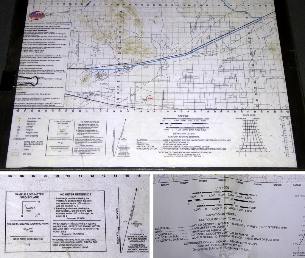
There are other tools that make map work a little easier. A
protractor to determine azimuth on the map (don't forget to account for both the
map datum and the
declination). A
compass to draw circles or measure distances. A
ruler to draw lines and also measure distances. Then there is the need to have your maps on hand when you need them and also a means to protect the maps when taking them to the field. Maps made from water proofed materials are really durable, the National Geographic maps are a great example. Map cases can be made and found for paper maps and the real important part of map management is understanding map folding is an art that needs to leave enough to work with while enough excess that allows for you to see the big picture. Cutting a map down, especially deleting the
marginal information should be avoided. The marginal information is critical if not during the current trip, then definitely the next time you pickup the map next time.
A good, soft lead, thin (mehcanical?) pencil is great for paper map marking and a soft gummy eraser will definitely help to clear unwanted marks. Additionally, if using a laminated map, map case or a map board alcohol markers with fine, medium at best, tips should be used and having prepacked alcohol wipes you rotate out of your medical kits to wipe away marks when you are done is a great way to "mark away" and then clean up when done.
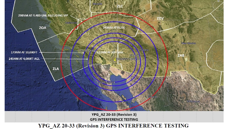
NOTE: A true example of the potential of not being able to depend on your GPS when the government works on an exercise like this. Most ground-bound enthusiasts would not know about this advisory before they head out to the field.
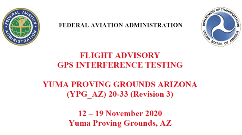
- This is exactly why you have to be very careful to become solely dependent on GPS systems.
- 201112-19, GPS Flight Warning 01.jpg (155.12 KiB) Viewed 1142 times
- Effected area, 11/09-11/12/20.
- 201112-19, GPS Flight Warning 02.jpg (334.88 KiB) Viewed 1142 times