Page 1 of 2

OAUSA Net - July 28, 2022 - 5 Minute Destinations

Posted: Mon Jul 25, 2022 3:20 pm
by DaveK
5 Minute Destinations

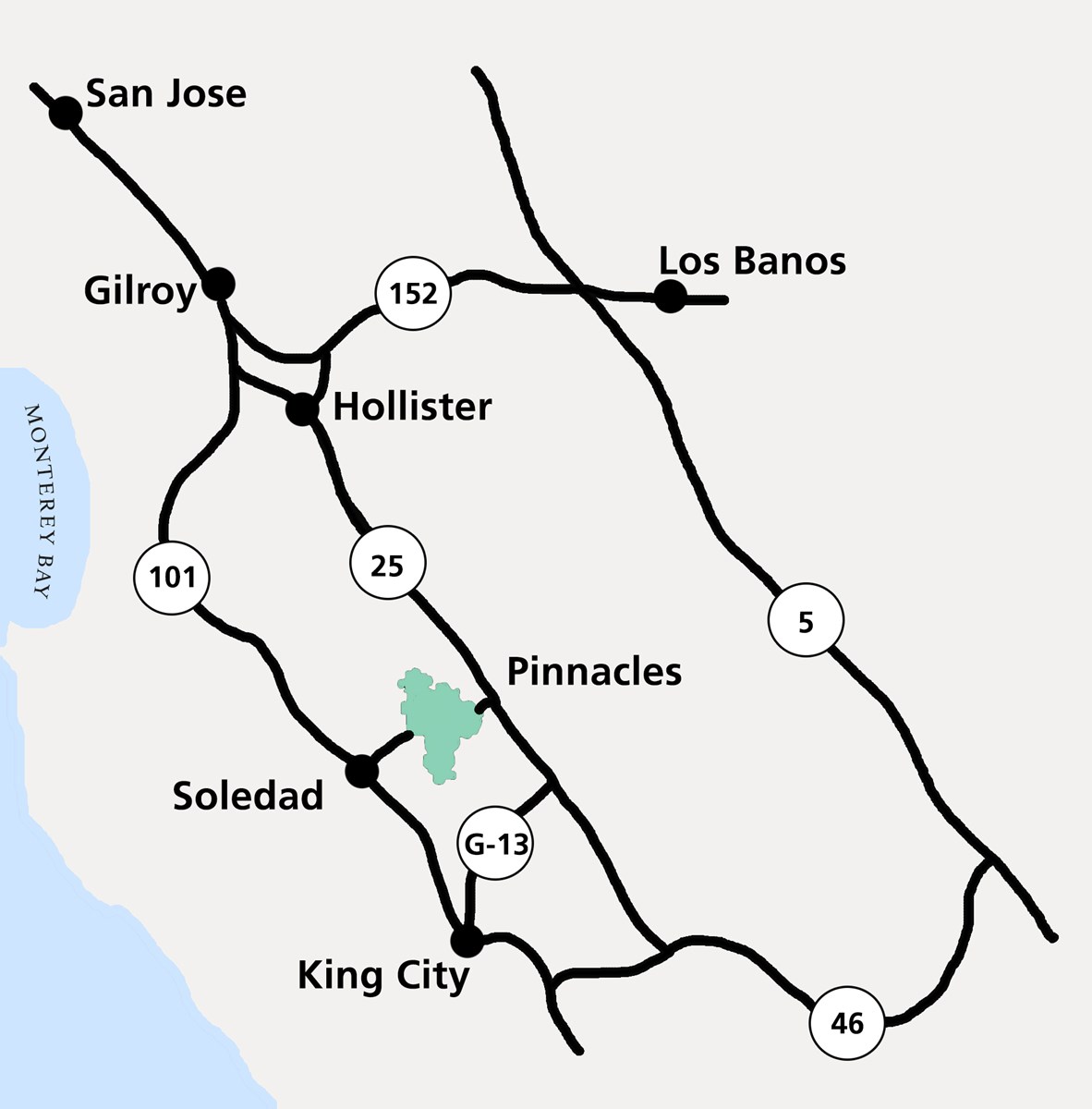
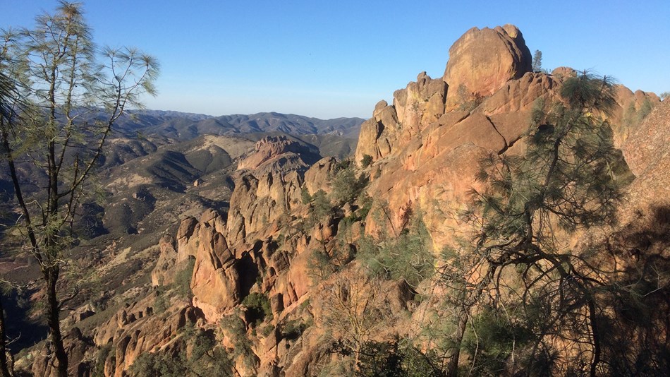
Here we are in the middle of the vacation season. In the Southwest, the weather is beautiful, the days are long, and the opportunities abound to visit some of the best locations in the world. The net this week will be a great opportunity to get some ideas on where to get away. The "5 Minute" idea is our way of getting as many participants as possible, as they each have 5 minutes for their adventure. To get the most out of your 5 minute destination, we encourage everyone to post information and pictures. Don't be shy - if you have a favorite camping spot, hiking adventure, hunting trip, river rafting trip, 4 wheel drive adventure, or sky diving trip, post up with a description and pictures. Also, join us on the net.

One of my favorites:

KC2.JPG
KC2.JPG (185.9 KiB) Viewed 747 times
KC3.JPG
KC3.JPG (214 KiB) Viewed 747 times
IMG_0238 (Medium).JPG
IMG_0238 (Medium).JPG (147.62 KiB) Viewed 747 times
IMG_0210 (Medium).JPG
IMG_0210 (Medium).JPG (77.07 KiB) Viewed 747 times
IMG_0710 (Large).JPG
IMG_0710 (Large).JPG (183.3 KiB) Viewed 747 times

Re: OAUSA Net - July 28, 2022 - 5 Minute Destinations

Posted: Wed Jul 27, 2022 8:19 am
by toms
Rasor Off-Highway Vehicle Area

The Rasor OHV is sandwiched between the western edge of the Mojave National Preserve and Afton Canyon. Most people access the area from I-15 at the Rasor Road exit (between Barstow and Baker, CA).

Map - Rasor OHV.JPG
Map - Rasor OHV.JPG (73.12 KiB) Viewed 719 times
The BLM Desert Access map cost $4.00. The big red line is the Mojave Road cutting through Rasor OHV. The Thin brown/red line on the north is I-15


Rasor OHV is an open riding area. As long as you are inside the OHV cross country vehicle travel is permitted. Camping is allowed anywhere in the open area. On long holiday weekends, expect to see plenty of campers and toy haulers. There is no shooting allowed and no glass beverage bottles are allowed (empty or not!).

If you stay on Rasor road until it ends at the border of the Mojave National Preserve, you will reach the ruins of Rasor Station of the now defunct Tonopah and Tidewater Railroad (T&T). It was named for Clarence Rasor who was the chief engineer (Palazzo, 2011). All that is left of the ghost station master’s house, bunkhouse, toolshed and water tank are the foundations. It is a popular camp spot today with several shade trees.
Site of old T&T Rasor Station.JPG
Site of old T&T Rasor Station.JPG (44.32 KiB) Viewed 719 times
Camp at site of T&T Rasor station.JPG
Camp at site of T&T Rasor station.JPG (66.47 KiB) Viewed 719 times
The Old Mojave Road cuts through the middle of the OHV on its way from the Colorado River to the Coast.
Half or more of the OHV is in the Mojave River Floodplain.

The dividing line is Shaw Pass over the Soda Mountains. Shaw Pass was named for Army Surgeon Dr. Shaw. Accompanied by a soldier who was carrying the US mail, he was killed by an Indian arrow through the neck while traveling this section of the Mojave road in October 1867. Shaw is buried at Soda Springs, the location of current day ZZYZX, CA (Casebier).
Mojave Road toward Shaw Pass.JPG
Mojave Road toward Shaw Pass.JPG (60.98 KiB) Viewed 719 times
Looking west on the Mojave Road, Shaw pass is in the V defined by the mountain range.

The heavy sand that blows from the Mojave Flood plane is a major attraction for off road use. The area has a number of small dunes. Somewhat hidden to the southwest is one major sand bowl that can provide hours of fun.
Big sand bowl.JPG
Big sand bowl.JPG (45.43 KiB) Viewed 719 times
This large dune is hidden by the mountain that helped create it.


The Union Pacific railroad tracks form the southern border. West along the tracks toward Afton Canyon, is the old railroad watering stop of King. There are no ruins left except the grave site of Delores Holland. The daughter of a railroad worker, she died as an infant in 1931. Some distant relatives maintain the site and decorate it for each holiday (Mann, 2004).
Train.JPG
Train.JPG (65.07 KiB) Viewed 719 times
Delores Holland Grave site.JPG
Delores Holland Grave site.JPG (47.33 KiB) Viewed 719 times
Dolores Holland’s grave at the old King railroad watering station with Cave Mountain in the background.


The bed of the old T&T Railroad forms the Southeastern boundary of the OHV area and the Mojave National Preserve. Just beyond the Rasor Station, you can find the old T&T RR bed.

The remote Rasor OHV might just become your new favorite destination in the desert. Enjoy exploring!

The Pinnacles National Park

Posted: Thu Jul 28, 2022 10:57 am
by Jeff-OAUSA
Pinnacles National Park - 5 Minutes on a Beautiful Destination

General Description
"Pinnacles National Park is an American national park protecting a mountainous area located east of the Salinas Valley in Central California, about five miles (8.0 km) east of Soledad and 80 miles (130 km) southeast of San Jose. The park's namesakes are the eroded leftovers of the western half of an extinct volcano that has moved 200 miles (320 km) from its original location on the San Andreas Fault, embedded in a portion of the California Pacific Coast Ranges. Pinnacles is managed by the National Park Service and the majority of the park is protected as wilderness.

The national park is divided by the rock formations into East and West Divisions, connected only by foot trails. The east side has shade and water, the west has high walls. The rock formations provide for spectacular pinnacles that attract rock climbers. The park features unusual talus caves that house at least 13 species of bats. Pinnacles is most often visited in spring or fall because of the intense heat during the summer. Park lands are prime habitat for prairie falcons, and are a release site for California condors that have been hatched in captivity.

Pinnacles was originally established as a national monument in 1908 by President Theodore Roosevelt, and was redesignated as a national park in 2013." Ref: https://en.wikipedia.org/wiki/Pinnacles_National_Park

Location
Image
Pinnacles Location.jpg
Pinnacles Location.jpg (178.56 KiB) Viewed 682 times
Climate
Pinnacles Climate.jpg
Pinnacles Climate.jpg (269.55 KiB) Viewed 682 times
Why Go?
The park is beautiful, rugged, and, unfortunately, heavily used for the size of the park. Despite the heavy use, if one is willing to hike just a mile from the trailhead, one can easily forget they are close to a lot of other people.

The vehicle-based camping areas are a bit dusty and crowed, though off-season one can find some space. The best camping is up some of the trails in the area.

Sunset
Image

Rock Formations
Image

Talus Caves
Image

Re: OAUSA Net - July 28, 2022 - 5 Minute Destinations

Posted: Thu Jul 28, 2022 12:11 pm
by DaveK
Pinyon Mountain Valley - Anza Borrego Desert State Park

Even considering the vast number visitors to the ABDSP, and the crowded conditions of some of the dirt trails, there still are several places where solitude still exists. And, it should come as no surprise that access to the Valley requires at least a high clearance vehicle, and with the possibility of trail damage from storms, safety suggests that 4WD might be necessary. Anza Borrego is still one of the places where "dispersed camping", is still allowed, meaning that campers are not restricted to established campgrounds.

While the trail to the Pinyon Mt. Valley is not well suited to the family sedan, it is one that has been significantly improved by the park service in recent years (as have many of the other trails in the park, i.e. Coyote Canyon -lower and middle willows.) Even the remaining difficulty of this trail contributes to the solitude that campers can still enjoy. While the trail difficulty is not significant, this is true only until one reaches the "squeeze", which is how many are familiar with this area. With a well equipped and narrow 4WD, piloted by a skilled driver, the "squeeze" can be a white knuckle adventure.

The other contributing factor to the solitude of Pinyon Mtn. Valley is the long spur trails that lead to several great camping areas. In some cases, these spur trails are far enough away that other vehicles are not even visible while at camp. And, there are no camping fees and no camp hosts or monitors. For those who are willing to take the time to visit this area, dispersed camping will mean that you will need to bring everything your camp requires, as there are no services 0r facilities, of any kind. One note of caution: While camp fires are allowed , the ABDSP rules require that they be in some type of pan - no ground fires. Due to wild fire restrictions, you should check with the Park Service to get current information.

THE TRAIL TO CAMP

KIMG0635.jpg
KIMG0635.jpg (2.18 MiB) Viewed 689 times
KIMG0636.jpg
KIMG0636.jpg (2.51 MiB) Viewed 689 times
KIMG0638.jpg
KIMG0638.jpg (2.95 MiB) Viewed 689 times
On the Trail.jpg
On the Trail.jpg (2 MiB) Viewed 689 times
KIMG0642.jpg
KIMG0642.jpg (2.3 MiB) Viewed 689 times
KIMG0644.jpg
KIMG0644.jpg (1.69 MiB) Viewed 689 times
KIMG0649.jpg
KIMG0649.jpg (1.91 MiB) Viewed 689 times

CAMP

KIMG0630.jpg
KIMG0630.jpg (2.86 MiB) Viewed 690 times
KIMG0623 (Large).jpg
KIMG0623 (Large).jpg (129.8 KiB) Viewed 690 times
KIMG0622 (Large).jpg
KIMG0622 (Large).jpg (114.21 KiB) Viewed 690 times
Resized_20200330_170332.jpg
Resized_20200330_170332.jpg (121.83 KiB) Viewed 690 times
Resized_20200330_170301[1].jpg
Resized_20200330_170301[1].jpg (131.77 KiB) Viewed 689 times
Resized_20200330_154956.jpg
Resized_20200330_154956.jpg (105.05 KiB) Viewed 690 times


VIEWS

KIMG0647.jpg
KIMG0647.jpg (2.35 MiB) Viewed 689 times
KIMG0648 (Large).jpg
KIMG0648 (Large).jpg (183.01 KiB) Viewed 689 times
KIMG0650 (Large).jpg
KIMG0650 (Large).jpg (157.86 KiB) Viewed 689 times
KIMG0651.jpg
KIMG0651.jpg (2.66 MiB) Viewed 689 times
KIMG0655 (Large).jpg
KIMG0655 (Large).jpg (191.99 KiB) Viewed 689 times
KIMG0653.jpg
KIMG0653.jpg (3.96 MiB) Viewed 689 times

Re: OAUSA Net - July 28, 2022 - 5 Minute Destinations

Posted: Thu Jul 28, 2022 5:31 pm
by H380
Please check me in: WY6R -- Bob.

Re: OAUSA Net - July 28, 2022 - 5 Minute Destinations

Posted: Thu Jul 28, 2022 5:50 pm
by KK6DYO
Anza Borrego - Dispersed Camping in Mine Wash

Sometimes you just want to get out for a little camping. While scenic areas are preferable, the main goal is to enjoy the company of friends.

Last November, we made a quick plan to get out for one night, randomly selecting Mine Wash since it wasn't too far off-road. We don't really like established campgrounds, would just as soon not pay the inflated state campground fees, and being a last-minute trip, didn't expect anything to be available on the reservation system anyway.

If you know where Tamarisk Grove Campground is, the Mine Wash turnoff is roughly five miles east on 78 past its intersection with S3. It can be easy to miss. Along Mine Wash is the site of an old Kumeyaay Village. All that's left are morteros (rounded impression in rocks) where nuts and seeds were ground. Traffic to the Kumeyaay Village, while sparse, is enough to keep the wash passable to vehicles.

We selected the general camping area on topographic and satellite maps an area that looked flat behind some hills to block any wind. We rendezvoused using APRS and ham radio. New to the area (hadn't been there in a few years) was a restroom off the wash just after the turnoff.
MineWash.png
MineWash.png (1.17 MiB) Viewed 679 times
We got to the wash well after dark. The Rigid diffused light I have on my roof rack provided plenty of light to follow the narrow wash and find our friends who already set up camp there.


Got up the next morning just as the sun was making its way over the hills.
ABMW2.jpg
ABMW2.jpg (226.05 KiB) Viewed 674 times

360 of area while drinking morning coffee while waiting for others to rise.
360 Morning
ABMW3.jpg
ABMW3.jpg (202.82 KiB) Viewed 674 times

Even in winter, the desert sun can start blasting early in the morning.
ABMW6.jpg
ABMW6.jpg (182.48 KiB) Viewed 674 times

It was warm, so we pretty much hung out while talking during the morning until lunch.
Shaded.jpg
Shaded.jpg (134.69 KiB) Viewed 674 times
360 same picture as above.
360 Hanging Out


We drove into town (Borrego Springs) for a civilized restaurant lunch, about a half hour each way, stopping at some of the metal sculptures in the valley.

I'm not really sure where the day went, but we got back late in the afternoon, and it wasn't long before the winter sun disappeared.


Got some charcoal going for grilling and Dutch oven use.
ABMW4.jpg
ABMW4.jpg (190.96 KiB) Viewed 674 times

I seared a tri-tip over charcoal (previously sous vided). Edible, but my technique needs some work. Also had mixed vegetables.
ABMW7.jpg
ABMW7.jpg (205.66 KiB) Viewed 674 times

While dispersed camping is allowed in Anza Borrego, ground fires are strictly not allowed, thus you must bring some kind of fire pit if you intend on having a campfire during the evening. Scott's trusty stainless washing machine drum always works perfectly.
ABMW5.jpg
ABMW5.jpg (207.27 KiB) Viewed 679 times

The area doesn't always need to be awesome. Just being out, especially with friends, is all that matters.

Re: OAUSA Net - July 28, 2022 - 5 Minute Destinations

Posted: Thu Jul 28, 2022 5:54 pm
by toms
Checking out the Carson & Colorado RR Tunnel
Boundry Peak & Montgomery in back ground from Teals Marsh.jpg
Boundry Peak & Montgomery in back ground from Teals Marsh.jpg (347.74 KiB) Viewed 678 times
Overview

• Good one day trip or combine with others for an overnight
• Only one tunnel in 300 miles of RR
• In the Montgomery Mountains on the CA & NV border
• Turn off is 50 miles from Bishop CA on US 6
• Turn right at N37 58.338 W118 19.785 and look for trail (aka Rail Road bed)
C&C Tunnel Route .jpg
C&C Tunnel Route .jpg (4.24 MiB) Viewed 678 times
History of the Carson & Colorado railroad
The C & C began operation in August 1883. Interestingly it was owned by the Virginia and Truckee RR (V&T) – a short line serving the Comstock mining district in the Carson City and Virginia City NV area.

To save money, it was designed as a narrow gauge (3 ft. wide) railroad. Covering about 300 miles, the railroad ran from Mound House, Nev. to Keeler, Calif. Its primary function was to haul the vast minerals, mainly gold and silver, from the mines in Nevada. It also served the Ranchers and farmers hauling agriculture products to markets in the east.

The rail line climbed to more than 7,100 feet as it worked its way through Montgomery Pass. It is there that engineers cut the only tunnel to maintain about a 2% grade needed for the route. (It is that tunnel that is the focus of a recent expedition.)

The name C&C came from the original plan to build the railroad from the Carson River to the Colorado River.

Southern Pacific purchased the C & C railroad in 1900, and in 1905 converted 140 miles of track in Nevada to standard gauge. Most of that track was abandoned in the 1930s and ’40s. The final run on the narrow-gauge track occurred on April 29, 1960.
Train near tunnel (Courtesy of Eastern California Museum) .jpg
Train near tunnel (Courtesy of Eastern California Museum) .jpg (24.82 KiB) Viewed 678 times


Route to the C & C railroad tunnel
Thanks to Roger Mitchell’s guide book Great Basin SUV Trails Vol. II, I mapped out a route from Bishop, Calif., to the tunnel. [Note: you can reach the start of the trail head from Tonopah, NV also.]
It proved to be just as interesting as I imagined. It’s a relatively short drive (as four wheeling goes), and the trail is in good shape.

The drive from Bishop to the trail head took about an hour. We drove US6 for about 50 miles to a point near [N37 58.338 W118 19.785] where the old railroad bed crosses the highway almost at the top of Montgomery Pass.

Although the trail is in pretty good shape, you definitely need a 4WD vehicle. Driving was smooth overall, though you need to use compression braking while changing grade in the mountain passes

I was continually amazed at the condition of the trail, especially over old washes. Engineers many years ago filled in and leveled those sections. The fill, 10-15 deep in places, was just as solid and stable as the day it was built. It’s a testament to their engineering and construction ability.

The north end of the tunnel is about 2.2 miles in. We were there in 45 minutes. There were some truly awesome views of the White Mountains and Sierra Nevada Mountains on the way in. The tunnel can no longer be safely entered.
Other end of the tunnel.jpg
Other end of the tunnel.jpg (590.93 KiB) Viewed 678 times
By traversing down a steep bypass, we dropped to the lower RR bed as it winds out of the south entrance on the mountain contours. A very short drive put us at the south entrance.
Open end.JPG
Open end.JPG (503.98 KiB) Viewed 678 times
In the Tunnel.jpg
In the Tunnel.jpg (374.96 KiB) Viewed 678 times
We chose not to retrace out path but follow the south bound RR bed until in came out again on the highway.
Total distance to and from the highway was about 4.5 miles. We averaged around 3 mph, so the railroad part of the trip took about 90 minutes. But that includes stops for picture taking and walking around. After returning to the highway, we headed back to Bishop.

Re: OAUSA Net - July 28, 2022 - 5 Minute Destinations

Posted: Thu Jul 28, 2022 7:18 pm
by AK6DH
Check me no in. David - AK6DH.
I have my local ham club meeting tonight.

Re: OAUSA Net - July 28, 2022 - 5 Minute Destinations

Posted: Thu Jul 28, 2022 7:22 pm
by Voodoo Blue 57
Desert Training Center aka: Patton Training Center

The Desert Trainig Center is located between highway 10 and highway 62, and East of highway 177.

Excerpt from Wikipedia: The Desert Training Center (DTC), also known as California–Arizona Maneuver Area (CAMA), was a World War II training facility established in the Mojave Desert and Sonoran Desert, largely in Southern California and Western Arizona in 1942.

Its mission was to train United States Army and Army Air Forces units and personnel to live and fight in the desert, to test and develop suitable equipment, and to develop tactical doctrines, techniques and training methods.

Camp Coxcomb Chapel
Camp Coxcom Chapel 1.jpg
Camp Coxcom Chapel 1.jpg (393.13 KiB) Viewed 660 times
Fox Hole
Foxhole.jpg
Foxhole.jpg (4.41 MiB) Viewed 660 times
Area Map
Screen Shot 2022-07-28 at 7.10.21 PM.png
Screen Shot 2022-07-28 at 7.10.21 PM.png (811.5 KiB) Viewed 660 times
A few of the bunkers found around the DTC
Bunker 4.jpg
Bunker 4.jpg (432.21 KiB) Viewed 660 times
Bunker 5.jpg
Bunker 5.jpg (498.1 KiB) Viewed 660 times
Bunker 6.jpg
Bunker 6.jpg (343.61 KiB) Viewed 660 times
Bunker 7.jpg
Bunker 7.jpg (275.07 KiB) Viewed 660 times
Camp Iron Mountain Chapel
Camp Iron Mountain Chapel.jpg
Camp Iron Mountain Chapel.jpg (159.08 KiB) Viewed 660 times
A couple of relics that can be found within the DTC
Relic 1.jpg
Relic 1.jpg (131.75 KiB) Viewed 660 times
Relic 2.jpg
Relic 2.jpg (278.82 KiB) Viewed 660 times
And finally tank tracks that are still visible today
Tank Tracks.jpg
Tank Tracks.jpg (527.62 KiB) Viewed 660 times

Re: OAUSA Net - July 28, 2022 - 5 Minute Destinations

Posted: Thu Jul 28, 2022 7:26 pm
by Geoff
Please check me in tonight.