Page 1 of 2
OAUSA Net - 8/4/22 - Outback Travel in Earthquake Land
Posted: Tue Aug 02, 2022 9:52 am
by DaveK
Outback Travel in Earthquake Land
Every place in America seems to have it's own unique natural events that present dangers to those who live or recreate there. And, whether its hurricanes, floods, tornadoes, extreme weather, or earthquakes, we know only too well that being prepared is one of the keys to safety. Although earthquakes are more common here in the western US, they still occur in many other parts of the country, albeit with much less frequency and magnitude. The natural movement of the earth's tectonic plates is constant, but they often get stuck due to friction. When the mounting stress on this movement overcomes the friction, it's earthquake time. We haven't had a real good shaker in a while, and current wisdom suggests that a good one is coming.
Many of the areas we visit, and camp, are earthquake prone, and taking take this into consideration should be an important part of part of your trip planning. The net this week will offer a better understanding of this natural event, along with some thoughts on how to be aware of the risks and steps you can take to protect your self. Join us.
Re: OAUSA Net - 8/4/22 - Outback Travel in Earthquake Land
Posted: Tue Aug 02, 2022 5:35 pm
by JackM-KK6WXQ
OVERLANDING IN EARTHQUAKE COUNTRY
California’s sheared-up landscape and earthquake hazards reflect the movement of the Pacific Plate past the edge of North America along a transform plate boundary that extends from the Mexican border to north of San Francisco. This feature includes the famous San Andreas Fault, responsible not only for destructive earthquakes, but also for the spectacular scenery of the San Francisco Bay area and other coastal regions of California. Shown here is a basic fault map of the North American and Pacific Plates.
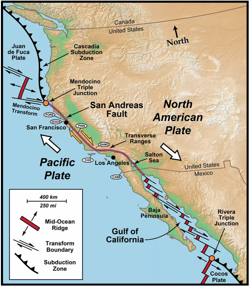
- North America Plate.png (1.09 MiB) Viewed 687 times
San Andreas Card Trick
Deformation along the transform plate boundary in California can be visualized by placing a deck of cards between your hands in a praying position. Imagine that your left hand is the undeformed Pacific Plate, your right hand the intact North American Plate. Notice what happens as you move your left hand away and slide your right hand toward you. The cards slip along their faces, forming a broad zone of shearing between your unaffected hands. For western California, each slipping card face would be a fault surface. The broad zone of transform motion between the Pacific and North American plates formed numerous slivers of mountain ranges with narrow valleys in between. The valleys are commonly due to erosion along individual fault lines. Sometimes the valleys are partially filled with water, as at Point Reyes National Seashore, where Tomales Bay and Olema Valley follow the main trace of the San Andreas Fault.
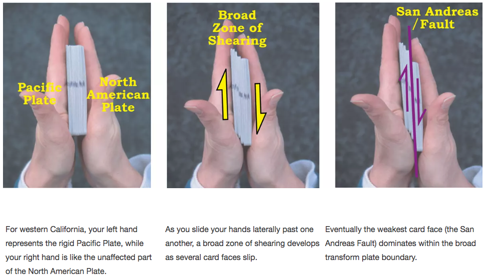
- Card Trick.png (506.53 KiB) Viewed 687 times
“We replicated a highly referenced study that measured the slip rate as 33.9 ± 2.9 mm/year along the San Andreas fault over the past ~3,700 years at Wallace Creek in the Carrizo Plain National Monument, USA”.
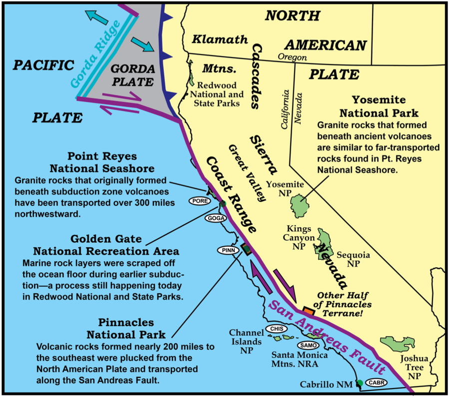
- San Andreas Fault.png (587.23 KiB) Viewed 687 times
- Slip Rate.png (319.34 KiB) Viewed 687 times
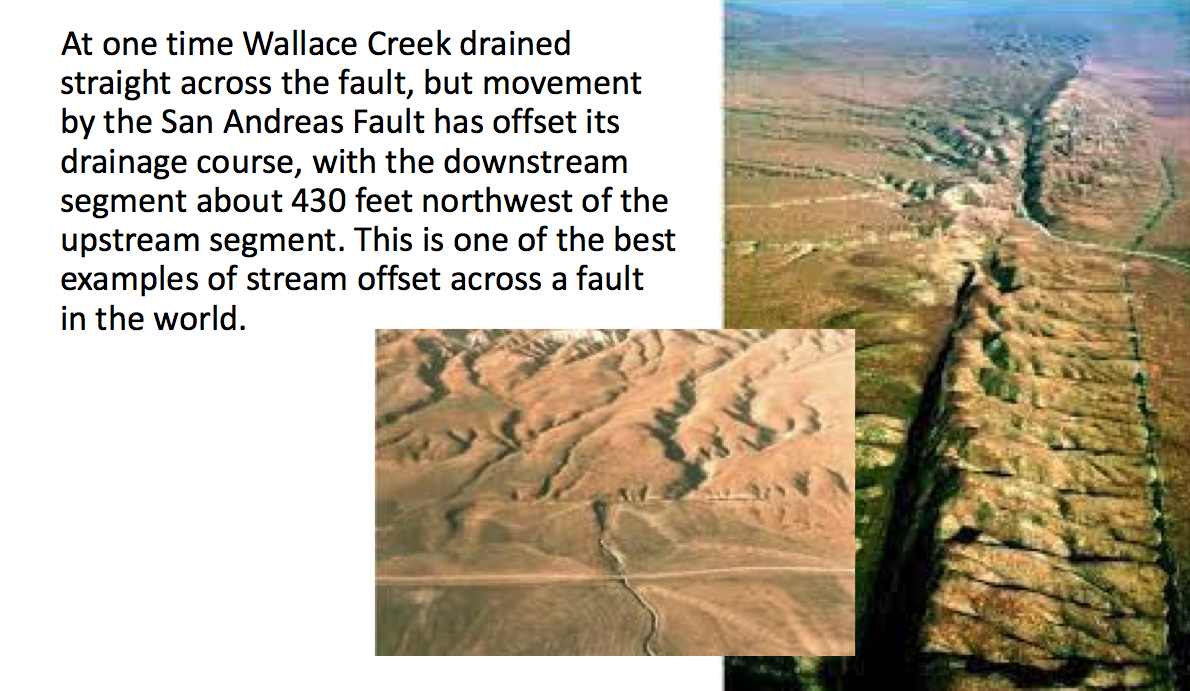
- Wallace Creek.png (876.04 KiB) Viewed 687 times
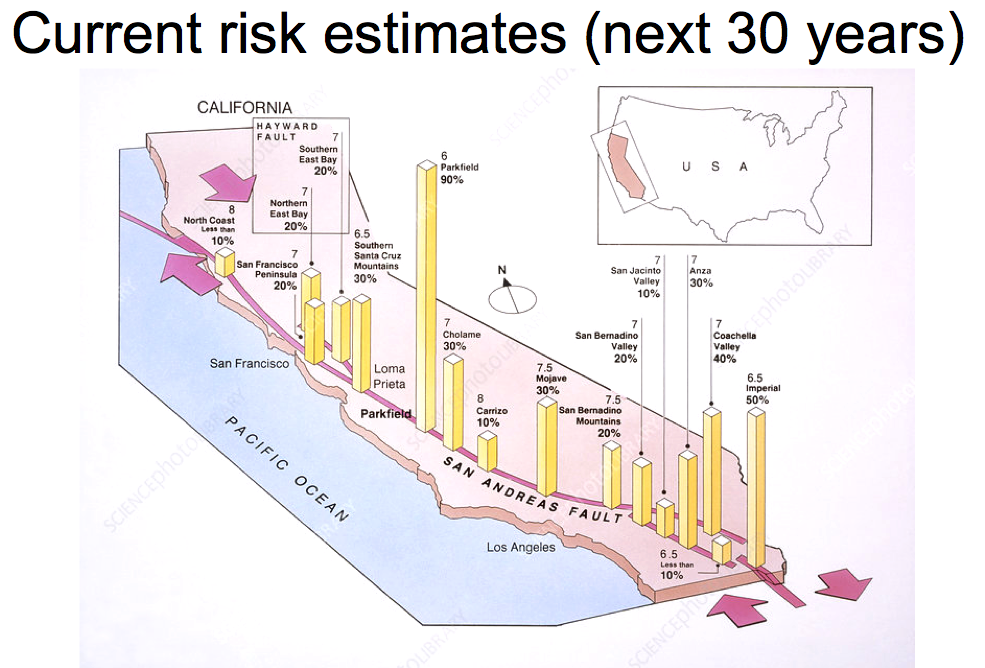
USGS Earthquake Probability
- Current Risk.png (607.52 KiB) Viewed 687 times
Watch the Shake Out Video (just over 2 minutes)
- ground motion.png (766.2 KiB) Viewed 637 times
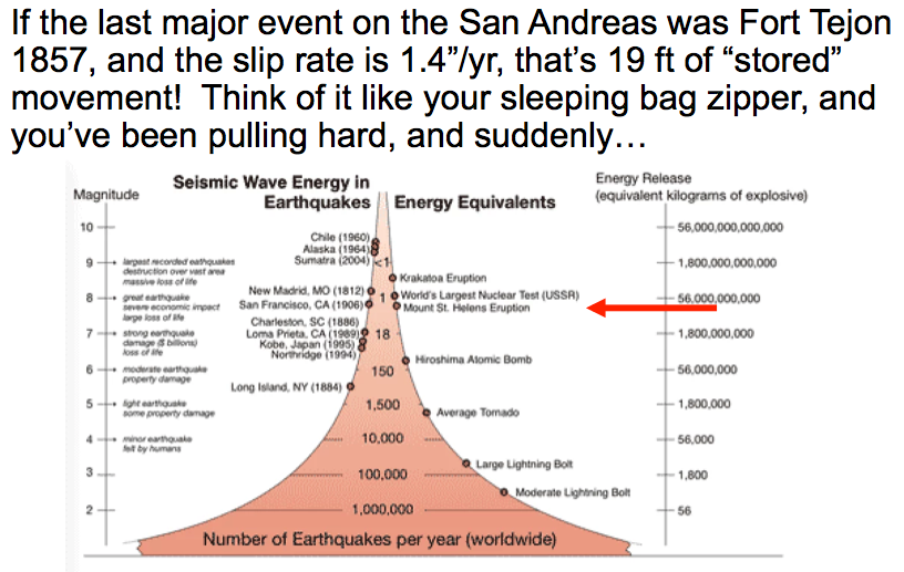
- Seismic Energy Equivalents.png (248.93 KiB) Viewed 686 times
What makes a Magnitude 8? Duration. What causes liquefaction? Duration. How long is the “shakeout” simulation? 2+ minutes.
3. Considerations
A. Campsites – keep in mind
i. What you’re under
ii. What you’re next to
iii. What you’re on
B. Exit routes
C. Communications
D. Supplies – take extra
4. General Preparedness
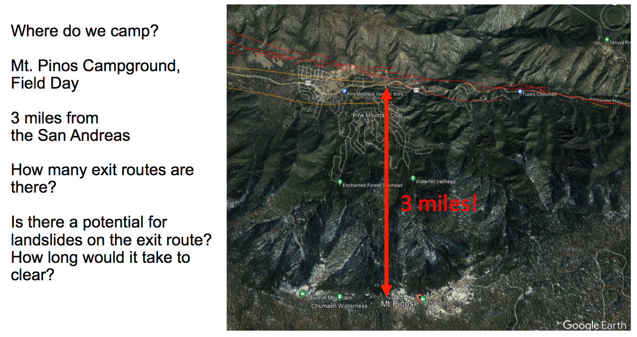
Where Mt. Pinos Campground is in relation to the San Andreas
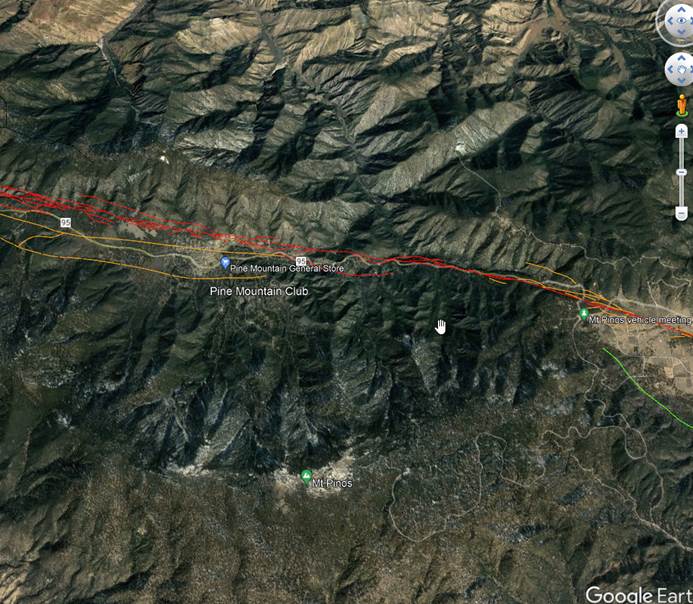
- E95CFF54-ECFD-40D3-A017-1165650096E3.jpeg (87.02 KiB) Viewed 722 times
Re: OAUSA Net - 8/4/22 - Outback Travel in Earthquake Land
Posted: Thu Aug 04, 2022 12:24 pm
by JackM-KK6WXQ
2. Risks
A. Regional
B. Local to where you’re going
C. Keep your eyes open (what to look for
i. USGS maps
ii. Landslides
iii. What is a seiche?
iv. What is liquefaction?
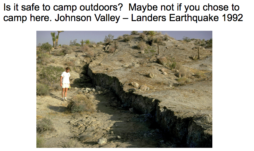
- Safe Outdoors.png (546.17 KiB) Viewed 686 times
Are there still faults that are unknown?
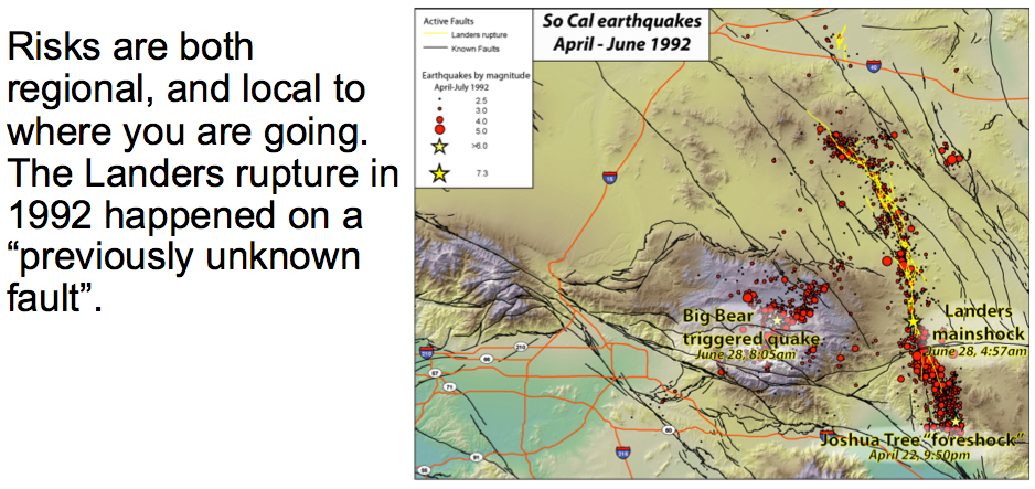
- Landers Rupture.png (570.95 KiB) Viewed 686 times

- Alquist-Priolo.png (11.39 KiB) Viewed 684 times
https://www.conservation.ca.gov/cgs/alquist-priolo
The Alquist-Priolo Act requires the State Geologist (CGS) to establish earthquake fault zones around the surface traces of active faults and to issue appropriate maps. CGS has identified earthquake fault zones in thirty-seven California counties, affecting more than one hundred cities. Here are a few ways for you to determine if a property is affected by an earthquake fault zone:
Put in your address, check local faulting and liquefaction
https://laist.com/news/climate-environm ... ival-guide
Adding faults to your Google Earth
https://www.usgs.gov/programs/earthquak ... mkml-files
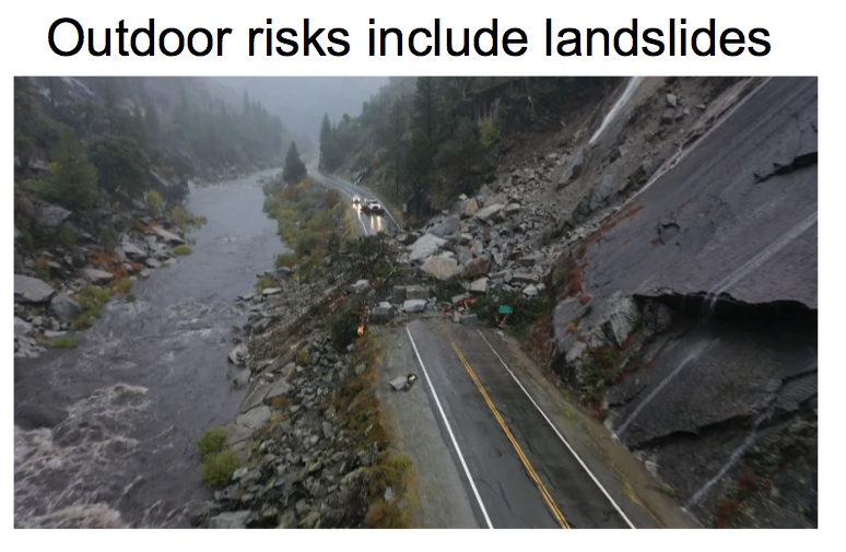
- Outdoor Risks Landslides.png (591.14 KiB) Viewed 683 times
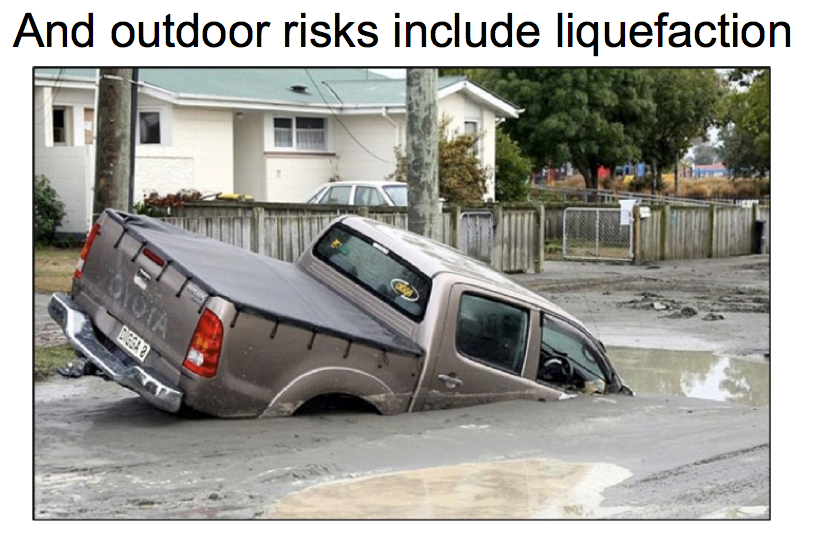
- Liquefaction.png (676.93 KiB) Viewed 682 times
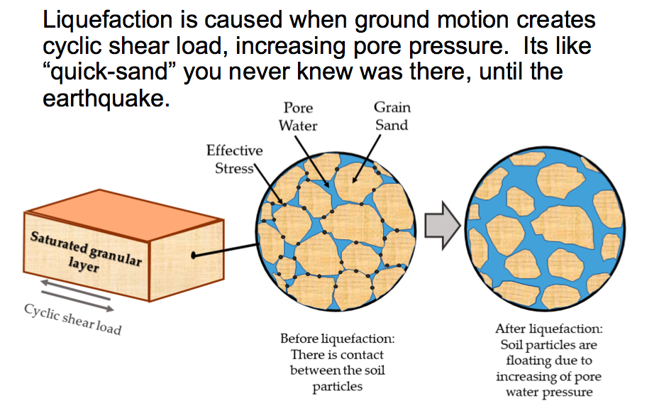
- Liquefaction Cause.png (330.58 KiB) Viewed 681 times
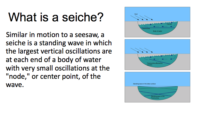
- Seiche.png (100.76 KiB) Viewed 680 times
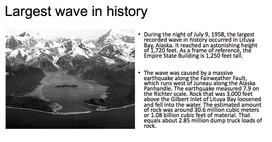
- Largest Wave.png (299.35 KiB) Viewed 679 times
Re: OAUSA Net - 8/4/22 - Outback Travel in Earthquake Land
Posted: Thu Aug 04, 2022 12:51 pm
by JackM-KK6WXQ
Considerations
A. Campsites - What you are under, what you are next to, and what you are on.
B. Exit Routes
C. Communications
D. Supplies
- Caruther's.png (1.15 MiB) Viewed 678 times
- Mt Pinos.png (1.26 MiB) Viewed 678 times
Re: OAUSA Net - 8/4/22 - Outback Travel in Earthquake Land
Posted: Thu Aug 04, 2022 1:45 pm
by KAP
Please check us in
Kevin KK6DGL
John KJ6UNC
Jack KK6WXQ
John KM6FXI
ANNOUNCEMENT-AUGUST 18 NET ON OUTDOOR APPs
Posted: Thu Aug 04, 2022 3:36 pm
by Jeff-OAUSA
Do you have a favorite outdoor oriented Application that you like to use? If so, consider volunteering to talk about your favorite outdoor oriented App during the August 18 OAUSA net.
The goal is to take a about 5 to 7 minutes to tell the group about your favorite outdoor App. It is as easy as keying up your Mic.
Outdoor Apps might cover any of the following topics: trip planning, trek tracking, ideal hunting/fishing times/dates, offroad route maps, ballistic calculators, star/planet identifiers, hike routes, bird identification, plant identification, animal identification, GPS locations, and more.
Apps running on Windows, IOS, Android, and other operating systems are candidates.
The 5-7 minute talk can cover: the App name, where to get the App, App cost, App operating system, main function of the App, examples of how you have used the App, pros of the App, cons of the App, etc.
About 1 week before the August 18 Net (likely August 12), I will start a Net Preview where you can post visuals to support the discussion of your App.
Please let me know if you are interested in talking about an App and which App it will be. I can be reached via email at
WD6USA@gmail.com.
Volunteers so far:
WD6USA; AllTrails App
Re: OAUSA Net - 8/4/22 - Outback Travel in Earthquake Land
Posted: Thu Aug 04, 2022 3:38 pm
by Jeff-OAUSA
Please check in WD6USA
Re: OAUSA Net - 8/4/22 - Outback Travel in Earthquake Land
Posted: Thu Aug 04, 2022 6:38 pm
by KA9WDX
Check in please - Thanks - Bernie
Re: OAUSA Net - 8/4/22 - Outback Travel in Earthquake Land
Posted: Thu Aug 04, 2022 6:39 pm
by H380
Please check me in WY6R -- Bob
Re: OAUSA Net - 8/4/22 - Outback Travel in Earthquake Land
Posted: Thu Aug 04, 2022 7:16 pm
by lrsrngr
KK6CTT for the online check-in! 08/04/22
A late entry, current information that ties in with the topic:
DEATH VALLEY NATIONAL PARK, Calif. (AP) — Record rainfall Friday triggered flash floods at Death Valley National Park that swept away cars, closed all roads and stranded hundreds of visitors and workers.
There were no immediate reports of injuries but roughly 60 vehicles were buried in mud and debris and about 500 visitors and 500 park workers were stuck inside the park, officials said.
The park near the California-Nevada state line received 1.46 inches (3.71 centimeters) of rain at the Furnace Creek area. That’s about 75% of what the area typically gets in a year and more than has ever been recorded for the entire month of August.
Since 1936, the only single day with more rain was April 15, 1988, when 1.47 inches (3.73 centimeters) fell, park officials said.
More information here:
https://www.newsbreak.com/news/26951662 ... share&s=i5