It's time to discuss some of the different products that are available for use who want to travel off the grid. I know this has been discussed in the past but in recent years there has been a proliferation of new products.
We will be looking at some old and new products here tonight. As we discuss the various devices I encourage anyone with experience on these devices to jump in with their comments and opinions. If there is something I didn't cover please jump-in and add your device and thought.
When looking at the various product options you need todo your do diligence. For instance can you import or export tracks, wave points, etc. Say your friend has a track you want to import into your unit, can you easily input the track or are their multiple steps. Is there a yearly subscription for software updates, etc.
Our first produce is the:
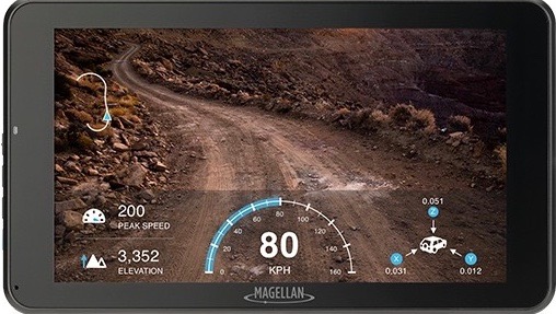
MAGELLAN TR7 CS PRO DUAL MOUNT TRAIL AND STREET GPS NAVIGATOR WITH A CAMERA HIGHLIGHT
Price: $629.99
Turn-by-Turn Trail and Street Navigation
Rotatable Built-in Camera with Sony’s Premium STARVIS Sensor
Optional Gauge Overlay or Time-Lapse Modes for Adventure Video
Pre-loaded with over 160,000 4WD, ATV, Motorcycle, and Snowmobile Trails in the USA
Hi-res (10M) 2D Topo and 3D Basemap of the USA and Canada with Free Updates
Track Recording and Community Publishing, Crowdsourced Track Database, and One-Touch Social Sharing
Free Map and Software Updates
Pros:
Buy and done. No annually subscription fees.
Multiple mounting options
Preloaded maps
Older product with proven track record
Cons:
Small 7" screen size
Display limited to device only
- tr7_cam_front_02_big_600x522_4-2.jpg (64.42 KiB) Viewed 7421 times
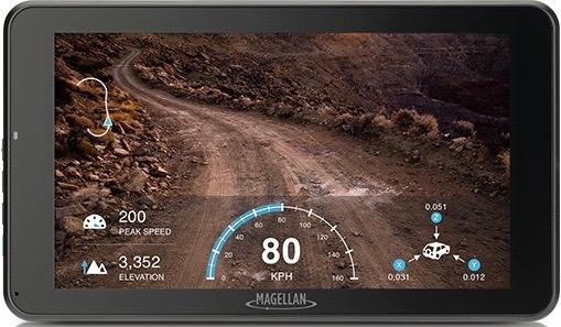
MAGELLAN TR7 CAM TRAIL AND STREET GPS NAVIGATOR WITH A CAMERA HIGHLIGHT
Price: $369.99
Turn-by-Turn Trail and Street Navigation
Rotatable Built-in Camera with Sony’s Premium STARVIS Sensor
Optional Gauge Overlay or Time-Lapse Modes for Adventure Video
Pre-loaded with over 160,000 4WD, ATV, Motorcycle, and Snowmobile Trails in the USA
Hi-res (10M) 2D Topo and 3D Basemap of the USA and Canada with Free Updates
Track Recording and Community Publishing, Crowdsourced Track Database, and One-Touch Social Sharing
Free Map and Software Updates
Pros:
Buy and done. No annually subscription fees
Preloaded maps
Older product with proven track record
Cons:
Small 7" screen size
Display limited to device only
Not H2O proof like above unit.
- tr7_cam_front_02_big_600x522_4-3.jpg (65.62 KiB) Viewed 7421 times
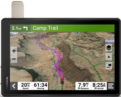
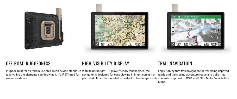
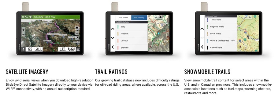
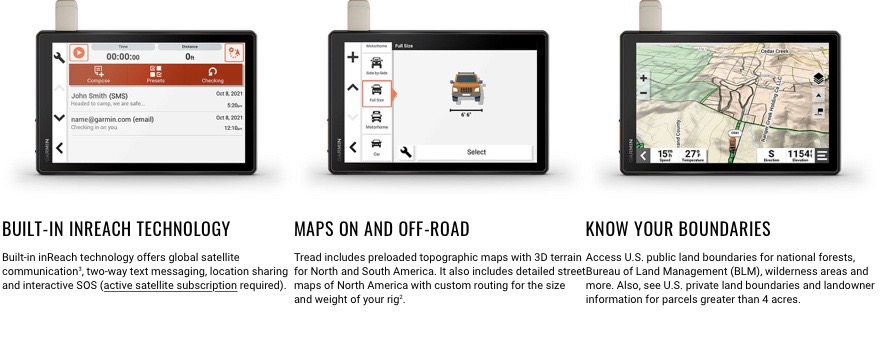
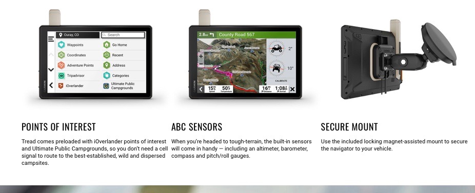
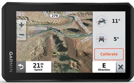
Garmin Tread® XL - Overland Edition
10” All-Terrain Navigator
Price: $1499.99
Navigate unpaved roads and trails by using turn-by-turn trail navigation1 with OpenStreetMap (OSM) and USFS Motor Vehicle Use Maps.
Custom routing for the size and weight of your rig2 and preloaded iOverlander™ points of interest (POIs) help you find where to set up camp.
This rugged navigator is IP67 weather-resistant and has an 10” ultrabright touchscreen display.
See vivid aerial views of terrain with downloadable, subscription-free BirdsEye Direct Satellite Imagery.
Use the Tread® app on your compatible smartphone to sync data across your various devices and plan routes.
Peace of mind comes built-in. With an active subscription, you can use inReach® technology for global satellite communication.
Pros:
One and one. Free updates
Large 10' Screen
Preloaded maps
inReach Built in (needs separate subscription. Standalone inReach mini cost is $399.99)
Established company.
Cons:
Display limited to device only
Price
- Overland Picture.jpg (41.37 KiB) Viewed 7421 times
- Overland pg 1.jpg (85.61 KiB) Viewed 7421 times
- Overland pg 2.jpg (85.25 KiB) Viewed 7421 times
- Overland pg 3.jpg (87.66 KiB) Viewed 7421 times
- Overland pg 4.jpg (72.03 KiB) Viewed 7421 times
Garmin Tread® - Base Edition
5.5” Powersport Navigator
Price: $599.99
Take your side-by-side off the beaten path with topographic mapping, private and public land info, forest service roads and trails.
The rugged Tread off-road GPS is IPX7 weather-resistant and features a glove-friendly 5.5” touchscreen display.
Use the Tread® app1 to sync data across your various devices.
Direct-to-device BirdsEye Direct Satellite Imagery can be downloaded to Tread without a computer.
Easily install on your powersport vehicle with the included powered mount and wiring harness with tube mount.
Pros:
One and one. Free updates
Preloaded maps
Established Company
Cons:
Designed more for Side-by-Side's but can be used for overloading.
Display limited to device only
Smaller 5.5" screen
- Powersport Picture.jpg (44.17 KiB) Viewed 7421 times