Not so long ago, I took a short stop-off at the Chuckawalla mountains to see the RED CLOUD.
I use to work an fly this area extensivly in the 1980's and 90's.
My dog was getting hyper so I told her to try her hand, "PAW", at driving.
Good thing she can't reach the peddles.
- I let my dog try her hand, PAW, at driving but she can't reach the peddles.
- Dog driving-RS.jpg (454.77 KiB) Viewed 5956 times
Much of the area to the east of the old Kieser Mine railroad tracks are now a reserve and there are BLM marker
signs set up near or along the boundarys.
- Example of more common new signs
- BLM sign-RS.jpg (352.9 KiB) Viewed 5959 times
Old cars and discarded cans and beds, stoves and spent ammo, are not uncommon.
- TRAFFIC...If I wait long enough it will rust out of my way.
- traffic-RS.jpg (521.19 KiB) Viewed 5956 times
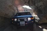
There are other mines and ruins throughout this area, some are only rock walls or rusty remains.
- RED CLOUD MINE RUINS
- Mine site-RS.jpg (545.33 KiB) Viewed 5955 times
Many of the holes are deep and unfenced; also the tunnels are caved in and unstable; KEEP OUT.
- Stay away from this stuff, "CYANIDE", as it can kill or make you very sick.
- DANGEROUS-RS.jpg (497.87 KiB) Viewed 5954 times
They were once used to process the mineral ores and then the waste was dumped into the wilderness...
yep, BAD STUFF.
- This stuff kills simply by touching it. It's called CYANIDE.
If you see drums, or old pink color sand...stay away. In the old days , people were not as careful with the environment. - old cynide spill-RS.jpg (1.14 MiB) Viewed 5955 times
These used to be beach sand before it was reheated and altered by geologic forces.
- Some of the WAY COOL Migmatite rocks and metamorphic out crops of geology in the canyon are worth the visit.
- metamorph sand-RS.jpg (527.63 KiB) Viewed 5948 times
- GREAT Ocotillos , should be blooming by late Feb. or March.
- Ocotillo cactus-rs.jpg (488.84 KiB) Viewed 5947 times
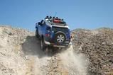
backcountry next to Chucawalla Peak. After the canyon becomes narrow, the HF is the only thing that might get out;
however, the ridge to the west is eventually accessable near the last mine ruins, and would be a fun place to do some quality
DXing on field day. You can drive almost to the top and the end of the canyon far south-east of the mine.
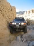
- WHAT PAINT ? hey it's a badge of courage... or NOT.
- Tight fit-RS.jpg (421.56 KiB) Viewed 5947 times

 _
_ _
_