Tonight our topic is 7.5 minute Topographic maps and related grids systems. These are the maps that relate very well to our outdoor recreational interests. We rely so heavily on electronic devises and electronic maps these days that we should review the basics of paper maps. You should take a paper map with you whether you buy an officially publication or print out a custom one.
The net went almost 2 hours and we had 27 check in's.
July 15, 2010 OAUSA NET - 7 ½ Minute Maps
-
toms

- OAUSA Board Member
- Posts: 951
- Joined: Wed Mar 12, 2008 11:50 am
- Call Sign: KI6FHA
- Location: Redondo Beach CA (5 miles south of LAX)
- Contact:
July 15, 2010 OAUSA NET - 7 ½ Minute Maps
See you on the Trail!
TomS
KI6FHA / WPZW486
Badlands Off-Road
tom@4x4training.com
http://www.4x4training.com
TomS
KI6FHA / WPZW486
Badlands Off-Road
tom@4x4training.com
http://www.4x4training.com

Re: July 15, 2010 OAUSA NET - 7 ½ Minute Maps
The Public Land Survey System (PLSS) is a way of subdividing and legally describing land in the United States. The PLSS is regulated by the U.S. Department of the Interior, Bureau of Land Management (BLM)
Originally proposed by Thomas Jefferson, the PLSS began shortly after the Revolutionary War, when the Federal government became responsible for large areas west of the thirteen original colonies. The government wished both to distribute land to Revolutionary War soldiers in reward for their service, as well as to sell land as a way of raising money for the nation. Before this could happen, the land needed to be surveyed.
The Land Ordinance of 1785 which provided for the systematic survey and monumentation of public domain lands, and the Northwest Ordinance of 1787 which established a rectangular survey system designed to facilitate the transfer of Federal lands to private citizens, were the beginning of the PLSS. Under Congressional mandate, cadastral surveys (surveys of the boundaries of land parcels) of public lands were undertaken to create parcels suitable for disposal by the Government. The extension of the rectangular system of surveys over the public domain has been in progress since 1785, and, where it applies, the PLSS forms the basis for most land transfers and ownership today. The Manual of Instructions for the Survey of the Public Lands Of The United States, 1973 documents current official procedures for PLSS surveys.
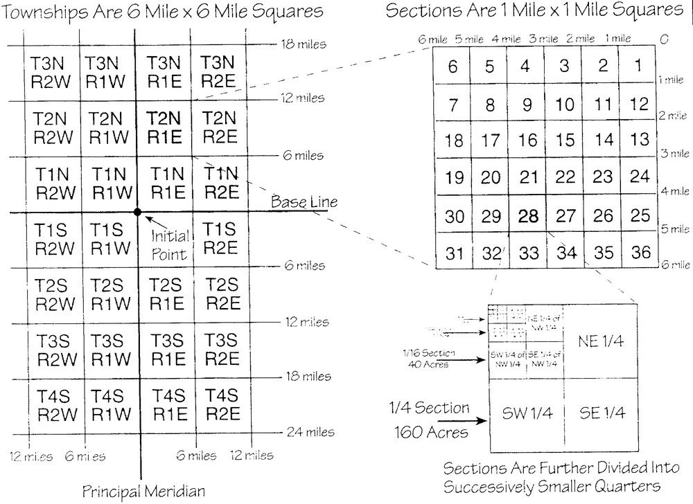
The surveying of any regional area is a multi-step process. First, two controlling survey lines are established for some relatively large area: a baseline, which runs east-west and a principal meridian, which runs north-south. These two lines pass through and intersect at a location known as an initial point. Subsequent work divides the land into survey townships of roughly 36 square miles or 6 miles on each side. This is done by the establishing of township and range lines which run parallel to the baseline and principal meridian, respectively, at six mile intervals. Lastly, townships are subdivided into 36 sections of one square mile (640 acres). Sections are numbered boustrophedonically within townships. Sections are further subdivided into quarter sections, quarter-quarter sections, etc; quarter sections are 160 acres. Quarter-quarter sections are 40 acres (the back 40)
If you look at the deed to any real property in California you will find the PLSS as the legal description of the location of the property.
There are 37 Principal Meridians, each is named, and these names are used to distinguish the various surveys. There are 3 Principal meridians in California: San Bernardino Meridian, Mt. Diablo Meridian & Humboldt Meridian.
In Southern California and in particular the San Bernardino National Forest, our initial point is located on the peak of Mt. San Bernardino. Baseline Street in San Bernardino follows the baseline and is named for it. If we look east along Baseline St. it will line up with the peak of Mt. San Bernardino.
From the initial point, the first township north is numbered 1N. The second is 2N etc. The first township south is numbered 1S. The second is 2S etc. From the initial point, the first range west is numbered 1W. The second is 2W etc. The first range east is numbered 1E. The second is 2E etc.
The USFS uses the PLSS to name roads and trails. Roads are named after the township in which they start. A road that starts in township 3 north would start with 3N. This designator is followed by a sequential number. 3N34 is the 34th trail numbered that starts in township 3 north. Trails less than 50” wide use the range designator in which they start. A trail that starts in range 1 west would start with 1W followed by a sequential number. 1W12 is the 12th trail that starts in range 1 west.
Both roads and trails have spurs and connector routes. Spurs (dead ends) add a letter after the road/trail number starting with A for the first road/trail numbered. 3N34D is the 4th spur road off 3N34 numbered. Connector routes add the letter X, Y or Z after the road/trail number. 3N34X connects on both ends to 3N34. While the system is not perfect, more often than not that above numbering/lettering system is pretty accurate.
USFS ground units use PLSS as their legal description for all incidents. ie: “Dispatch we have a report of black smoke in the SE ¼ of Section 7 T2N R3W”
Originally proposed by Thomas Jefferson, the PLSS began shortly after the Revolutionary War, when the Federal government became responsible for large areas west of the thirteen original colonies. The government wished both to distribute land to Revolutionary War soldiers in reward for their service, as well as to sell land as a way of raising money for the nation. Before this could happen, the land needed to be surveyed.
The Land Ordinance of 1785 which provided for the systematic survey and monumentation of public domain lands, and the Northwest Ordinance of 1787 which established a rectangular survey system designed to facilitate the transfer of Federal lands to private citizens, were the beginning of the PLSS. Under Congressional mandate, cadastral surveys (surveys of the boundaries of land parcels) of public lands were undertaken to create parcels suitable for disposal by the Government. The extension of the rectangular system of surveys over the public domain has been in progress since 1785, and, where it applies, the PLSS forms the basis for most land transfers and ownership today. The Manual of Instructions for the Survey of the Public Lands Of The United States, 1973 documents current official procedures for PLSS surveys.
The surveying of any regional area is a multi-step process. First, two controlling survey lines are established for some relatively large area: a baseline, which runs east-west and a principal meridian, which runs north-south. These two lines pass through and intersect at a location known as an initial point. Subsequent work divides the land into survey townships of roughly 36 square miles or 6 miles on each side. This is done by the establishing of township and range lines which run parallel to the baseline and principal meridian, respectively, at six mile intervals. Lastly, townships are subdivided into 36 sections of one square mile (640 acres). Sections are numbered boustrophedonically within townships. Sections are further subdivided into quarter sections, quarter-quarter sections, etc; quarter sections are 160 acres. Quarter-quarter sections are 40 acres (the back 40)
If you look at the deed to any real property in California you will find the PLSS as the legal description of the location of the property.
There are 37 Principal Meridians, each is named, and these names are used to distinguish the various surveys. There are 3 Principal meridians in California: San Bernardino Meridian, Mt. Diablo Meridian & Humboldt Meridian.
In Southern California and in particular the San Bernardino National Forest, our initial point is located on the peak of Mt. San Bernardino. Baseline Street in San Bernardino follows the baseline and is named for it. If we look east along Baseline St. it will line up with the peak of Mt. San Bernardino.
From the initial point, the first township north is numbered 1N. The second is 2N etc. The first township south is numbered 1S. The second is 2S etc. From the initial point, the first range west is numbered 1W. The second is 2W etc. The first range east is numbered 1E. The second is 2E etc.
The USFS uses the PLSS to name roads and trails. Roads are named after the township in which they start. A road that starts in township 3 north would start with 3N. This designator is followed by a sequential number. 3N34 is the 34th trail numbered that starts in township 3 north. Trails less than 50” wide use the range designator in which they start. A trail that starts in range 1 west would start with 1W followed by a sequential number. 1W12 is the 12th trail that starts in range 1 west.
Both roads and trails have spurs and connector routes. Spurs (dead ends) add a letter after the road/trail number starting with A for the first road/trail numbered. 3N34D is the 4th spur road off 3N34 numbered. Connector routes add the letter X, Y or Z after the road/trail number. 3N34X connects on both ends to 3N34. While the system is not perfect, more often than not that above numbering/lettering system is pretty accurate.
USFS ground units use PLSS as their legal description for all incidents. ie: “Dispatch we have a report of black smoke in the SE ¼ of Section 7 T2N R3W”
Doug N1DUG
2004 WJ
1996 ZJ locked on 33's, Claytons LAs
1999 Ford F250 V10 4x4 19.5s, 1988 Lance ES3000
Life Member CA4WD, CORVA, BRC
over 2000 hours volunteered with the SBNFA
CASSP
TreadLightly! Trainer
ForestAid Reforestation Supervisor
2004 WJ
1996 ZJ locked on 33's, Claytons LAs
1999 Ford F250 V10 4x4 19.5s, 1988 Lance ES3000
Life Member CA4WD, CORVA, BRC
over 2000 hours volunteered with the SBNFA
CASSP
TreadLightly! Trainer
ForestAid Reforestation Supervisor
Who is online
Users browsing this forum: No registered users and 1 guest