A few months ago we received requests to do another net on wilderness navigation. We've done this net before and the response has always been huge. So, the net this week will cover this topic. In the past, it was impossible to cover all of the areas that wilderness navigation deserves, so we will hold out the possibility of a second net, if necessary.
The continually evolving field of electronic navigation is nothing short of amazing. While navigating in the wilderness has changed significantly, there is one thing that has not changed - the need for paper maps. Although paper maps are not as prevalent as in the past, they are an indispensable back-up to your electronic tools, and they can serve as a valuable supplement to the new digital age methods of navigation. Off road, there are some absolutes that the wise and prepared traveler needs to acknowledge. Among these absolutes, especially when it comes to the new-fangled electronic tools we use for navigation, is the recognition that ALL mechanical and electronic devices will break, sooner or later. The other absolute is that you will never know when. This is why paper maps should always accompany you in the outback, especially when you are new to the area.
Our net this week will focus mainly on the use of a computer and a GPS. Computers come in may forms these days and include laptops, notebooks, mini laptops, tablets, carputers, etc. GPS devices also come in may forms and include hand held or dash mounted units, integrally mounted units in computers, and small external devices that can be attached to a computer or radio. The field of navigation equipment, including software and hardware, is in a great state of transition. Some of the biggest players have left the market and created a vacuum which has been filled, in part, by many other innovative products. Mapping information is also going through great transitions as well.
In addition to aiding you in wilderness navigation, your set-up should also allow you to do the trip planning necessary to select the best routes to travel, where to camp, what to see and in what order, etc. With a proper approach, your travel plans and mapping information should be shared with the other members of your group, even if they have a system that is different from yours.
We know what works best for us, but we also know that there are many other approaches that should be included in the discussion. Don't be shy - add your comments to this thread and join us for the net.
Pictures, information and links to follow.
OAUSA Net - April 21, 2016 - Wilderness Navigation
-
DaveK

- Site Admin
- Posts: 3849
- Joined: Tue Mar 11, 2008 10:33 am
- Call Sign: K6DTK
- Location: American Southwest
OAUSA Net - April 21, 2016 - Wilderness Navigation
DaveK
K6DTK
Extremism in the defense of liberty is no vice.
Moderation in the pursuit of justice is no virtue.
K6DTK
Extremism in the defense of liberty is no vice.
Moderation in the pursuit of justice is no virtue.
-
DaveK
- Site Admin
- Posts: 3849
- Joined: Tue Mar 11, 2008 10:33 am
- Call Sign: K6DTK
- Location: American Southwest
Re: OAUSA Net - April 21, 2016 - Wilderness Navigation
Mapping programs are available from a number of companies, and the choices of features is impressive. While many of these programs are meant for standard computer use (desktops, tablets, and laptops) there is a growing trend toward apps for smart phones that will assist in wilderness navigation. Below are some well known navigation programs that work with computers and a GPS device and some that will work with cell phones:
Links
1. DeLorme Navigation Software - Topo North America - http://shop.delorme.com/OA_HTML/DELibeC ... tion=10742
2. Overland Navigator - http://overlandnavigator.com/
3. National Geographic TOPO! - (from Amazon) http://www.amazon.com/National-Geograph ... california
4. Terrain Navigator (for smart phone use)- https://www.terrainnavigator.com/
5. Ozi Explorer - http://www.oziexplorer.com/
6. Rugged Routes (more race and high speed racing oriented) http://ruggedroutes.com/
Certain programs allow you to download your own maps (including satellite imagery) and some come already equipped with the maps built into the software. Do your research and seek the input of people who are using the various programs that you are considering. Make sure that you have firmly settled on your needs before you make a purchase.
DaveK
K6DTK
Extremism in the defense of liberty is no vice.
Moderation in the pursuit of justice is no virtue.
K6DTK
Extremism in the defense of liberty is no vice.
Moderation in the pursuit of justice is no virtue.
-
DaveK
- Site Admin
- Posts: 3849
- Joined: Tue Mar 11, 2008 10:33 am
- Call Sign: K6DTK
- Location: American Southwest
Re: OAUSA Net - April 21, 2016 - Wilderness Navigation
In this writers opinion, screen size (of the device that is displaying your map) is an important consideration when deciding which type of device you want to use. Since we are focused on vehicle navigation, in the wilderness, screen size becomes even more important. Off road travel means that you WILL encounter pot holes, rocks, uneven surfaces, washed out roads, washboards, more rocks, and sometimes worse. Obviously, concentration on driving is paramount, but when you are involved in making sure that you are following the right trail, the small screen of a phone males your job that much more difficult. When vehicle space permits and finances allow, there is no substitute for the larger screen of a laptop.
When you combine the computing power of a laptop with the larger screen, it can offer an unbeatable navigation system. While some computers come equipped with built in GPS units, there are some advantages to using an external GPS (connected to the computer). The most obvious benefit is that you have a second device to rely upon if the computer goes down. The second is that it can serve as a hand held GPS for hiking. Below are examples of a computer navigation program using USGS Topo Maps and a GPS using Garmin proprietary mapping. Note the similarity between the maps. An additional benefit of two separate units ( a computer and a GPS) is that each can be programmed with your destinations.
Computer navigation map
This is an example of a mapping program that uses USGS maps. The area displayed is the Anza Borrego Desert, in the area of the Collins Valley;
This is an external GPS (connected to and independant of the computer) also displaying the same area of the Anza Borrego Desert.
When you combine the computing power of a laptop with the larger screen, it can offer an unbeatable navigation system. While some computers come equipped with built in GPS units, there are some advantages to using an external GPS (connected to the computer). The most obvious benefit is that you have a second device to rely upon if the computer goes down. The second is that it can serve as a hand held GPS for hiking. Below are examples of a computer navigation program using USGS Topo Maps and a GPS using Garmin proprietary mapping. Note the similarity between the maps. An additional benefit of two separate units ( a computer and a GPS) is that each can be programmed with your destinations.
Computer navigation map
This is an example of a mapping program that uses USGS maps. The area displayed is the Anza Borrego Desert, in the area of the Collins Valley;
- Computer Screen of Navigation.JPG (79.71 KiB) Viewed 886 times
- GPS Screen.JPG (84.7 KiB) Viewed 886 times
DaveK
K6DTK
Extremism in the defense of liberty is no vice.
Moderation in the pursuit of justice is no virtue.
K6DTK
Extremism in the defense of liberty is no vice.
Moderation in the pursuit of justice is no virtue.
-
toms

- OAUSA Board Member
- Posts: 951
- Joined: Wed Mar 12, 2008 11:50 am
- Call Sign: KI6FHA
- Location: Redondo Beach CA (5 miles south of LAX)
- Contact:
Re: OAUSA Net - April 21, 2016 - Wilderness Navigation
Product Spotlight -Jack Covers
Have you ever broken a tire bead while 4- wheeling and found that the hi-lift jack was barely operational due to dust, dirt and mud packed into the operating mechanism? Not only is it frustrating but dangerous as well. Since most of us bolt our hi-lift on the outside of the vehicle, it is not uncommon to find the mechanism less than functional.
A simple boot over the working parts of the jack to protect it and keep it clean is an idea that has been around for a while. The current offerings have not been very successful. At TDS this week, I discovered a new product for the hi-lift jack cover that looks promising.
Adam Woods has built a better “mouse trap” which he market under the name http://www.jackcovers.com The new cover marries a neoprene inner liner with a marine grade vinyl shell on the outside. It has a heavy duty - #10 Marine grade zipper, treated for mildew and antimicrobial, and available in 20 + colors. Since the product covers a number of holes on the jack upright, Adam explained to me he analyzed which holes most of us use to mount a hi-lift and offers two sizes of the cover - 11" and 15”- to allow several mounting combinations.
Of course if the workings of the Jack get too bad you can order a repair kit from Hi-Lift for about $20.
The single bolt in the package is the shear pin. It breaks at about 7000 pounds. Get a new one do not replace it with a standard bolt!
- HILift001m.jpg (183.93 KiB) Viewed 883 times
A simple boot over the working parts of the jack to protect it and keep it clean is an idea that has been around for a while. The current offerings have not been very successful. At TDS this week, I discovered a new product for the hi-lift jack cover that looks promising.
Adam Woods has built a better “mouse trap” which he market under the name http://www.jackcovers.com The new cover marries a neoprene inner liner with a marine grade vinyl shell on the outside. It has a heavy duty - #10 Marine grade zipper, treated for mildew and antimicrobial, and available in 20 + colors. Since the product covers a number of holes on the jack upright, Adam explained to me he analyzed which holes most of us use to mount a hi-lift and offers two sizes of the cover - 11" and 15”- to allow several mounting combinations.
Of course if the workings of the Jack get too bad you can order a repair kit from Hi-Lift for about $20.
The single bolt in the package is the shear pin. It breaks at about 7000 pounds. Get a new one do not replace it with a standard bolt!
- HILift002m.jpg (144.34 KiB) Viewed 861 times
See you on the Trail!
TomS
KI6FHA / WPZW486
Badlands Off-Road
tom@4x4training.com
http://www.4x4training.com
TomS
KI6FHA / WPZW486
Badlands Off-Road
tom@4x4training.com
http://www.4x4training.com

Re: OAUSA Net - April 21, 2016 - Wilderness Navigation
KK6CTT...set me up for an online check-in please!
Always great to see techniques in navigation. I'm a fan of the DeLorme Atlas and Gazetteer products to coincide with my GPS and other map sources.
https://shop.delorme.com/OA_HTML/DELibe ... tion=10096
Another point of use is to always orient your map with the terrain and get away from holding your map with the top of the page always in the up position. Rotate your map so that the way you see the road/trail/terrain coincides with the way your map is oriented. This simple technique makes a huge difference for even the more advanced map reader.
H-U-A or "Hooah!" = Heard Understood & Acknowledged. In context: "Roger that sir, HUA!"
-
DaveK
- Site Admin
- Posts: 3849
- Joined: Tue Mar 11, 2008 10:33 am
- Call Sign: K6DTK
- Location: American Southwest
Re: OAUSA Net - April 21, 2016 - Wilderness Navigation
With a computer and GPS working together, here is what your screen will show as you travel. Note the blue lines - they represent our tracks. If you look closely, you will notice that there are yellow lines underneath the blue ones. The yellow lines were hand drawn trails which were created as part of our trip planning. The remaining yellow lines represent possible side trips that were not taken.
Also note the map detail of this USGS Topo map. In the top left hand corner and in the center, you can see notes that I placed on the map.
Also note the map detail of this USGS Topo map. In the top left hand corner and in the center, you can see notes that I placed on the map.
- Topo Map w trails and Info.JPG (280 KiB) Viewed 856 times
DaveK
K6DTK
Extremism in the defense of liberty is no vice.
Moderation in the pursuit of justice is no virtue.
K6DTK
Extremism in the defense of liberty is no vice.
Moderation in the pursuit of justice is no virtue.
-
DaveK
- Site Admin
- Posts: 3849
- Joined: Tue Mar 11, 2008 10:33 am
- Call Sign: K6DTK
- Location: American Southwest
Re: OAUSA Net - April 21, 2016 - Wilderness Navigation
One of the most annoying (and sometimes dangerous) things that WILL happen when you are on the trail is the movement of the contents of your vehicle. Unless your heavy objects (like refrigerators, ice chests, etc) are securely mounted they, at best, will rattle and collide with each other (translated: damage each other). At worst, they can become lethal projectiles in the event of an accident.
The need to securely mount things includes your navigation equipment. Aside from the risks and dangers of wobbling or loose equipment, it is difficult or impossible to read your computer or GPS screen when it is moving all over the place. I finally resolved to cure this problem, and soon discovered that there were a lot of companies that made vehicle laptop mounts, but almost all of them were intended for paved roads. It became apparent, very early on, that these computer and GPS mounts, and especially ones which relied on a flexible arm, were not adequate.
So, a few years ago, in my quest for a high quality, rugged mount, I finally discovered one company that made a mount which was the closest to my needs and which was a high quality unit - Jotto Desk. With some modifications, I created a mount which is solid, rugged, stable and out of the way (mostly):
About a month ago, Jotto released a new version of their vehicle laptop mount which is described as follows (http://jottopublicsafety.gojotto.com/ne ... o-Desk.htm) :
The need to securely mount things includes your navigation equipment. Aside from the risks and dangers of wobbling or loose equipment, it is difficult or impossible to read your computer or GPS screen when it is moving all over the place. I finally resolved to cure this problem, and soon discovered that there were a lot of companies that made vehicle laptop mounts, but almost all of them were intended for paved roads. It became apparent, very early on, that these computer and GPS mounts, and especially ones which relied on a flexible arm, were not adequate.
So, a few years ago, in my quest for a high quality, rugged mount, I finally discovered one company that made a mount which was the closest to my needs and which was a high quality unit - Jotto Desk. With some modifications, I created a mount which is solid, rugged, stable and out of the way (mostly):
- DTK Laptop Mount (Large).JPG (90.21 KiB) Viewed 850 times
I spoke to the Jotto Desk people today and got a description of the new HD mount. It is impressive - all metal, no plastic!!! Here is what it looks like (also from the Jotto website)Jotto Desk® is excited to introduce the NEW Heavy Duty (HD) line of computer laptop mounts. These HD Mounts offer the next level in ruggedness and durability…making this the premium solution for securing a laptop in a law enforcement or fleet vehicle. They feature a heavy duty vehicle specific mounting base, rugged pole/stand for height adjustment, swing arm for horizontal adjustment, a tilt/swivel plate and are capped off with our new A-MOD Desktop.
- Jotto HD Laptop Mount.jpg (62.57 KiB) Viewed 850 times
DaveK
K6DTK
Extremism in the defense of liberty is no vice.
Moderation in the pursuit of justice is no virtue.
K6DTK
Extremism in the defense of liberty is no vice.
Moderation in the pursuit of justice is no virtue.

Re: OAUSA Net - April 21, 2016 - Wilderness Navigation
Online check in.
Thanks,
Roger
Thanks,
Roger
Roger WZ6B
2014 JKUR
2014 JKUR

Re: OAUSA Net - April 21, 2016 - Wilderness Navigation
Dave
Please check me in. I will listening.
Kevin
KK6DGL
Please check me in. I will listening.
Kevin
KK6DGL
“A human being should be able to change a diaper, plan an invasion, butcher a hog, conn a ship, design a building, write a sonnet, balance accounts, build a wall, set a bone, comfort the dying, take orders, give orders, cooperate, act alone, solve equations, analyze a new problem, pitch manure, program a computer, cook a tasty meal, fight efficiently, die gallantly. Specialization is for insects”.
Robert A. Heinlein
Robert A. Heinlein

Re: OAUSA Net - April 21, 2016 - Wilderness Navigation
I've been trying out various in vehicle PCs for the last 10 years. Most have been based on a series of small form factor EPIA mother boards. EPIA stands for Embedded Platform Innovative Architecture which was defined by VIA. These generally have the CPU soldered directly to the motherboard and are mostly aimed at the embedded computer market. They do make nice small, quiet, low power PCs for general home use and for home theaters.
Several companies started offering cases and power supplies for these motherboards designed for car PCs. This seemed like a good approach for off road navigation since you're not tied to a particular mapping program or vendor's maps. The PC can also be used for another other common PC use such as storing music, backing up your photos you take on the road, storing PDF copies of your manuals, etc.
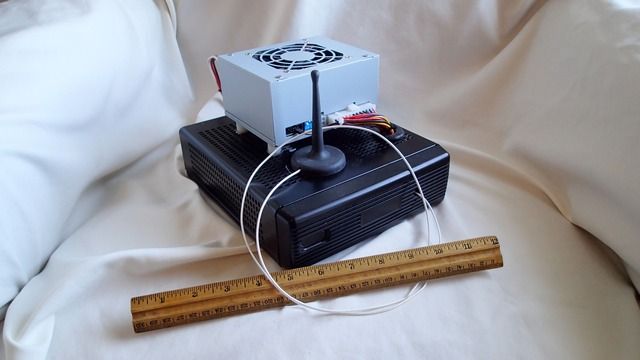
My latest EPIA vehicle computer based a Zotac motherboard with a dual core Intel Atom processor and Nvidia ION architecture. The silver box on top is a 6 to 36 volt input power supply from mini-box.com
I've had mixed success with this approach. Some motherboards were not completely compatible with the 12 or 24 volt DC power supplies. Often the power on function would not work correctly. The power supplies have 3 wires, positive that is always hot, a positive wire connected to a source which is hot when the car is on, and a negative ground. The power supply connects to the mother board power switch terminal and is supposed to turn on the mother board after a selected delay when power is detected on the switched line. Conversely, the computer is powered off after a selected delay when power is removed from the switched line. Unfortunately, more often than not the on/off signals generated by the power supply were not compatible with the mother boards making it necessary to have a power button in reach and having to remember to power the computer on and off.
Most of the computer mapping software runs on Windows so that introduced another set of headaches. The system would have to be rebuilt with every major update to Windows. It seemed like I was spending more time rebuilding the systems and tweaking the software than actually using them on the road.
I was starting to look for tablet based navigation solutions when I saw that Intel had introduced a new line of very small PC in the NUC or Next Unit of Computing format. I decided to give a vehicle PC another try.
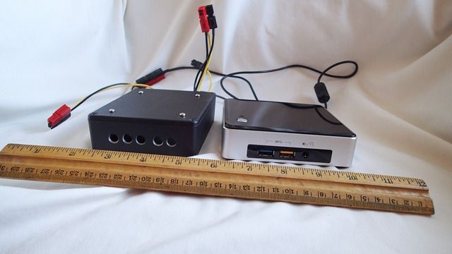
Intel NUC5i5RYK on the right with a mini-box DC-DC NUC power supply in a small aluminum box on the left. The power supply is the same form factor as a 2.5" laptop disk drive although it is slightly thicker. It could be housed in a much smaller box. Prices of solid state disks or SSDs have dropped significantly in the last couple of years. The compact size of this particular NUC computer is made possible by using the new M.2 format SSD which is very small and thin.
Information on Intel NUC computers - http://www.intel.com/content/www/us/en/ ... rview.html
Mini-box.com - http://www.mini-box.com/site/index.html
As you can see, the NUC and power supply is smaller than the power supply alone for the EPIA based computer making it much easier to find a place to mount it in your vehicle. It would be even more compact if the power supply was integrated into the computer case. The NUC line of computers is designed so that that vendors can offer different "lids" for the computer case to hold add on hardware. Intel publishes the CAD files on their website so you can make your own lids if you have access to a 3D printer. Mini-box doesn't currently have a lid that will hold the power supply but they are planning to offer one in the future.
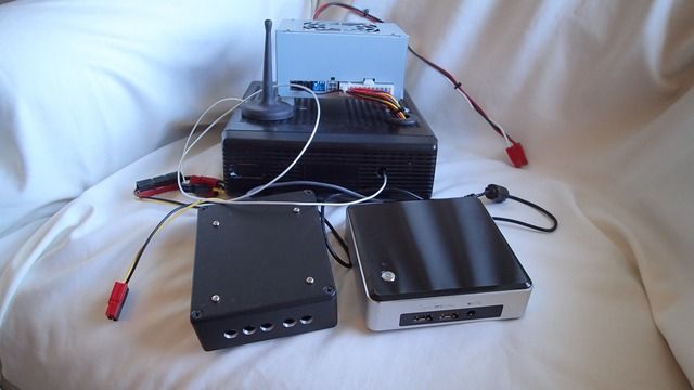
Here are the EPIA and NUC computers together for a comparison.
I've been very happy with this current set up. The power supply switches the NUC on and off using a USB signal. It worked perfectly the first time I hooked it up. To avoid the Windows upgrade problem I plan to keep this system on Windows 8.1 and not to connect it to the Internet unless its absolutely necessary.
For a monitors I use Xenarc 700 series touch screen monitors. I have a dedicated monitor for each vehicle and my current plan is to swap the NUC between the Tacoma and the Pinzgauer as needed.
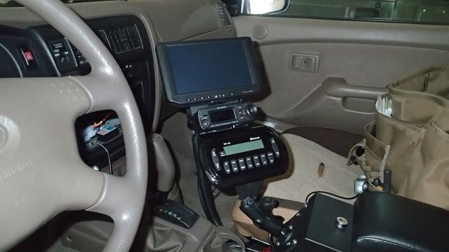
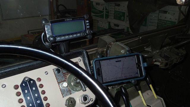
Here is a picture of the monitor in the Tacoma with the Yausu FTM-10 head unit mounted on a RAM mount. The AM/FM radio head unit is mounted on another RAM mount on the center console.
For software on the PC I've been using Overland Navigator, Delorme TOPO USA, and National Geographic TOPO for California. For the GPS input I use a Garmin GPS-18x USB puck style receiver. The GPS-18 has a strong magnet which I put on the roof of the Tacoma or anywhere in the cab of the Pinzgauer. It's plenty sensitive enough so that the cloth top does not interfere with the GPS signal reception.
To allow multiple programs to share the GPS data I use a program called Franson GPS Gate (http://gpsgate.com/products/gpsgate_client). In addition to creating multiple virtual GPS ports it also converts the proprietary Garmin GPS data format to the more standard NEMA format for programs that require it.
Since I had already started looking into tablet based navigation solutions and I upgraded to an iPhone 6 Plus I decided to add mounts in the Tacoma and Pinzgauer for the iPhone.
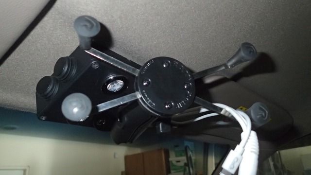
With the FlipPac camper on the Tacoma I can't see out the rear window so I replaced with factory rear view mirror and interior light with a small box that includes red and white interior lights, selector switches, and a RAM mount for the iPhone. The lightening and audio cables run through the headliner to the back of the cab. This puts the iPhone in a convenient and not too distracting location.
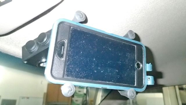
Tacoma RAM mount with the iPhone
I used a similar setup in the Pinzgauer with an additional RAM mount for the Kenwood TDM-700 head unit.
I find it very handy to have both the PC and iPhone for map displays. I can run different map programs with different qualities or have wide area and close in displays of the same map.
For navigation software I have street oriented applications like Apple Maps and Google Maps. My favorite off road application is Gaia. That program has access to the same USGS maps used by Overland Navigator. Gaia will download the maps as needed if you have a cell phone connection or you can download the map "tiles" for areas you visit so you don't need a cellular connection in the back country.
I also use MotionX-GPS and MotionX-GPS Drive. In addition to these I use the Earthmate application which connects to the inReach satellite communicator. This application will also enable GPS mapping on iOS devices without a built-in GPS.
The biggest drawback I've found with the iOS mapping applications is that you need to remember to download the maps for the areas you plan to visit before your trip if you want to have continuous map coverage when you don't have a cell signal.
With the wide variety of iOS navigation apps I could easily give up on the PC and get by with just the iPhone. The PC has the advantage of having the maps pre-loaded and has the capability of running many other Windows apps.
I always carry paper maps as a backup to the technology based maps as well.
Several companies started offering cases and power supplies for these motherboards designed for car PCs. This seemed like a good approach for off road navigation since you're not tied to a particular mapping program or vendor's maps. The PC can also be used for another other common PC use such as storing music, backing up your photos you take on the road, storing PDF copies of your manuals, etc.
My latest EPIA vehicle computer based a Zotac motherboard with a dual core Intel Atom processor and Nvidia ION architecture. The silver box on top is a 6 to 36 volt input power supply from mini-box.com
I've had mixed success with this approach. Some motherboards were not completely compatible with the 12 or 24 volt DC power supplies. Often the power on function would not work correctly. The power supplies have 3 wires, positive that is always hot, a positive wire connected to a source which is hot when the car is on, and a negative ground. The power supply connects to the mother board power switch terminal and is supposed to turn on the mother board after a selected delay when power is detected on the switched line. Conversely, the computer is powered off after a selected delay when power is removed from the switched line. Unfortunately, more often than not the on/off signals generated by the power supply were not compatible with the mother boards making it necessary to have a power button in reach and having to remember to power the computer on and off.
Most of the computer mapping software runs on Windows so that introduced another set of headaches. The system would have to be rebuilt with every major update to Windows. It seemed like I was spending more time rebuilding the systems and tweaking the software than actually using them on the road.
I was starting to look for tablet based navigation solutions when I saw that Intel had introduced a new line of very small PC in the NUC or Next Unit of Computing format. I decided to give a vehicle PC another try.
Intel NUC5i5RYK on the right with a mini-box DC-DC NUC power supply in a small aluminum box on the left. The power supply is the same form factor as a 2.5" laptop disk drive although it is slightly thicker. It could be housed in a much smaller box. Prices of solid state disks or SSDs have dropped significantly in the last couple of years. The compact size of this particular NUC computer is made possible by using the new M.2 format SSD which is very small and thin.
Information on Intel NUC computers - http://www.intel.com/content/www/us/en/ ... rview.html
Mini-box.com - http://www.mini-box.com/site/index.html
As you can see, the NUC and power supply is smaller than the power supply alone for the EPIA based computer making it much easier to find a place to mount it in your vehicle. It would be even more compact if the power supply was integrated into the computer case. The NUC line of computers is designed so that that vendors can offer different "lids" for the computer case to hold add on hardware. Intel publishes the CAD files on their website so you can make your own lids if you have access to a 3D printer. Mini-box doesn't currently have a lid that will hold the power supply but they are planning to offer one in the future.
Here are the EPIA and NUC computers together for a comparison.
I've been very happy with this current set up. The power supply switches the NUC on and off using a USB signal. It worked perfectly the first time I hooked it up. To avoid the Windows upgrade problem I plan to keep this system on Windows 8.1 and not to connect it to the Internet unless its absolutely necessary.
For a monitors I use Xenarc 700 series touch screen monitors. I have a dedicated monitor for each vehicle and my current plan is to swap the NUC between the Tacoma and the Pinzgauer as needed.
Here is a picture of the monitor in the Tacoma with the Yausu FTM-10 head unit mounted on a RAM mount. The AM/FM radio head unit is mounted on another RAM mount on the center console.
For software on the PC I've been using Overland Navigator, Delorme TOPO USA, and National Geographic TOPO for California. For the GPS input I use a Garmin GPS-18x USB puck style receiver. The GPS-18 has a strong magnet which I put on the roof of the Tacoma or anywhere in the cab of the Pinzgauer. It's plenty sensitive enough so that the cloth top does not interfere with the GPS signal reception.
To allow multiple programs to share the GPS data I use a program called Franson GPS Gate (http://gpsgate.com/products/gpsgate_client). In addition to creating multiple virtual GPS ports it also converts the proprietary Garmin GPS data format to the more standard NEMA format for programs that require it.
Since I had already started looking into tablet based navigation solutions and I upgraded to an iPhone 6 Plus I decided to add mounts in the Tacoma and Pinzgauer for the iPhone.
With the FlipPac camper on the Tacoma I can't see out the rear window so I replaced with factory rear view mirror and interior light with a small box that includes red and white interior lights, selector switches, and a RAM mount for the iPhone. The lightening and audio cables run through the headliner to the back of the cab. This puts the iPhone in a convenient and not too distracting location.
Tacoma RAM mount with the iPhone
I used a similar setup in the Pinzgauer with an additional RAM mount for the Kenwood TDM-700 head unit.
I find it very handy to have both the PC and iPhone for map displays. I can run different map programs with different qualities or have wide area and close in displays of the same map.
For navigation software I have street oriented applications like Apple Maps and Google Maps. My favorite off road application is Gaia. That program has access to the same USGS maps used by Overland Navigator. Gaia will download the maps as needed if you have a cell phone connection or you can download the map "tiles" for areas you visit so you don't need a cellular connection in the back country.
I also use MotionX-GPS and MotionX-GPS Drive. In addition to these I use the Earthmate application which connects to the inReach satellite communicator. This application will also enable GPS mapping on iOS devices without a built-in GPS.
The biggest drawback I've found with the iOS mapping applications is that you need to remember to download the maps for the areas you plan to visit before your trip if you want to have continuous map coverage when you don't have a cell signal.
With the wide variety of iOS navigation apps I could easily give up on the PC and get by with just the iPhone. The PC has the advantage of having the maps pre-loaded and has the capability of running many other Windows apps.
I always carry paper maps as a backup to the technology based maps as well.
Last edited by NotAMog on Thu Apr 21, 2016 8:25 pm, edited 4 times in total.
Bruce Berger
KD6GCO
'72 Pinzgauer 710M 2.6i
'91 Honda ST1100 199,000miles and counting (I hope to make it to at least half the places this bike has been)
'04 Tacoma (soon to be for sale)
'07 Moto Guzzi Norge - Corsa Red - The faster color
'21 UBCO 2x2 Electric Adventure Bike
'22 Energica Eva Ribelle Electric Motorcycle
'23 Jeep Gladiator Rubicon with Skinny Guy Camper
KD6GCO
'72 Pinzgauer 710M 2.6i
'91 Honda ST1100 199,000miles and counting
'04 Tacoma (soon to be for sale)
'07 Moto Guzzi Norge - Corsa Red - The faster color
'21 UBCO 2x2 Electric Adventure Bike
'22 Energica Eva Ribelle Electric Motorcycle
'23 Jeep Gladiator Rubicon with Skinny Guy Camper
Who is online
Users browsing this forum: No registered users and 2 guests