Desert Magazine Feb 1942 and May 1949
http://www.swdeserts.com/index.htm
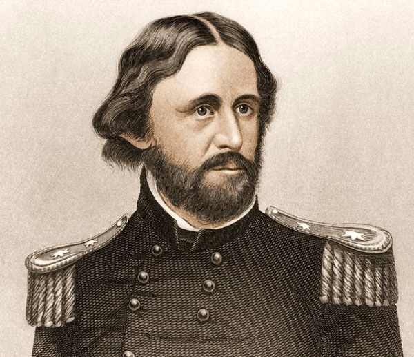
I have been meaning to look into the history of Fremont for some time. He is responsible for naming much of the west and his name shows up frequently on my trips.
John Charles Frémont or Fremont (January 21, 1813 – July 13, 1890) was an explorer of the Western United States
He is known as The Path Finder of the Rocky Mountains
- Oregon Trail s.jpg (2.46 MiB) Viewed 572 times
Anchor Dates
• American Civil War Apr 12, 1861 – Apr 9, 1865
• The Transcontinental Railroad was constructed between Dec 1863 and May 10, 1869
• The California Gold Rush began on January 24, 1848, when gold was found by James W. Marshall at Sutter's Mill in Coloma.
• Lost 49er arrived in Death Valley Christmas eve 1849.
In the 1840s, Frémont led five expeditions into the Western United States.
His reports gave many their first knowledge of what is now the many states of the American West, and his work won for him the nickname of “Pathfinder.”
When Joel Poinsett became Secretary of War, he arranged for Frémont to assist French explorer and scientist Joseph Nicollet in exploring the lands between the Mississippi and Missouri rivers for 10 years.
As a result, Frémont became a first-rate topographer, trained in astronomy, and geology, describing fauna, flora, soil, and water resources.
- JohnFremont.jpg (77.91 KiB) Viewed 571 times
In 1841, Frémont Married Senator Benton’ daughter Jessie. Senator Thomas Hart Benton of Missouri was the powerful chairman of the Senate Committee on Military Affairs.
Benton pushed appropriations through Congress for national surveys of the Oregon Trail, the Oregon Country, the Great Basin, and Sierra Nevada Mountains to California. Through his power and influence, Senator Benton obtained for Frémont the leadership, funding, and patronage of three expeditions.
He was a U.S. Senator from California, and in 1856 was the first Republican nominee for President of the United States and founder of the California Republican Party when he was nominated.
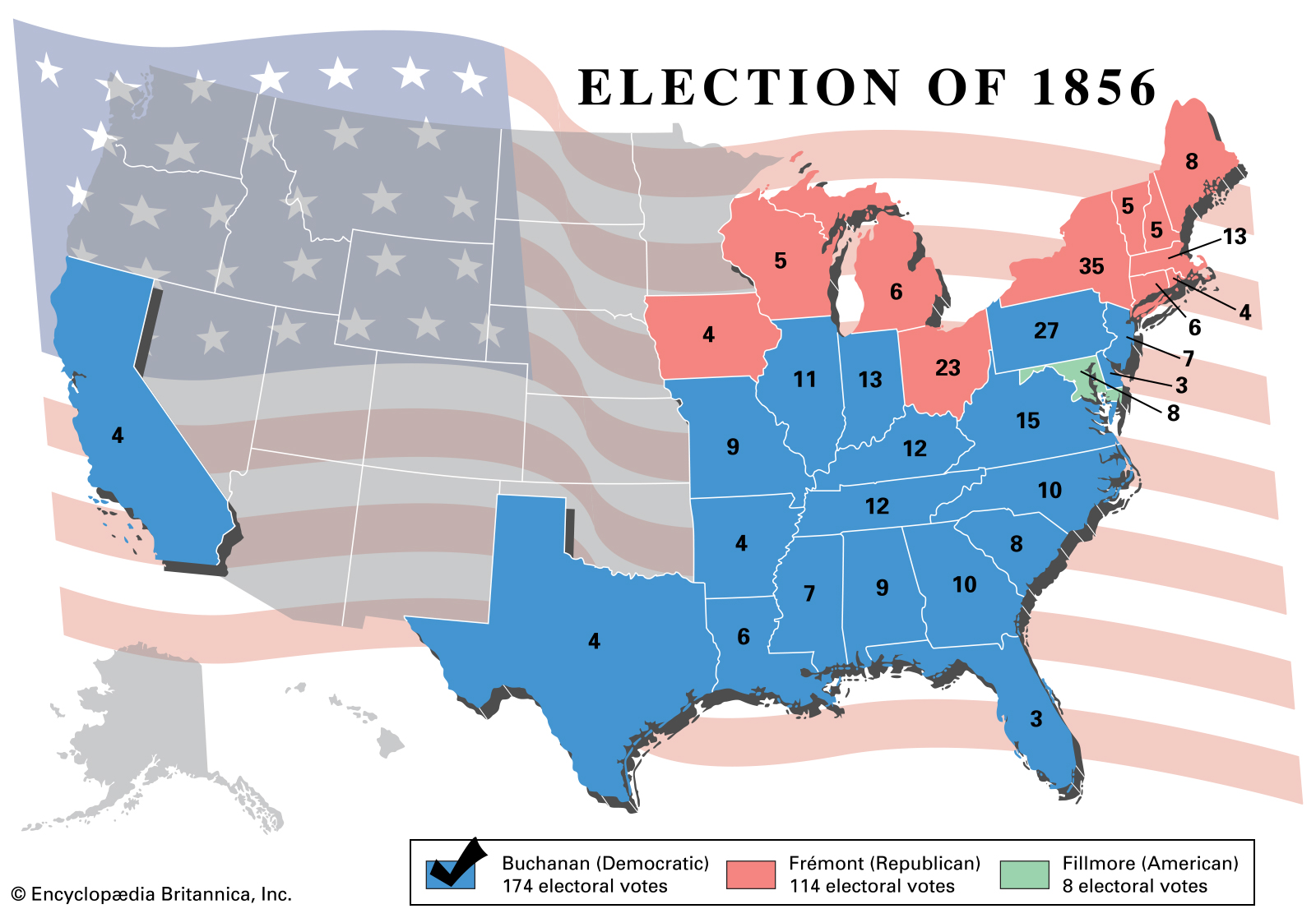
- election-Results-American-Votes-Party-Candidate-vote-1856.jpg (521.1 KiB) Viewed 570 times
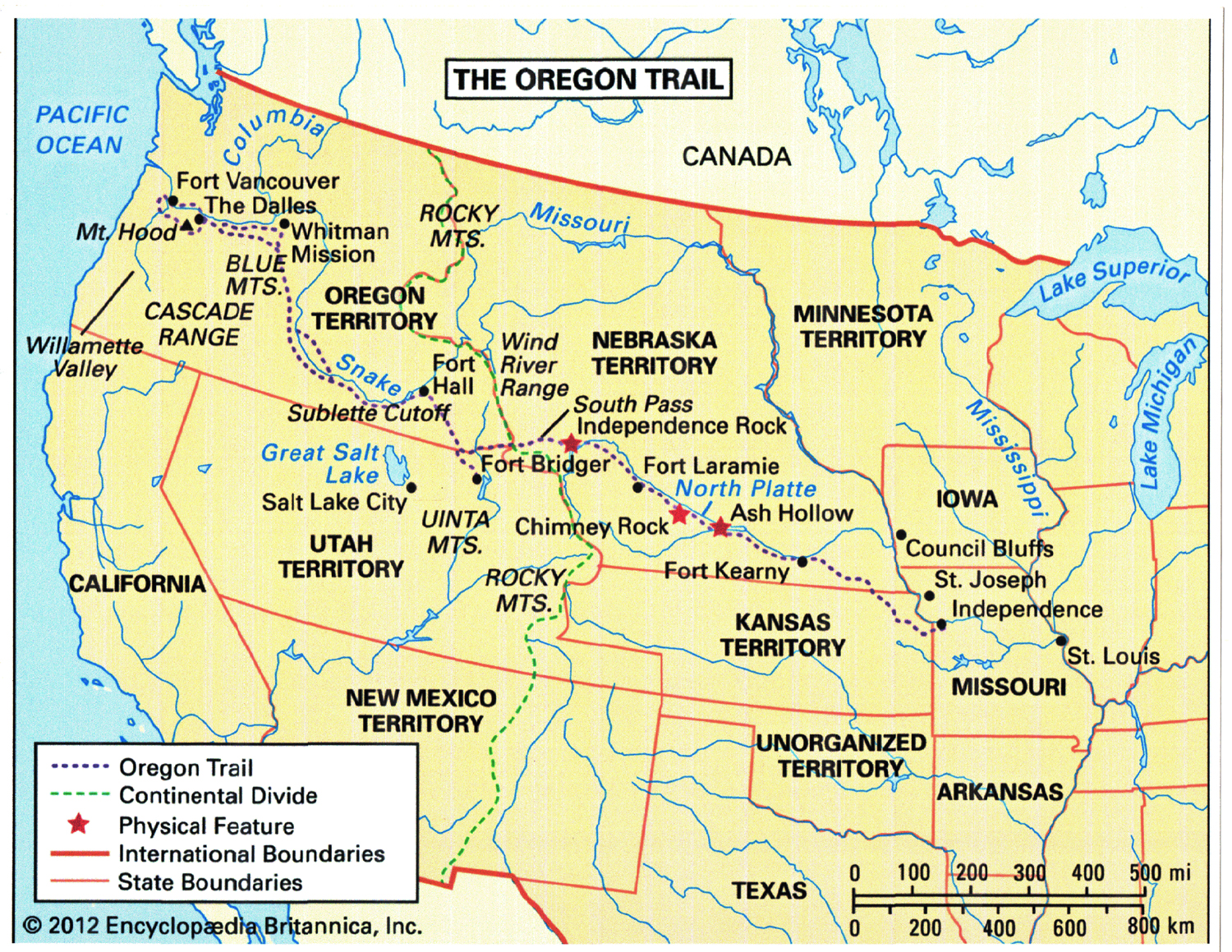
First expedition (1842) June - October
When Nicollet was too ill to continue any further explorations, Frémont was chosen to be his successor.
His first important expedition was planned by Senator Benton, his father-in-law, and other Westerners interested in acquiring the Oregon Territory.
The scientific expedition started in the summer of 1842 and was to explore the
• Wind River of the Rocky Mountains,
• examine the Oregon Trail through the South Pass,
• and report on the rivers and the fertility of the lands, find optimal sites for forts, and describe the mountains beyond in Wyoming.
Frémont was able to have mountain man and guide Kit Carson on the expedition.
Frémont and his party of 25 men, including Carson, embarked from the Kansas River on June 15, 1842, following the Platte River to the South Pass, and starting from Green River he explored the Wind River Range.
Frémont climbed a 13,745-foot mountain, Frémont's Peak, planted an American flag, claiming the Rocky Mountains and the West for the United States.
His five-month exploration was a success, returning to Washington in October.
Frémont and his wife Jessie wrote a Report of the Exploring Expedition to the Rocky Mountains (1843), which was printed in newspapers across the country; the public embraced his vision of the west not as a place of danger but wide open and inviting lands to be settled.
Fremont Peak
is the third highest peak in the state of Wyoming.
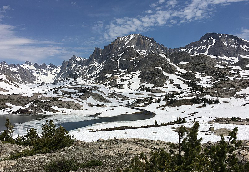
- Fremont Peak Wind River Range.jpg (462.12 KiB) Viewed 570 times
The peak is located on the Continental Divide and is the second highest peak in the remote Wind River Range after Gannett Peak.
South Pass (elevation 7,412 ft and 7,550 ft)
South Pass is the term for two mountain passes on the Continental Divide, in the Rocky Mountains in southwestern Wyoming.
The Pass lies in southwestern Fremont County, approximately 35 miles SSW of Lander.
Though it approaches a mile and a half high, South Pass is the lowest point on the Continental Divide between the Central and Southern Rocky Mountains. The passes furnish a natural crossing point of the Rockies.
Fremont culture or Fremont people
Fremont Culture is a pre-Columbian archaeological culture which received its name from the Fremont River in the U.S. state of Utah, where the culture's sites were discovered by local indigenous peoples like the Navajo and Ute.
In Navajo culture, the pictographs are credited to people who lived before the flood.
The Fremont River itself is named for John Charles Frémont, an American explorer.
It inhabited sites in what is now Utah and parts of Nevada, Idaho and Colorado from AD 1 to 1301 (2,000–700 years ago[1]).
It was adjacent to, roughly contemporaneous with, but distinctly different from the Ancestral Pueblo peoples located to their south.
Fremont people generally wore moccasins like their Great Basin ancestors rather than sandals like the Ancestral Puebloans.
They were part-time farmers who lived in scattered semi-sedentary farmsteads and small villages, never entirely giving up traditional hunting and gathering for more risky full-time farming. They made pottery, built houses and food storage facilities, and raised corn, but overall they must have looked like poor cousins to the major traditions of the Greater Southwest, while at the same time seeming like aspiring copy-cats to the hunter-gatherers still living around them
Second expedition (May 1843 – Aug 1844)
The more ambitious goal was to
• map and describe the second half of the Oregon Trail,
• find an alternate route to the South Pass,
• and push westward toward the Pacific Ocean on the Columbia River in Oregon Country.
Frémont obtained a 12-pound howitzer cannon in St. Louis.
Frémont invited Carson on the second expedition
Unable to find a new route through Colorado to the South Pass, Frémont took to the regular Oregon Trail.
His party stopped to explore the northern part of the Great Salt Lake.
He mapped Mount St. Helens and Mount Hood.
They reached Sutter's Fort in the Sacramento Valley in March 1844
Frémont resolved to explore the Great Basin between the Rockies and the Sierras.
- Great Basin.jpg (38.43 KiB) Viewed 570 times
Frémont and his party turned south along the eastern flank of the Cascades through the Oregon territory to Pyramid Lake, which he named.
Looping back to the east to stay on the eastern side of the Sierra Nevada mountain range, they turned south again as far as present-day Minden, Nevada, reaching the Carson River on January 18, 1844.
From an area near what later became Virginia City, Frémont turned west into the cold and snowy Sierra Nevada, becoming one of the first Americans to see Lake Tahoe.[22]
Carson successfully led Frémont's party through a new pass over the high Sierras, which Frémont named Carson Pass in his honor.
Frémont and his party then descended the American River valley to Sutter's Fort at present-day Sacramento, California, in early March
Exploring the Great Basin, Frémont verified that all the land (centered on modern-day Nevada between Reno and Salt Lake City) was endorheic, without any outlet rivers flowing towards the sea.
It disproved a longstanding legend of a 'Buenaventura River' that flowed out the Great Basin across the Sierra Nevada.
After exploring Utah Lake.
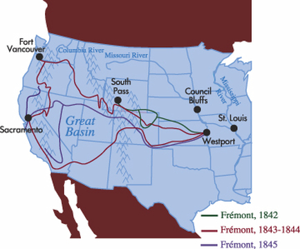
- map-fremont.jpg (107.61 KiB) Viewed 570 times
In August 1844, Frémont and his party finally arrived back in St. Louis.
His wife Jessie and Frémont returned to Washington, where the two wrote a second report, scientific in detail, showing the Oregon Trail was not difficult to travel and that the Northwest had fertile land.
Senator Buchanan ordered the printing of 10,000 copies to be used by settlers and desire the popular movement of national expansion.
Fremont Island
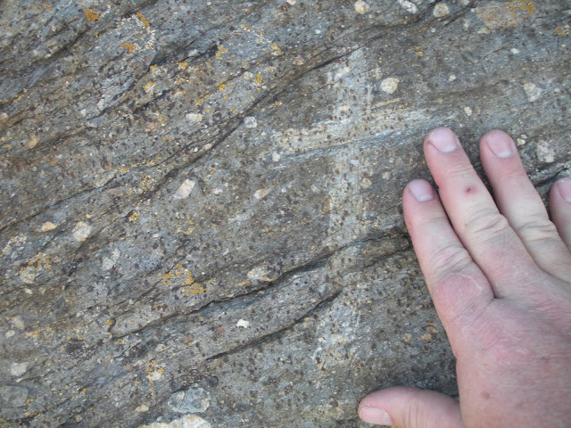
- Fremont Island Trip (58).jpg (131.93 KiB) Viewed 567 times
located in Great Salt Lake
Named Disappointment Island by Fremont
Kit Carson inscribed a cross on the highest point on the island.
It was renamed Fremont Island in 1850, when Capt. Howard Stansbury surveyed the Great Salt Lake.
Lost Cannon
Fremont expedition of 1843 – 1844
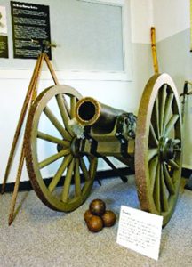
- Freemont-Cannon1-216x300.jpg (17.01 KiB) Viewed 570 times
Abandoned during a snowstorm in the Sierra Nevada mountains in 1844 by John C. Fremont. Otherwise known as the Fremont Cannon, this priceless artifact has been sought by treasure hunters, archaeologists, Forest Service employees and others for 170 years.
October 31st of 2013, the remains of the lost Fremont Cannon were unveiled at the Nevada State Museum.
Also included were many other artifacts, found in Deep Creek near the West Walker River where Fremont said he had abandoned the cannon.
A model M1835 bronze cannon (mountain howitzer), cast by the Cyrus Alger Iron Company in South Boston, Massachusetts. Only thirteen of the model M1835 mountain howitzer barrels were cast
The trophy when Nevada plays at UNLV is a replica of Fremont’s cannon.
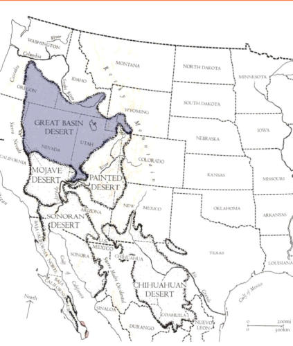
Great Basin
After arriving in Oregon, however, Fremont made the decision to return by a different route that would take him south into the Great Basin of Nevada in search of the legendary Buenaventura River believed by many to cross the Sierra Nevada Mountains to the Pacific Ocean. He was thus the first person to prove that no such river existed and coined the term Great Basin to describe the area.
- Great Basin.jpg (38.43 KiB) Viewed 570 times
Third expedition (June 1845)
With the backdrop of an impending war with Mexico, after James K. Polk had been elected president, Benton quickly organized a third expedition for Frémont.
The plan for Frémont under the War Department was to
• survey the central Rockies,
• the Great Salt Lake region, and
• part of the Sierra Nevada.
Back in St. Louis, Frémont organized an armed surveying expedition of 60 men, with Carson as a guide.
Working with Benton and Secretary of Navy George Bancroft, Frémont was secretly told that if war started with Mexico, he was to turn his scientific expedition into a military force.
President Polk was set on taking California. Frémont desired to conquer California for its beauty and wealth, and would later explain his very controversial conduct there.
On June 1, 1845, Frémont and his armed expedition party left St. Louis having the immediate goal to locate the source of the Arkansas River, on the east side of the Rocky Mountains. Frémont and his party struck west by way of Bent's Fort, The Great Salt Lake, and the "Hastings Cut-Off".
In 1846, Frémont sill in California and a major in the U.S. Army, took control of California During the Mexican–American War.
Frémont was convicted in court-martial for mutiny and insubordination after a conflict over who was the rightful military governor of California. After his sentence was commuted and he was reinstated by President Polk, Frémont resigned from the Army.


