Donate

OAUSA Net - 5/18/23 and 6/1/23 - Wilderness Communications I & II

A preview of future nets
User avatar
DaveK
Site Admin
Posts: 3849
Joined: Tue Mar 11, 2008 10:33 am
Call Sign: K6DTK
Location: American Southwest

OAUSA Net - 5/18/23 and 6/1/23 - Wilderness Communications I & II

Post by DaveK » Tue May 16, 2023 8:43 pm

Wilderness Communications I & II

The topic of wilderness communications is one of our favorites, and one that we have regularly covered in the past. It is a favorite topic because it gives us a chance to discover new radios, and other gadgets that have expanded our ability to communicate. New technology means new products, which means new toys that we MUST have. The subject matter here is large and important, so we hold out the possibility of a second net, if necessary.

This week, we intend explore the many options for communication once you have traveled beyond the range of the trusty cell phone. In our experience, it seems like cell phones quit working just about the time we hit dirt. To some extent, that has changed, but the reality is that no cell phone carrier who cares to make a profit, is going to provide coverage to vast areas of land on which there are never more than a handful of people.

That means, of course, that the well prepared traveler carries the means to communicate regardless of where the trail takes him. Some communication options work better than others, some are expensive, and some are meant for very specific applications, but you should never leave home with out the ability to reach out for help. While cell phones may be adequate for short trips, near cell towers, it is the remote location adventures where trip plans must include the right equipment.

No net on this topic would be complete with the stories about how we were able to communicate while many hundreds of miles from civilization, and without the benefit of the internet.

While we know that it is not safe to travel alone, we know it happens, and in those cases, the ability to get help is most important, assuming that your injuries are not such that you cannot make the call. Although it may seem obvious, it bears repetition that when you travel in a group, there (hopefully) will be others who have the means to make an emergency call when you can't.

Having the ability to get help in emergencies is clearly the most important reason to have the right equipment, but there are many others. Here are some examples:
  • vehicle to vehicle communication on the highway and on the trail
  • keeping track of vehicles in caravans
  • assisting late arriving members of the group to find camp
  • communicating with other Hams in the areas traveled
  • sending pictures and trip reports home
  • keeping family members advised of your trip progress and location
  • preparation for emergencies at home
  • requesting and receiving information, (e.g. radio operation, , weather, menus, vehicle repair info, etc.)
  • For the HF crowd, the ability to appreciate the benefits of night time operation
Time permitting, we will cover the following topics:

1. New developments in communications
Pactor 4
FRS / GMRS

2. Ham Radio
VHF / UHF
HF
Airmail

3. APRS

4. Satellite Comms
Spot, In Reach
PLBs
Satellite phones
BGAN

5. Value of redundancy and having multiple options available (including multiple users)

6. Trip prep

7. Value of radio operation knowledge, operators manuals, spare parts, radio programming software, analyzers, etc.

Communicating in the wilderness:

Hammin-3.JPG
Hammin-3.JPG (62.84 KiB) Viewed 3773 times
Hammin-6.JPG
Hammin-6.JPG (135.75 KiB) Viewed 3773 times
DaveK
K6DTK


Extremism in the defense of liberty is no vice.
Moderation in the pursuit of justice is no virtue.

User avatar
DaveK
Site Admin
Posts: 3849
Joined: Tue Mar 11, 2008 10:33 am
Call Sign: K6DTK
Location: American Southwest

Re: OAUSA Net - May 18, 2023 - Wilderness Communications

Post by DaveK » Tue May 16, 2023 10:04 pm

Radio Email

Background

Having Ham radios on board is a must for any trip. Being licensed Amateur Radio operators, we have always relied on our radios as the core of our wilderness comms, and it includes both our HF rigs as well as our VHF or UHF radios. And, the list would not be complete without including our handheld transceivers (HTs.) Amateur Radio is built on the concept of innovation, and the results have been a non-stop flow of new and better communication devices which have kept Amateur Radio alive and well.

We will cover the specific topic of Ham radios in the following segments, but this one will deal with what I believe is one of the most important tools that we have at our disposal for communicating in the wilderness = HF Email.

In countless ways, we have at our disposal some of the most effective communications options ever, including the In Reach satellite communicator, the Spot satellite communicator, Personal Locator Beacons (PLBs), Garmin's GPS radios, and others. This is all on top of the various Amateur Radio options as well as GMRS and FRS radios. Each has its unique benefits, and those benefits make them good options for remote location communications.

Radio Email

This segment deals with the use of traditional Ham radios combined with the new technology of Pactor modems (or controllers, as SCS calls them.) Using a system known as Winlink, it is possible to send regular emails, without an internet connection, from just about anywhere in the world. For our wilderness travels, this is a very attractive option. Winlink describes itself:
Winlink Global Radio Email (https://winlink.org/)
...is a network of amateur radio and authorized government stations that provide worldwide radio email using radio pathways where the internet is not present. The system is built, operated and administered entirely by licensed "Ham" volunteers. It supports email with attachments, position reporting, weather and information bulletins, and is well-known for its role in interoperable emergency and disaster relief communications. It is capable of operating completely without the internet--automatically--using smart-network radio relays. Licensed Winlink operators/stations use both amateur radio and government radio frequencies worldwide. Support for the system is provided by the Amateur Radio Safety Foundation, Inc., a US 501(c)(3) non-profit, public-benefit entity.
The benefits of Radio email:
  • It can send and receive regular emails to anyone in the world who has an email address
  • It works in areas where no internet connection is available
  • Those to whom an email is sent do not need to be licensed Amateur Radio operators
  • Those who receive such an email can respond even if they are not licensed Amateurs
  • The system relies on HF radios, and anywhere an HF signal is possible, emails can be sent and received.
  • Family and friends can be updated on all your travels with location information, change in plans, return home information, etc.
  • The one feature that no other form communication offers - the ability to send pictures.
Once set up, and depending on the version of your Pactor Controller, the time it takes to send and receive emails is virtually the same as emails at home.

The SCS Company, the creator and manufacturer of Pactor modems, began development in the late 80s, with the first generation now referred to as P1. Subsequent to that, the P2 model and P3 models were introduced, and all 3 generations are legal for use by the Ham radio community. The P3, of course, being the fastest of the three. SCS say this about P3:
PACTOR-3 provides outstanding performance under poor and moderate signal conditions. As PACTOR-3 also achieves very high throughput rates under good signal conditions, it is well-suited to HF channels with good SNR and low signal distortion as well. During the development of PACTOR-3, high importance was attached to compatibility with ordinary SSB transceivers (using standard 2.2- 2.4 kHz wide IF-filters). Therefore, PACTOR-3 can achieve its maximum speed with using unmodified, common SSB transceivers. The occupied bandwidth is around 2200 Hz. Thus PACTOR-3 is the ideal means of fast and reliable data communication over (the sometimes difficult medium) HF-radio. The new protocol is fully backwards compatible to
existing PACTOR-1/2 networks. The properties of the PACTOR-3


Beginning in 2006 SCS began development of the P4 Pactor Controller, retaining all the qualities of the P3, but with the benefit of significantly increased computation power, transfer speed, and robustness, the most significant of which was a transfer speed increase of 200%, while still maintaining the bandwidth of the legal P3. This 4th generation of Pactor Controllers offers email speeds nearly identical to that of your email at home. They look like this:

Pactor 4 Dragon.png
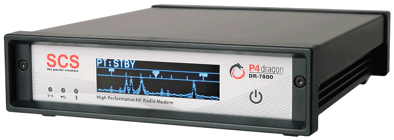
Pactor 4 Dragon.png (306.89 KiB) Viewed 3766 times
Pactor4 7400.png
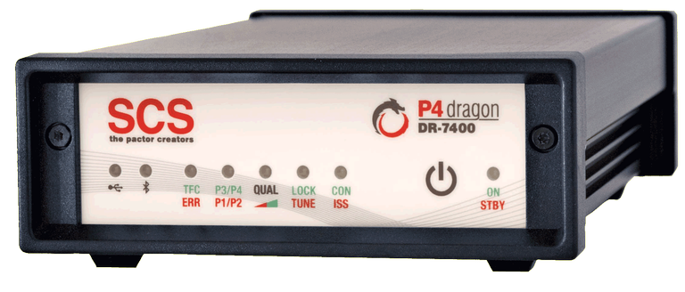
Pactor4 7400.png (318.34 KiB) Viewed 3766 times


Pactor 4 has the greatest capabilities of the Pactor line, as seen by this chart:

P1 vs P4 Speed-1.jpg
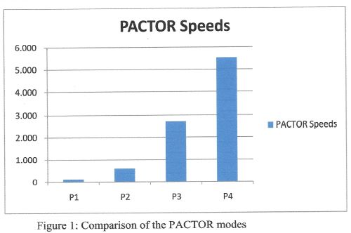
P1 vs P4 Speed-1.jpg (18.67 KiB) Viewed 3766 times


Despite the identical bandwidth of P3 and P4, the FCC has failed to approve it's use in the United States, even though it is legal in other countries by their Amateur communities. One would think that the Amateur community would welcome a major improvement such as this, as would the FCC. Oddly, the FCC and the Amateur community (more on the net) do in fact, support approval, but the FCCs failure to act remains a mystery. And, here's why:
  • 2011 SCS introduces the P4
  • 2013 - ARRL files a Petition for Rile Making, supporting approval
  • 2016 - the FCC issues a Notice of Proposed Rule Making (NPRM) supporting approval
  • 2016-2023 - The FCC has granted temporary approval to use P4 during natural disasters

In the 7 years following the FCCs NPRM, it has done exactly NOTHING to grant full approval of the P4 . A mystery without an explanation. Finally, last year, Representative, Lesko (Rep. AZ) introduced legislation to force the FCC to make good its intent as set out in the 2016 NPRM. She followed it up this year with HR3241, a resolution to force the FCC to legalize the P4 controllers, and that resolution is currently in committee. It's been 10 years since the original ARRL Petition was filed. Enough is enough.

In addition to keeping family and friends updated on our condition and progress, I have used the Winkink System to provide pictures to other members of OAUSA to be posted here on this website.

Here are some examples of pictures that I've sent using Winlink:

Airmail Picture 3.JPG
Airmail Picture 3.JPG (44.3 KiB) Viewed 3766 times
Airmail Picture 2.JPG
Airmail Picture 2.JPG (50.39 KiB) Viewed 3766 times
Airmail Picture 1.JPG
Airmail Picture 1.JPG (51.55 KiB) Viewed 3766 times

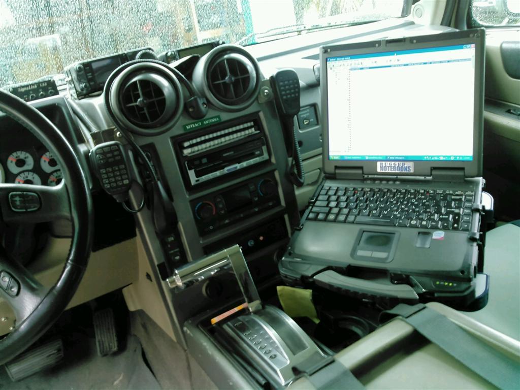
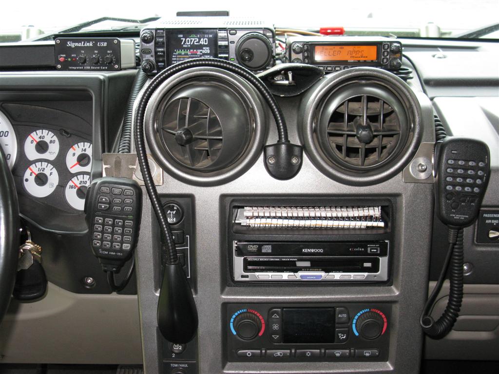
The Radio Email Set-up

Everything that is needed to utilize all of the benefits of Ham Radio for UHF, VHF and HF are present in these pictures, including the GPS (which feeds position information to the computer, the computer itself, with all programming for APRS, Airmail, and all navigation programs, and the Pactor Modem. Note: (The Pactor Modem is concealed behind the computer, but it's there, honest!)

DTK Set-up.jpg
DTK Set-up.jpg (107.86 KiB) Viewed 3766 times
DTK radios.JPG
DTK radios.JPG (130.68 KiB) Viewed 3766 times
DaveK
K6DTK


Extremism in the defense of liberty is no vice.
Moderation in the pursuit of justice is no virtue.

User avatar
DaveK
Site Admin
Posts: 3849
Joined: Tue Mar 11, 2008 10:33 am
Call Sign: K6DTK
Location: American Southwest

Re: OAUSA Net - May 18, 2023 - Wilderness Communications

Post by DaveK » Wed May 17, 2023 1:08 pm

AMATEUR RADIO

For the Amateur community, for the most part, no case needs to be made for the value of your radio. When it comes to long distance communication, reliability, limitless options for operation, a huge variety of equipment, and a great number of fellow Hams across the country who will help out, there is no equal to this means of communication.

Ham Radio HF frequencies make it possible to communicate over thousands of miles, and in the most remote areas, and the deepest canyons. It is humorous to watch those who are unfamiliar with Ham Radio, dismiss it's effectiveness without any real understanding of what it can do. Much of this willingness to eliminate Ham Radio from consideration, IMHO, is due to a certain slavish devotion to the almighty cell phone. Unfortunately, when it's too late, the cell-phone-is-king crowd is forced to realize it's shortcomings. Enter Ham Radio!

By far, the most important benefit of Ham radio is the means to seek help. Secondarily, it serves as a means to communicate for the many reasons mentioned in post number 1, above, all of which we will discuss during the net. Discussion and stories on these topics:

VHF/UHF - vehicle to vehicle, contact local and distant repeaters, connect to IRLP nodes, directing late comers to camp
HF - communications over thousands of miles
HTs - cross band repeater, hiking trail communication, finding lost hikers

Shots Of Mobil HF/UHF/VHF/Airmail Rigs

Comms on the Rim-2.JPG
Comms on the Rim-2.JPG (149.71 KiB) Viewed 3765 times
Comms on the Rim.JPG
Comms on the Rim.JPG (162.47 KiB) Viewed 3765 times
Attachments
Scorpion Antenna.JPG
Scorpion Antenna.JPG (103.96 KiB) Viewed 3765 times
DaveK
K6DTK


Extremism in the defense of liberty is no vice.
Moderation in the pursuit of justice is no virtue.

User avatar
DaveK
Site Admin
Posts: 3849
Joined: Tue Mar 11, 2008 10:33 am
Call Sign: K6DTK
Location: American Southwest

Re: OAUSA Net - May 18, 2023 - Wilderness Communications

Post by DaveK » Wed May 17, 2023 1:09 pm

APRS

Briefly, APRS is a means to report the coordinates of your position, even when traveling, so that others can know where you are. This position data can be transmitted either to other nearby users or to the internet. In short, it is a way of keeping track of APRS users.

For our purposes, there are two APRS devices that we will discuss on the net:
  • Vehicle mounted APRS
  • Portable APRS via a hand held transceiver (aka walkie talkie)
Keep in mind that for this discussion we will only deal with APRS for VHF. For those who are properly equipped and who want the ultimate in APRS, there is a version of this that utilizes Ham HF Frequencies, resulting in significantly increased range. There are some definite challenges and limitations in the HF version, but it does offer users a singular means to communicate.

How it works

APRS data is transmitted from your Ham radio to digipeaters, (much like a repeater) which in most cases, serve as internet gateways. Once it hits the internet, it is available world wide. So, as you travel, your position (and other information) becomes available to anyone with access to the internet. In these cases, the digipeater will usually take the form of high level repeaters (high level meaning repeaters located at high elevation.)

This same position information can be received by other nearby APRS users who can then place your position on vehicle mounted computers (running the appropriate mapping software.) This benefit allows groups to know the positions of all other members who are also running APRS.

The benefits of APRS involve both communications and navigation, and we will deal with them both during the net. Briefly, here are some of the communications benefits of APRS:

1. Allows traveling groups to keep track of everyone in the group
2. Allows family and friends back home to know your exact location
3. Allows rescue operators to know your location in the event of an emergency
4. Allows users to send email messages to anyone
5. Allows users to send text messages to others in the group or at home
6. Allows late arriving members of your group to locate your camp or the traveling group.
7. Allows retrieval of your complete trip tracks for trip reports and future planning

Here are some of the Navigation benefits of APRS:

1. Can use most maps, especially USGA Topos.
2. Allows drivers to pre-plan the trip by annotating the maps.

Some examples of APRS systems:

Different APRS maps
Note: The first is a USGS TOPO map I made of an area on the North Rim of the Grand Canyon, called Twin Point. The blue line represents our actual track.

APRS Navigation 3.jpg
APRS Navigation 3.jpg (203.4 KiB) Viewed 3765 times
APRS Navigation 2.jpg
APRS Navigation 2.jpg (106.24 KiB) Viewed 3765 times
APRS Navigation 1.jpg
APRS Navigation 1.jpg (199.3 KiB) Viewed 3765 times
DaveK
K6DTK


Extremism in the defense of liberty is no vice.
Moderation in the pursuit of justice is no virtue.

User avatar
DaveK
Site Admin
Posts: 3849
Joined: Tue Mar 11, 2008 10:33 am
Call Sign: K6DTK
Location: American Southwest

Re: OAUSA Net - May 18, 2023 - Wilderness Communications

Post by DaveK » Wed May 17, 2023 1:11 pm

ALTERNATE COMMS

Satellite Messengers

Spot X

This is Spot's has some very impressive features. This unit bears a striking resemblance to the Blackberry cell phone with its individual alpha/numeric buttons. Very nice touch, and it sure speeds up texting. Here is what they say (https://www.findmespot.com/en-us/produc ... x#overview)
SPOT X provides 2-way satellite messaging when you’re off the grid or beyond reliable cellular coverage. Connect SPOT X to your smart phone via Bluetooth wireless technology through the SPOT X app to access your contacts and communicate easily with family, friends, or directly with Search & Rescue services in a life-threatening situation. If preferred or when necessary, SPOT X can be used as a standalone communication device. SPOT X has its own dedicated U.S. mobile number, so others can message you directly at any time.
Spot.png
Spot.png (36.8 KiB) Viewed 3759 times
Source: Spot


Garmin In Reach

Another satellite messaging device, also with a lot of very impressive features. Here is what they say (https://buy.garmin.com/en-US/US/p/561269)
Rugged handheld satellite communicators enable two-way text messaging via 100% global Iridium® satellite network (satellite subscription required.) Trigger an interactive SOS to the 24/7 search and rescue monitoring center. Track and share your location with family and friends. Pair with compatible mobile devices using the free Earthmate® app for access to downloadable maps¹, U.S. NOAA charts, color aerial imagery and more. inReach Explorer+ device adds preloaded DeLorme® TOPO maps with onscreen GPS routing plus built-in digital compass, barometric altimeter and accelerometer
Garmin In Reach.jpg
Garmin In Reach.jpg (24.44 KiB) Viewed 3759 times
Source: Garmin


McMurdo Fast Find 220 PLB

Personal location beaconing devices have been around for a long time, and for a very good reason - they work and work well. A PLB is a personal safety device designed to alert search and rescue services and allow them to quickly locate you in the event of an emergency, on land or sea.

From Seas of Solutions (https://www.seasofsolutions.com/product ... tfind-220/)
McMurdo FastFind 220
The 220 is the world’s first Galileo-enabled Personal Location Beacon (PLB), which is a personal safety device designed to alert search and rescue services and allow them to quickly locate you in the event of an emergency, on land or sea.

Features
  • 406/121.5MHz PLB
  • Galileo & GPS GNSS receivers
  • Easy to operate
  • No subscription needed
  • High brightness LED SOS light
  • Minimum 24hr continuous operation
  • 6 year battery storage life
  • Self test facility with battery use indicator
  • Supplied with flotation pouch
McMurdo-FastFind-220.jpg
McMurdo-FastFind-220.jpg (18.99 KiB) Viewed 3760 times
Source: Seas of Solutions
DaveK
K6DTK


Extremism in the defense of liberty is no vice.
Moderation in the pursuit of justice is no virtue.

User avatar
toms
OAUSA Board Member
Posts: 951
Joined: Wed Mar 12, 2008 11:50 am
Call Sign: KI6FHA
Location: Redondo Beach CA (5 miles south of LAX)
Contact:

Re: OAUSA Net - May 18, 2023 - Wilderness Communications

Post by toms » Wed May 17, 2023 4:34 pm

Satellite Phone

The main advantage of a Satellite phone is the ability to make a call and talk to someone in remote areas with no cell service. The major disadvantage is the cost of the service and the phone. Costs are coming down. The phone is almost affordable and is a one-time cost. The Global Star phone is about $500 one-time charge.

I purchased an earlier version of the Global Star phone for $250 and for $51.68. I was grandfathered with unlimited minutes in the USA.
The service is not instant but once a connection is made, it hangs on for sufficient time to have a conversation.

Since then, the phones have been improved greatly. I have no experience with any of these.
The best regarded satellite phones known for their reliability, coverage, and features are:


Iridium-Extreme.png
Iridium-Extreme.png (100.3 KiB) Viewed 3763 times


1. Iridium 9575 Extreme: The Iridium 9575 Extreme is often considered one of the top satellite phones available. It offers global coverage, military-grade ruggedness, and a range of features such as voice calling, text messaging, email, GPS tracking, and an SOS button for emergencies. $800 to $1500
Iridium has a 10 minute per month plan for $64.99- extra minutes are $1.49


Inmarsat isatphone.jpg
Inmarsat isatphone.jpg (17.16 KiB) Viewed 3763 times


2. Inmarsat IsatPhone 2: The Inmarsat IsatPhone 2 is another popular choice. It provides reliable voice calling, text messaging, and basic internet connectivity. It is known for its robust build, long battery life, and ease of use. $800 to $1500

3. Thuraya X5-Touch: The Thuraya X5-Touch combines satellite and GSM/4G capabilities, offering hybrid connectivity. It features a large touchscreen display, an Android operating system, and smartphone-like functionality. It provides voice calling, messaging, email, web browsing, and access to Android apps. About $1800


gsp1700sml.jpg
gsp1700sml.jpg (12.87 KiB) Viewed 3763 times


4. Globalstar GSP-1700: The Globalstar GSP-1700 is a compact and lightweight satellite phone. It offers reliable voice calling, text messaging, and limited data capabilities. It is known for its simplicity, affordability, and coverage primarily in North America, Europe, and parts of Asia. $435
Basic service is $49.99 for 50 minutes per month or unlimited minutes for $64.99 per month. There is a $50 activation fee.

The cost-of-service plans are all over the board. You need to do your research to see which one meets your need. For most of use, the use of a satellite phone is for emergencies. So, an inexpensive plan is desirable. A satellite call can be as low as $0.50 per minute if you buy a large number of minutes in advance or as high as $7.00 per minute.
As discussed in this net, we have many other options for communication. You need to evaluate if you really need a Sat phone.
See you on the Trail!
TomS
KI6FHA / WPZW486

Badlands Off-Road
tom@4x4training.com
http://www.4x4training.com

User avatar
KK6DYO
OAUSA Board Member
Posts: 466
Joined: Thu Aug 29, 2013 9:07 pm
Call Sign: KK6DYO

Re: OAUSA Net - May 18, 2023 - Wilderness Communications

Post by KK6DYO » Thu May 18, 2023 10:25 am

FCC Personal Radio Services:
FRS (Family Radio Service) / GMRS (General Mobile Radio Service)


https://www.ecfr.gov/current/title-47/c ... t-95?toc=1

An FRS radio was my first ever. I then "graduated" to GMRS, acquiring a hybrid radio which did both FRS and GMRS. My 5-year GMRS license originally cost $85.

FRS and GMRS are UHF (ultra high frequency 462 - 467MHz) FM (frequency modulation) radio services.
FRS-GMRS Band.png
FRS-GMRS Band.png (174.77 KiB) Viewed 3743 times


In preparing for tonight's net, I was expecting to provide separate posts for FRS and GMRS. I discovered that these two services were essentially merged.


In 2017, the FCC:
  • increased the GMRS license term from 5 to 10 years
  • allowed FRS to transmit on GMRS channels 15-22
  • allowed GMRS to transmit on FRS channels 8-14
  • specified that radios can only be certified as FRS or GMRS (or MURS (Multi-Use Radio Service)); no more FRS / GMRS hybrids
  • allowed transmission of digital data:
    • location information
    • request for location information from one or more FRS or GMRS units
    • brief text message to another specific FRS or GMRS unit
    • note: did not allow digital voice encoding

FRS License
  • none required

GMRS License
  • no exam required
  • $35 for 10 years as of 2022
  • FCC-issued call sign (no vanity call signs)
  • call sign must be transmitted once every 15 minutes
    • in English language
    • in audible Morse code
  • permits use by "immediate family members"
    • spouse, children, grandchildren, stepchildren, parents, grandparents, stepparents, brothers, sisters, aunts, uncles, nieces, nephews, and in-laws
    • note: amateur radio license generally covers only an individual operator, with unlicensed users requiring the immediate supervision of the licensed “control operator” to ensure legal communication in accordance with Station Operation Standards
  • allows repeaters which can be linked to other repeaters

Channels / Frequencies
  • 462 main channels (15-22; FRS 2W, GMRS 50W wideband)
    • mobile, hand-held portable, repeater (output), base and fixed stations
    • 462.5500, 462.5750, 462.6000, 462.6250, 462.6500, 462.6750, 462.7000, and 462.7250 MHz
  • 462 interstitial channels (1-7; FRS 2W, GMRS 5W)
    • 462.5625, 462.5875, 462.6125, 462.6375, 462.6625, 462.6875, and 462.7125 MHz
  • 467 main channels (15RP-22RP; FRS none, GMRS 50W)
    • used for repeater input
    • mobile, hand-held portable, control and fixed stations (repeater input)
    • 467.5500, 467.5750, 467.6000, 467.6250, 467.6500, 467.6750, 467.7000, and 467.7250 MHz
  • 467 interstitial channels (8-14; FRS ½W with fixed antenna, GMRS ½W with fixed antenna)
    • 467.5625, 467.5875, 467.6125, 467.6375, 467.6625, 467.6875, and 467.7125 MHz

MARS (Military Auxiliary Radio Service) Modification

Some distributors (e.g., HRO) offer a "MARS Mod" for various radios. The technique for doing this for free can be searched for on Google or YouTube. This radio modification would usually extend a radio's UHF transmit capabilities into the FRS / GMRS frequency range (plus MURS).

Note: This was previously called a MARS / CAP Mod, but the Civil Air Patrol frequencies can now only be used on certified radios, not modified amateur radios. Looks like they forgot to remove the CAP reference from the description. I understand that you may need to show your MARS license to get the mod done.

It would be illegal to transmit on FRS / GMRS using such a modified amateur radio.

MARS Mod.png
MARS Mod.png (162.88 KiB) Viewed 3727 times


Dual-Band Extended Coverage Mobile Antenna

For what it's worth, Comet makes an handy mobile antenna that covers both amateur and FRS / GMRS services reasonably well should you care to install both types of mobile radios in your vehicle.

Comet CA-2x4SR.png
Comet CA-2x4SR.png (97.51 KiB) Viewed 3725 times


The Question
Question: Ham radios can often be fairly easily modifacied to extend their UHF (70 cm) operation up into the GMRS range.
  • Do I really need to carry both amateur and GMRS hand-held radios, if I need to use both ?
  • Do I really need both amateur and GMRS mobile radios installed in my vehicle?
Answer: YES.
I personally think it would be nice if the FCC permitted a single radio that covered amateur and FRS / GMRS radio services.


Typical GMRS Radio

Midland GXT1000VP4 GMRS Two Way Radio

I've had two similar Midland radios for many years. Real workhorses. Well deserved ratings.

Midland GMRS.png
Midland GMRS.png (301.61 KiB) Viewed 3721 times


Garmin Rino

The Garmin Rino, currently in 4 models ranging from $350 to $650, combines GPS capabilities and map display with a GMRS radio. The most interesting feature is its ability to transmit and receive location information with other Rino units, like a built-in APRS, and show the locations of other units on a map display. It does this with an audible digital burst at the end of each transmission. From one unit you could also "ping" other units, getting them to send their locations.

What's not to like? They're expensive. The display isn't very high resolution at 240x400 while iPhones are around 1200x2400. Garmin maps are expensive. Garmin map updates are expensive. Garmin BaseCamp software, running on both PC and Mac, is adequate, but I never found it user friendly.

(Note: GPS File Depot provides free maps of various quality which can be downloaded to Garmin devices. The Desert Southwest map is great, though the 2013 version is now dated.)

Still, this is a fairly unique device.

Garmin Rino.jpg
Garmin Rino.jpg (41.62 KiB) Viewed 3689 times

User avatar
KK6DYO
OAUSA Board Member
Posts: 466
Joined: Thu Aug 29, 2013 9:07 pm
Call Sign: KK6DYO

Re: OAUSA Net - May 18, 2023 - Wilderness Communications

Post by KK6DYO » Thu May 18, 2023 1:40 pm

Satellite Internet Services

Once you have Internet access, you can communicate via all of the standard ways: voice, text, email, posting to social media :lol:, whatever.

There are three major services which provide Internet access via satellites.

Two services (HughesNet and Viasat) use geosynchronous satellites in high Earth orbit, which has two drawbacks:
  • signals must travel to the satellite (22,000 miles up) and back resulting in latency (i.e., slower service)
    • even at the speed of light (186,000 miles/second), the 44,000 miles space leg of the signal path immediately adds a minimum of ¼ second
  • the antenna dish must be carefully re-oriented to a satellite whenever the antenna is moved

Starlink uses moving (5 miles/second) satellites in low earth orbit
  • only 342 miles up, so much less latency
  • uses a phased array antenna (not a dish) which can
    • automatically physically orient itself to the best physical orientation
      • there may be a service delay while the antenna physically orients
    • automatically electronically tracks moving satellites without physically moving

In theory, if all parties with a group are traveling in close proximity, they might all be connected on the same WiFi network, and could communicate with each other in addition to using Internet access. May require a WiFi signal booster or extender. This is probably less likely with the high Earth orbit services since the antenna orientation would need to constantly change. Starlink Roam can be used while in-motion.

Obstructions (trees, hills, rain, clouds) can disrupt or slow service.

Satellite Internet Services.png
Satellite Internet Services.png (55.34 KiB) Viewed 3706 times

Note that Starlink has no contract. Service is acquired for one-month periods and may be paused at any time. A high performance antenna is available for $2,500.

A standard Starlink setup outdoors showing the satellite (dish like) and WiFi (monolith) antennas. A Jackery power station and solar panel were also used.
Starlink Setup.jpg
Starlink Setup.jpg (393.54 KiB) Viewed 3697 times

User avatar
KK6DYO
OAUSA Board Member
Posts: 466
Joined: Thu Aug 29, 2013 9:07 pm
Call Sign: KK6DYO

Re: OAUSA Net - May 18, 2023 - Wilderness Communications

Post by KK6DYO » Thu May 18, 2023 3:44 pm

APRS Mobilinkd

Dave has already covered APRS. One device that makes it fairly easy and cheap to use is the Mobilinkd TNC4.

TNC4.jpg
TNC4.jpg (55.04 KiB) Viewed 3685 times

This $150 "terminal node controller" is able to decode APRS digital signals coming from a radio and provide the decoded result via Bluetooth to an app running on another device whether phone, tablet, laptop.

It requires a proprietary cable ($12 - 24) connected from the TNC4 to a radio's mic / speaker jack[s]. After setting up a few parameters about your radio, it can then interface with a various applications both on Android and iOS. I have a very old Android phone loaded with APRSdroid software (Android only) which receives APRS information via the TNC from my also very old Kenwood TH-D710 and displays it on a map.

High quality recently updated maps can be obtained for free (donation requested) from OpenAndroMaps

Here's a map display of three of us on APRSdroid south of Hanksville, UT with location information from two (K6DTK and KD6GCO) received via APRS.
APRSdroid Use.jpg
APRSdroid Use.jpg (104.64 KiB) Viewed 3685 times

Here's an 8W Baofeng radio cabled to an older Mobilinkd TNC velcroed on the back. A phone or tablet running an app (e.g., aprs.fi) would process information from the TNC.
Baofeng with TNC.jpg
Baofeng with TNC.jpg (124.5 KiB) Viewed 3683 times

Unrelated to the Mobilinkd, here's a trip that aprs.fi captured of me going across the Bradshaw Trail. The red dots mark locations at which my APRS transmissions (50W) ended up back in Finland through some series of digipeaters.
Bradshaw Trail APRS Coverage.jpg
Bradshaw Trail APRS Coverage.jpg (431 KiB) Viewed 3681 times

I haven't looked recently, but the biggest issue on iOS is that as yet none of the APRS apps support downloading maps. I've talked with the Gaia and Topo Maps+ folks about supporting APRS, but the market just isn't big enough.

User avatar
KA9WDX
Posts: 247
Joined: Thu Oct 20, 2016 7:40 pm
Call Sign: KA9WDX

Re: OAUSA Net - May 18, 2023 - Wilderness Communications

Post by KA9WDX » Thu May 18, 2023 6:35 pm

Check in please - Thanks - Bernie

Post Reply

Return to “OAUSA AMATEUR RADIO NET PREVIEW”

Who is online

Users browsing this forum: No registered users and 1 guest