Donate

OAUSA Net - August 18, 2022 - Outdoor Applications

A preview of future nets
User avatar
Jeff-OAUSA
Posts: 405
Joined: Thu Jul 21, 2016 7:57 pm
Call Sign: WD6USA
Location: California

OAUSA Net - August 18, 2022 - Outdoor Applications

Post by Jeff-OAUSA » Fri Aug 12, 2022 10:27 am

In this net, we'll talk about various computer and cellphone Applications (a.k.a., Apps) that can contribute to Outdoor Adventures including but not limited to Apps running on Windows, IOS, Android, and other operating systems are candidates.

Ideally, each App will be discussed for 5-7 minutes, with Questions and Answers to follow. To get the most from the Net, it is recommended that participants follow along on both the radio for audio and the OAUSA.net website for visuals.

The discussion of each App can cover:
  • App name
  • Where to get the App
  • App cost
  • App operating system,
  • Primary function of the App
  • Examples of how you have used the App
  • Pros of the App
  • Cons of the App
  • etc.
Last edited by Jeff-OAUSA on Thu Aug 18, 2022 7:47 pm, edited 4 times in total.
WD6USA

The middle of nowhere is somewhere I'd prefer to be.

"If future generations are to remember us with gratitude rather than contempt, we must leave them something more than the miracles of technology. We must leave them a glimpse of the world as it was in the beginning, not just after we got through with it."- Lyndon B. Johnson, President of the United States

User avatar
Jeff-OAUSA
Posts: 405
Joined: Thu Jul 21, 2016 7:57 pm
Call Sign: WD6USA
Location: California

Re: OAUSA Net - August 18, 2022 - Outdoor Applications

Post by Jeff-OAUSA » Fri Aug 12, 2022 10:29 am

App name

AllTrails

Where to get the App

Google Play Store

Apple App Store

AllTrails is also accessible as a webpage at AllTrails.com


App cost

Basic AllTrails = No Cost

Pro Version = $29.99 per year (A free 7-day trial is offered for the Pro Version. CC information must be entered to sign up for the free trial)


App operating system

Android

IOS

Most up-to-date web browsers can access and utilize the AllTrails.com web site


Primary function of the App

The AllTrails App allows users to search for trails either nearby based on the users current location, or to search for trails near a point of interest. Once a search has been completed, AllTrails shows either a listing or a map of available trails with various metrics related to the trail. Example trail metrics include:

+Difficulty: Easy, Moderate, Difficult

+Length

+Estimated Hike Time

+Elevation Gain

+Route Type: Out and Back, Loop

+User Rating of Trail: 1-5 Stars

+Number of User Ratings

+Description of the Trail (Prepared by AllTrails staff)

Once the user identifies a trail they'd like to hike, a full map of the trail can be viewed and downloaded. The App can also be used to navigate to the trailhead.

Once at the trailhead, the AllTrails App can be used to Navigate, with the user's progress plotted on top of the route in the AllTrails App.


Examples of how you have used the App

I'm going into my third year using the App, having first used it during COVID to help identify local outdoor activities. I live near the foothills, and I knew there were a lot of trails around the area and thought I knew most of them. Well, I was wrong. The AllTrails App identified dozens of trails within just a few miles of my home that I did not even know existed. I have had a lot of fun hiking many of the local trails and tracking my progress in the App.

I really like using the AllTrails App to identify trails at out-of-the-area places where I am going and may not be familiar with the location and metrics of various hiking options. Identifying the trail options before leaving home and studying the user narratives allows me to prioritize the trails to make the most of a weekday, weekend, or longer vacation get-a-way.


Pros of the App

+Finding trails locally and at destinations

+Trail information and metrics

+User comments. User comments, especially those left recently, can be used to help with trail selection and trip planning.

+On short trails in easy and/or familiar terrain, the maps downloaded via the AllTrails App are sufficient for navigation.

+Ability to download maps in various formats, including AllTrails, USGS Topo, SAtellite, Terrain, Road, etc.

+Tracking of hike progress overlain onto the AllTrails route.

+Searching for trail options from the AllTrails.com web site.


Cons of the App

-GPS is needed to make the most of the App when navigating. Using the App on my Android phone has identified some weaknesses in the GPS on my Samsung Galaxy 10S10e

-User interface is a bit clumsy to use.

- App can be slow to respond to various commands.

-Searching for trails requires web access. If you are in the mountains without web access, you can't search for new trails. Make sure to download trails while you are still able to connect to the Interwebs.


App Screen Shots

Screen Shot 1. The AllTrails App is available from the Google Play Store and Apple App Store
1-AllTrails.jpg
1-AllTrails.jpg (573.71 KiB) Viewed 1398 times

Screen Shot 2. The AllTrails App opening page
2-AllTrails.jpg
2-AllTrails.jpg (567.97 KiB) Viewed 1398 times

Screen Shot 3. Initiating a Search for Trails. In this example, the Search Area is Big Bear Lake. List View Shown.
3-AllTrails.jpg
3-AllTrails.jpg (710.08 KiB) Viewed 1398 times

Screen Shot 4. Initiating a Search for Trails. In this example, the Search Area is Big Bear Lake. Map View Shown. This is an issue with the App as the map view will center on your location as opposed to the search area location. It's easy to swipe to your search area if it is nearby. It's not so easy to swipe over to a search area that is hundreds of miles away.
4-Alltrails.jpg
4-Alltrails.jpg (949.08 KiB) Viewed 1398 times

Screen Shot 5. Initiating a Search for Trails. In this example, the Search Area is Big Bear Lake. Map View Shown. I have now swiped the map to zero in on the search area. The green balls indicate trails, with the number in the ball indicating the number of trails that start in the area underlying the ball. Zooming in will break up the balls into individual pins.
5-AllTrails.jpg
5-AllTrails.jpg (849.87 KiB) Viewed 1398 times
Screen Shot 6. Initiating a Search for Trails. In this example, the Search Area is Big Bear Lake. Map View Shown. I have now zoomed in to break up the balls into pins that show the general location of trails to be considered.
6-AllTrails.jpg
6-AllTrails.jpg (1.03 MiB) Viewed 1398 times

Screen Shot 7. Obtaining Overview Trail Details. Tapping on a pin will bring up the details of the trail represented by the pin showing both a track on the map and a bit of trail detail.
7-AllTrails.jpg
7-AllTrails.jpg (862.85 KiB) Viewed 1398 times

Screen Shot 8. Tapping on the Overview Trail Details brings up the Primary Trail Page. From this page, one can navigate to the trailhead, start navigation on the trail, send the trail to someone else, and download the trail map. IMO, the layout of this screen is clumsy and does not reflect the workflow of a hiker, but rather the workflow of a programmer that does not own hiking boots.
8-AllTrails.jpg
8-AllTrails.jpg (983.08 KiB) Viewed 1398 times

Screen Shot 9. Drill down on the Primary Trail Page to get map details and a trail profile.
9-AllTrails.jpg
9-AllTrails.jpg (695.98 KiB) Viewed 1398 times

Screen Shot 10. AllTrails allows the user to save various items. In addition to maps, I have created a To Do list that includes 40 trails I'd like to hike when I get a chance. When I'm searching an area, if a trail looks interesting, I will pop it into the To Do list so I can keep track of it. Sometimes, I will create a folder for hikes in a particular area to make it easier to find the hikes once I get to the general vicinity of the hiking adventure. The App also allows you to track Completed hikes.
10-AllTrails.jpg
10-AllTrails.jpg (228.91 KiB) Viewed 1398 times

Screen Shot 11. When you decide that you have completed a hike, you can tap the App to register the hike as Completed. AllTrails will then compare your track to the AllTrails official track, and if your track coincides with the AllTrails track at least 75%, AllTrails will mark your track as "Verified Completed." I have had some issued getting AllTrails to verify my hike as completed when GPS coverage in the area was weak or spotty. The lack of AllTrails Verified Complete on some of my hiks is not a big deal for me, but the malady is an indication that the folks that developed this App probably don't get out in real remote areas very often.
11-AllTrails.jpg
11-AllTrails.jpg (907.52 KiB) Viewed 1398 times
Last edited by Jeff-OAUSA on Thu Aug 18, 2022 5:47 pm, edited 12 times in total.
WD6USA

The middle of nowhere is somewhere I'd prefer to be.

"If future generations are to remember us with gratitude rather than contempt, we must leave them something more than the miracles of technology. We must leave them a glimpse of the world as it was in the beginning, not just after we got through with it."- Lyndon B. Johnson, President of the United States

User avatar
Jeff-OAUSA
Posts: 405
Joined: Thu Jul 21, 2016 7:57 pm
Call Sign: WD6USA
Location: California

A Dark Side of Modern Apps and Programs

Post by Jeff-OAUSA » Thu Aug 18, 2022 8:19 am

There is a potential dark side to modern Apps and Programs that one needs to consider when electing to use Apps and Programs. Unfortunately, with many Apps and Programs, even the paid versions require that one relinquish a significant amount of information to the App developer.

The App narrative below was prepared by K6DTK who could unfortunately not be here tonight. Fortunately, K6DTK was agreeable to his narrative being posted for use in the Net tonight.

OUTDOOR "APPS"

While I realize that this may not be the most appropriate forum in which to digress (from the main topic), Jeff thought that my take on "apps" might be worth considering.

Apps, as we know them today, are merely a computer aided means to accomplish something. Your phone is a computer, much like the one that many have at home or at work. For phone users, there is about an app for just about everything, and believe it or not, there are new ones hitting the market all the time. It wasn't that long ago when I installed "programs" on my computer. Now, at least for current Windows machines, it's all "apps" as well now. Was this just a change in terminology???? I suspect not.

Among the many rights that I value highly, and take very seriously, is my privacy. Along with the advent of various social media platforms, big tech snoopers, and perhaps particularly, cell phone apps, there has been a disturbing and dangerous devaluation of your privacy rights. Hundreds of millions have traded their privacy for a free app!!! Don't believe it??? Take a few minutes to open the app manager in your phone to see what you have given up in exchange for the free app (or low cost app.) In many cases, you voluntarily allow the app to have access your photos, text messages, contacts, location, and more. Big tech has made a fortune tracking you in order to learn what websites you visit, the products you buy (or view), the emails you send and receive, and a whole lot more. Ever looked at a product on the internet only to see a pop-up ad for just that product at some later time?

So, I have completely avoided using any app that requires that I allow snooping on me, my preferences, or my whereabouts. It wasn't that long ago when I bought and installed "programs" on my computers, where snooping and the collection of personal information was not part of the program. To this day, when it comes to computer aided "outdoor" programs, I use navigation, Airmail, and APRS programs (to mention a few) that do not require that I allow snooping, (in other words, no internet is required.) The best part is that these "programs" were so well designed that they are still the equal to the "snooping" apps that are all the rage today.
K6DTK
WD6USA

The middle of nowhere is somewhere I'd prefer to be.

"If future generations are to remember us with gratitude rather than contempt, we must leave them something more than the miracles of technology. We must leave them a glimpse of the world as it was in the beginning, not just after we got through with it."- Lyndon B. Johnson, President of the United States

User avatar
KK6DYO
OAUSA Board Member
Posts: 466
Joined: Thu Aug 29, 2013 9:07 pm
Call Sign: KK6DYO

Re: OAUSA Net - August 18, 2022 - Outdoor Applications

Post by KK6DYO » Thu Aug 18, 2022 3:37 pm

App name

onX Hunt and onX Offroad

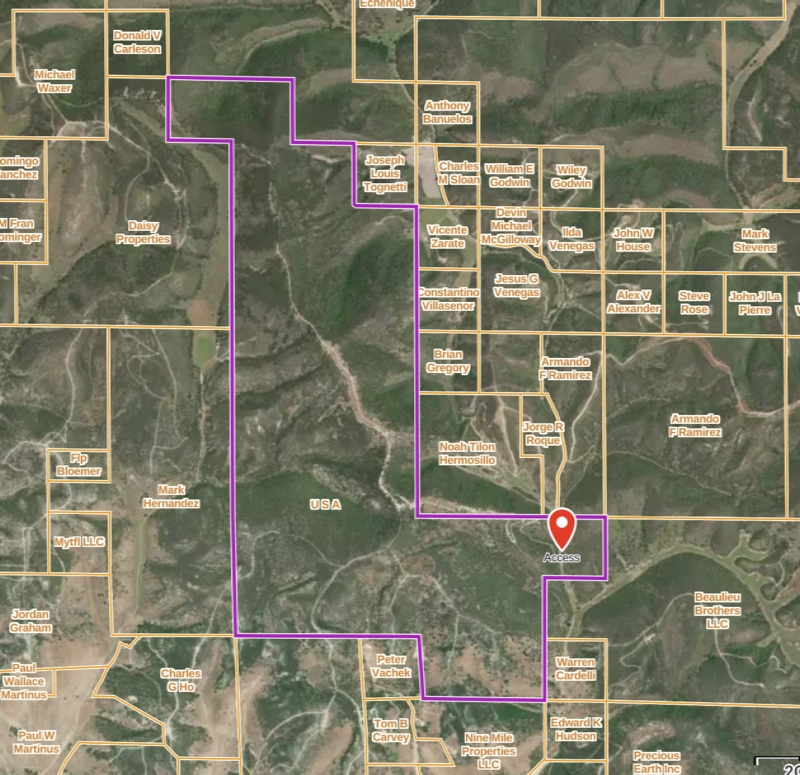
OnX Maps was founded in 2009 to help hunters see public land boundaries while hunting. Boundaries between public and private lands might have fences or might be posted, but sometimes do not. Knowing land boundaries ensures that hunters are not trespassing on private land, or allows them to identify the landowner to request access. In addition, I have read about landowners who attempt to tell hunters that certain lands are private, when in fact they are public. Lastly, some public lands are only available by using public easements to roads through private property.

Map showing huntable public land surrounded by private land, with access road going through private property.
LandAccess.jpg
LandAccess.jpg (458.1 KiB) Viewed 1378 times

onX's first product was a Hunt Chip (micro SD card) for most Garmin GPS handheld units. (Note: the chip is available for $120.)

onX Hunt was first available as an application in 2013, providing hunters with comprehensive digital maps.

onX Offroad followed in 2019 for offroad trails, onX Backcountry in 2021 for hiking, trail running, and skiing.

OnX Maps is headquartered in Missoula, Montana.

I'm familiar with and use onX Hunt and onX Offroad so will talk about those.


onX Hunt and Offroad (Common Features)

Where to get the App

The mobile apps are available from the Apple Store and Google Play. They are free but marginally useful without a subscription.


App cost

Once you have a subscription, the apps can be used on any platform (I believe any number). Data developed on one platform (e.g., a waypoint, route, or track) will automatically be synced to all other platforms.

Both apps are $30 per year for a "Premium" subscription and $100 per year for an "Elite" subscription.


App operating system

onX apps run on iOS, Android, and as a web-based app for desktops.

The web-based app is necessary for planning, and for importing (4MB limit) or exporting standard file formats (e.g., GPX, KML). In the field without online Internet access, you can only transfer data to other people who are also using the same app.


onx Offroad

Primary function of the App

onX Offroad is fine for navigating offroad trails. It has an extensive library of known offroad trails, which include clearly marked "routes", difficulty ratings, and elevation profiles (graph). "Routes" (in quotes) because they're just line. There is no direction information given, such as "turn right", "bear left".

Virtually all GPS navigation apps offer the same features as onX Offroad. I tend to like the satellite maps.

The Elite version gives you property boundaries and landowner names (like Hunt).

Examples of how you have used the App

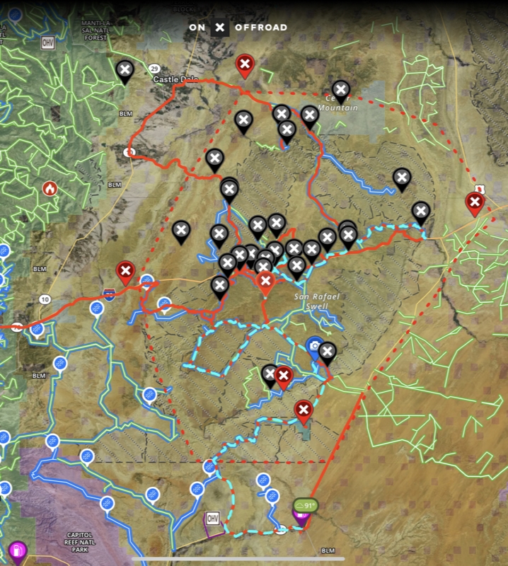
onX Offroad is my preferred Offroad app. It allows both following routes and recording actual tracks while doing so.

Sample screen shot of San Rafael Swell map with routes, tracks, and waypoints.
SanRafaelSwellOffroad.jpg
SanRafaelSwellOffroad.jpg (556.14 KiB) Viewed 1377 times
Pros of the App

The price for the Premium subscription is reasonable. The app provides all of the basic features that are useful.


onx Hunt

The Premium subscription gives you one state only. Elite provides all 50 states.

onX Hunt Elite, possibly recognizing that hunting is seasonal, is available for $15 per month.

Primary function of the App

The original purpose of onX Hunt was to keep hunters from trespassing into private land while hunting.


Examples of how you have used the App

I have not used onX Hunt while hunting. Based on what I've seen in online hunting groups, it is the preferred app of many hunters.


Pros of the App

The price for the Premium subscription is reasonable. The app provides all of the basic features that are useful. Creating waypoints, recording tracks.

Many map layers are provided:
  • Private Lands
  • Government Lands
  • Hunting Zones
  • Possible Access Points
  • State Game Refuges
  • Active and Historical Wildfires
  • Drought Data
  • Air Quality
  • Precipitation Radar
  • CWD (CHronic Wasting Disease) Positive Counties
  • CWD Zones and Locations
  • Wildreness Areas
  • US Fish and Wildlife Serice Hunt Areas
  • Slope Angle (of terrain)
  • Trails
  • Trail Slope
  • Trail Mileages
  • Roadless Areas
  • Motorized Roads and Trails
  • Recreation Sites
  • Forest Visitor Maps (somewhat low resolution)
  • Timber Cuts
  • Wetlands
  • Acorn Producing Oaks
  • Thermal Deer Cover
  • Deciduous vs. Coniferous
  • Elk Distribution
  • Mule Deer Distribution'
  • B&C Records for Elk, Mule Deer, and Pronghorn

onX Cons for both Offroad and Hunt

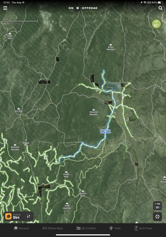
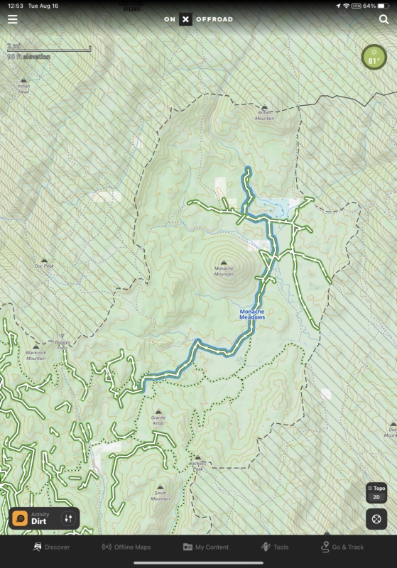
The onX apps provide only three kinds of 2D (looking straight down) maps: 1) fairly high-resolution satellite, 2) topographic, and 3) a hybrid that merges both. Most map features are available in a 3D viewing mode. Most other navigation apps provide a much wider variety of map types. Virtually all other apps include USGS topographic maps, which are somewhat of a gold standard. The information provided on onX topographic maps is limited. Following are sample maps:

Satellite Map for Offroad (Hunt is similar)
OffroadSatellite.jpg
OffroadSatellite.jpg (404.92 KiB) Viewed 1382 times
Topo Map for Offroad (Hunt is similar)
OffroadTopo.jpg
OffroadTopo.jpg (460.08 KiB) Viewed 1376 times
Hybrid Map for Offroad (Hunt is similar)
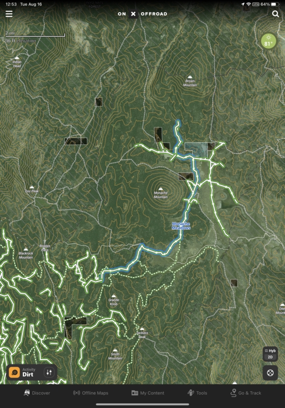
OffroadHybrid.jpg
OffroadHybrid.jpg (483.82 KiB) Viewed 1375 times

Downloading offline maps is a real pain. Unlike some apps which permit large areas to be selected and downloaded, onX apps allow downloading in 5-mile by 5-mile high-resolution squares, 10-mile by 10-mile medium-resolution squares, or 150-mile by 150-mile low-resolution squares. If you want to download a large area in high resolution, you must successively position each 5x5 square individually and download, making sure they overlap just enough. While you can position the next while downloading the previous, it's very tedious.

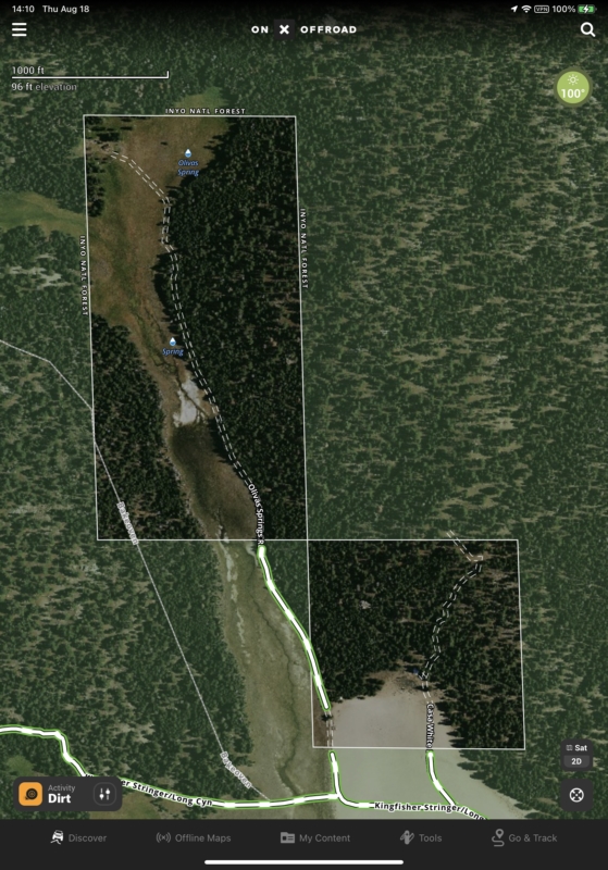
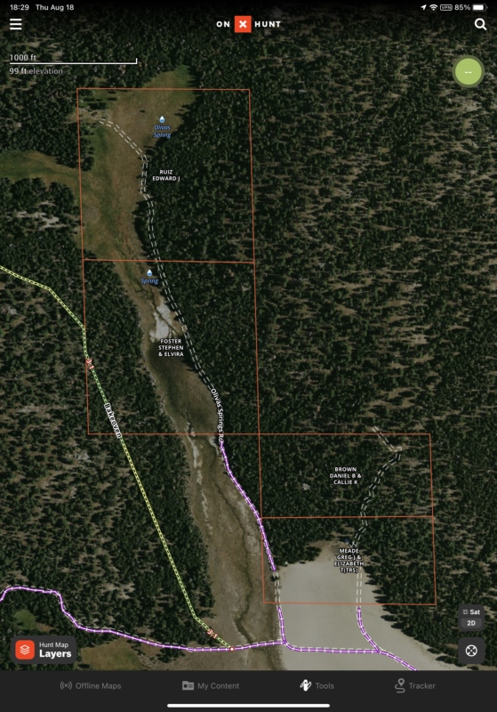
There are many similarities between the apps. Hunt has everything that Offroad offers except additional trail information. It would be nice to pay just a few bucks more (not $100 instead of $30) to get an Offroad version with property and landowner information, or a Hunt version with trail information.

A zoomed in Offroad map.
OffroadDetail.jpg
OffroadDetail.jpg (383.98 KiB) Viewed 1374 times
A zoomed in Hunt map.
HuntDetail.jpg
HuntDetail.jpg (402.14 KiB) Viewed 1374 times

The onX planning tools are terrible, and I don't like to have to use a slow desktop web app. I use Gaia GPS on an iPad for all of my planning since it already know virtually all trails. (Just noticed that Gaia GPS's Premium subscription is now $20 for the first year only instead of $40.)

The apps limit most interactions to portrait mode which can be a nuisance if your device is mounted in landscape orientation.

An odd happening perhaps, but I imported a GPX file of the path of the 2024 eclipse across the United States. While cleaning up memory use on my phone and iPad, I noted that the onX Offroad app was using many gigabytes. Working with their tech support, the resolution was finally to delete the eclipse track, then delete and reinstall Offroad. Other apps had no problem reclaiming memory after large amount of GPX data were deleted.

Honestly, for all of the additional features (though adding a few bugs), Gaia GPS seems a good value at $40 per year compared to onX $100 per year for an Elite subscription.

Diesel4x
Posts: 251
Joined: Thu Jul 20, 2017 6:49 pm
Call Sign: KF6KOC

Re: OAUSA Net - August 18, 2022 - Outdoor Applications

Post by Diesel4x » Thu Aug 18, 2022 5:51 pm

Good evening.
Please check in Randy KF6KOC and
Becky KF6RGR

thanks!

User avatar
AK6DH
Posts: 134
Joined: Thu Dec 12, 2019 8:39 pm
Call Sign: AK6DH
Location: Lancaster, CA

Re: OAUSA Net - August 18, 2022 - Outdoor Applications

Post by AK6DH » Thu Aug 18, 2022 6:20 pm

Please check in David - AK6DH.

Thanks.
73,
DavidH - AK6DH
2006 Jeep Rubicon

K9Nigel
Posts: 50
Joined: Wed Feb 03, 2021 8:40 pm
Call Sign: KC6JGZ

Re: OAUSA Net - August 18, 2022 - Outdoor Applications

Post by K9Nigel » Thu Aug 18, 2022 6:52 pm

Check in please - Russ KC6JGZ

User avatar
KA9WDX
Posts: 247
Joined: Thu Oct 20, 2016 7:40 pm
Call Sign: KA9WDX

Re: OAUSA Net - August 18, 2022 - Outdoor Applications

Post by KA9WDX » Thu Aug 18, 2022 6:53 pm

Check in please - Thanks - Bernie

User avatar
NotAMog
Global Moderator
Posts: 641
Joined: Fri Apr 18, 2008 6:40 pm
Call Sign: KD6GCO

Re: OAUSA Net - August 18, 2022 - Outdoor Applications

Post by NotAMog » Thu Aug 18, 2022 7:03 pm

Please check in -

John - KN6VL

Bruce - KD6GCO
Bruce Berger
KD6GCO
'72 Pinzgauer 710M 2.6i
'91 Honda ST1100 199,000miles and counting :shock: (I hope to make it to at least half the places this bike has been)
'04 Tacoma (soon to be for sale)
'07 Moto Guzzi Norge - Corsa Red - The faster color :mrgreen:
'21 UBCO 2x2 Electric Adventure Bike
'22 Energica Eva Ribelle Electric Motorcycle
'23 Jeep Gladiator Rubicon with Skinny Guy Camper

KM6OJB
Posts: 145
Joined: Mon Feb 19, 2018 8:54 pm
Call Sign: KM6OJB
Location: Rancho Cucamonga,CA

Re: OAUSA Net - August 18, 2022 - Outdoor Applications

Post by KM6OJB » Thu Aug 18, 2022 7:28 pm

This is KM6OJB please check me in.
Thanks
Joe

Post Reply

Return to “OAUSA AMATEUR RADIO NET PREVIEW”

Who is online

Users browsing this forum: No registered users and 2 guests